![](/images/other/stat-length.png)
![Trail On foot Rödental - Emil-Rädlein-Weg - Photo](https://media.geolcdn.com/t/1900/400/ext.pjpeg?maxdim=2&url=https%3A%2F%2Fmedia.geolcdn.com%2Ff%2F800c4313-e081-419c-86df-35ea7ac39f16.jpeg)
Emil-Rädlein-Weg
SityTrail - itinéraires balisés pédestres
Tous les sentiers balisés d’Europe PRO
![Length](/images/other/stat-length.png)
Length
40 km
![Max alt](https://static1.geolcdn.com/siteimages/upload/files/1508320355ic_sort_altitude_max_24dp.png)
Max alt
495 m
![Uphill gradient](https://static1.geolcdn.com/siteimages/upload/files/1508320355ic_sort_den_pos_24dp.png)
Uphill gradient
873 m
![Km-Effort](/images/other/stat-length.png)
Km-Effort
51 km
![Min alt](https://static1.geolcdn.com/siteimages/upload/files/1508320355ic_sort_altitude_min_24dp.png)
Min alt
313 m
![Downhill gradient](https://static1.geolcdn.com/siteimages/upload/files/1508320355ic_sort_den_neg_24dp.png)
Downhill gradient
752 m
![Boucle](https://static1.geolcdn.com/siteimages/upload/files/16400158638029165_repeat_loop_refresh_sync_direction_icon.png)
Boucle
No
Signpost
Creation date :
2022-02-11 16:34:55.709
Updated on :
2022-02-11 16:34:55.709
![On foot](https://static1.geolcdn.com/sitytour/trail-icons/100.png)
11h40
Difficulty : Very difficult
![Scan this QR Code to open this trail in the SityTrail application](https://capi.geolives.com/qq0zvz2zws4bq2lad0pu/sitytour/trails/3096540/qr.png?size=200)
FREE GPS app for hiking
About
Trail On foot of 40 km to be discovered at Bavaria, Landkreis Coburg, Rödental. This trail is proposed by SityTrail - itinéraires balisés pédestres.
Description
Trail created by Thüringerwald-Verein Coburg e. V..
mapped by roamingbecki 2015-01-11
Symbol: Blauer Punkt in weißem Rechteck
Positioning
Country:
Germany
Region :
Bavaria
Department/Province :
Landkreis Coburg
Municipality :
Rödental
Location:
Unknown
Start:(Dec)
Start:(UTM)
646546 ; 5574150 (32U) N.
Comments
Trails nearby
![Trail On foot - Coburger Rundwanderweg - Photo](https://media.geolcdn.com/t/375/260/ext.jpg?maxdim=2&url=https%3A%2F%2Fmedia.geolcdn.com%2Ff%2F4d36f45d-4bdf-4096-86be-bc3b2e36b2c5.jpeg)
![On foot On foot](https://static1.geolcdn.com/sitytour/trail-icons/100.png)
Coburger Rundwanderweg
On foot
Very difficult
,
Bavaria,
Coburg,
Germany
![](/images/other/stat-length.png)
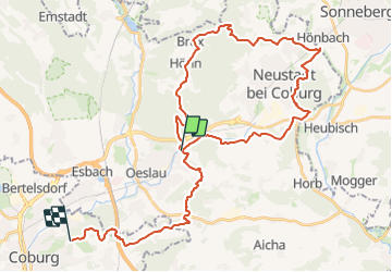
34 km | 43 km-effort
9h 53min
![](https://static1.geolcdn.com/siteimages/upload/files/16400158638029165_repeat_loop_refresh_sync_direction_icon.png)
Yes
![Trail On foot Rödental - Rundwanderweg Einberger Wald - Photo](https://media.geolcdn.com/t/375/260/ext.jpg?maxdim=2&url=https%3A%2F%2Fmedia.geolcdn.com%2Ff%2F7c3b7500-b5ff-4f92-8e19-e994d375a41f.jpeg)
![On foot On foot](https://static1.geolcdn.com/sitytour/trail-icons/100.png)
Rundwanderweg Einberger Wald
On foot
Easy
Rödental,
Bavaria,
Landkreis Coburg,
Germany
![](/images/other/stat-length.png)
3.2 km | 4.3 km-effort
58min
![](https://static1.geolcdn.com/siteimages/upload/files/16400158638029165_repeat_loop_refresh_sync_direction_icon.png)
No
![Trail On foot Rödental - Naturlehrpfad Lauterburg - Photo](https://media.geolcdn.com/t/375/260/ext.jpg?maxdim=2&url=https%3A%2F%2Fmedia.geolcdn.com%2Ff%2F2d646f59-49a1-48ed-a5b2-1181a314fec0.jpeg)
![On foot On foot](https://static1.geolcdn.com/sitytour/trail-icons/100.png)
Naturlehrpfad Lauterburg
On foot
Easy
Rödental,
Bavaria,
Landkreis Coburg,
Germany
![](/images/other/stat-length.png)
3.9 km | 4.9 km-effort
1h 7min
![](https://static1.geolcdn.com/siteimages/upload/files/16400158638029165_repeat_loop_refresh_sync_direction_icon.png)
No
![Trail Walking - w-duitsland-wandelroute-coburg - Photo](https://media.geolcdn.com/t/375/260/ext.jpg?maxdim=2&url=https%3A%2F%2Fstatic1.geolcdn.com%2Fsiteimages%2Fupload%2Ffiles%2F1553511878bg_sport_marche.png)
![Walking Walking](https://static1.geolcdn.com/sitytour/trail-icons/101.png)
w-duitsland-wandelroute-coburg
Walking
Very easy
,
Bavaria,
Coburg,
Germany
![](/images/other/stat-length.png)
17.1 km | 23 km-effort
Unknown
![](https://static1.geolcdn.com/siteimages/upload/files/16400158638029165_repeat_loop_refresh_sync_direction_icon.png)
Yes
![Trail Running Neustadt bei Coburg - jos allemagne - Photo](https://media.geolcdn.com/t/375/260/ext.jpg?maxdim=2&url=https%3A%2F%2Fstatic1.geolcdn.com%2Fsiteimages%2Fupload%2Ffiles%2F1524743154running.jpg)
![Running Running](https://static1.geolcdn.com/sitytour/trail-icons/103.png)
jos allemagne
Running
Very easy
Neustadt bei Coburg,
Bavaria,
Landkreis Coburg,
Germany
![](/images/other/stat-length.png)
10.2 km | 10.9 km-effort
1h 11min
![](https://static1.geolcdn.com/siteimages/upload/files/16400158638029165_repeat_loop_refresh_sync_direction_icon.png)
Yes