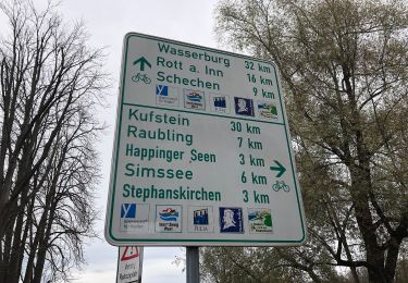
![](/images/other/stat-length.png)
![Trail On foot Unknown - SalzAlpenWeg Rosenheim-Chiemsee - Photo](https://media.geolcdn.com/t/1900/400/ext.pjpeg?maxdim=2&url=https%3A%2F%2Fstatic1.geolcdn.com%2Fsiteimages%2Fupload%2Ffiles%2F1545311037marcheuse_200dpi.jpg)
SalzAlpenWeg Rosenheim-Chiemsee
SityTrail - itinéraires balisés pédestres
Tous les sentiers balisés d’Europe GUIDE+
![Length](/images/other/stat-length.png)
![Max alt](https://static1.geolcdn.com/siteimages/upload/files/1508320355ic_sort_altitude_max_24dp.png)
![Uphill gradient](https://static1.geolcdn.com/siteimages/upload/files/1508320355ic_sort_den_pos_24dp.png)
![Km-Effort](/images/other/stat-length.png)
![Min alt](https://static1.geolcdn.com/siteimages/upload/files/1508320355ic_sort_altitude_min_24dp.png)
![Downhill gradient](https://static1.geolcdn.com/siteimages/upload/files/1508320355ic_sort_den_neg_24dp.png)
![Boucle](https://static1.geolcdn.com/siteimages/upload/files/16400158638029165_repeat_loop_refresh_sync_direction_icon.png)
![On foot](https://static1.geolcdn.com/sitytour/trail-icons/100.png)
8h06
Difficulty : Difficult
![Scan this QR Code to open this trail in the SityTrail application](https://capi.geolives.com/qq0zvz2zws4bq2lad0pu/sitytour/trails/3096400/qr.png?size=200)
FREE GPS app for hiking
About
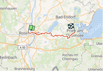
Trail On foot of 29 km to be discovered at Bavaria, Rosenheim. This trail is proposed by SityTrail - itinéraires balisés pédestres.
Description
Trail created by Gemeinde Stephanskirchen.
Symbol: Gelber Hintergrund mit den Silhouetten dreier Gipfel in roter Farbe. Symbole sind an Bäumen gesprüht oder als Aufkleber auf bestehenden Wegweisern. Zum Teil auch gelbe, große Blechschilder mit der Beschrifung "SalzAlpenWeg Rosenheim-Chiemsee"
Positioning
Comments
Trails nearby
![Trail On foot Stephanskirchen - Naturraum Hofau-Innleiten - Photo](https://media.geolcdn.com/t/375/260/f7e76397-2e76-467c-b91f-29c3b089d94a.jpeg&format=jpg&maxdim=2)
![On foot On foot](https://static1.geolcdn.com/sitytour/trail-icons/100.png)
On foot
![](/images/other/stat-length.png)
![](https://static1.geolcdn.com/siteimages/upload/files/16400158638029165_repeat_loop_refresh_sync_direction_icon.png)