![](/images/other/stat-length.png)
![Trail On foot Gau-Bischofsheim - Panoramaweg - Photo](https://media.geolcdn.com/t/1900/400/c4763d1a-06fc-4814-a287-397c95119d27.jpeg&format=pjpeg&maxdim=2)
Panoramaweg
SityTrail - itinéraires balisés pédestres
Tous les sentiers balisés d’Europe GUIDE+
![Length](/images/other/stat-length.png)
Length
3.4 km
![Max alt](https://static1.geolcdn.com/siteimages/upload/files/1508320355ic_sort_altitude_max_24dp.png)
Max alt
207 m
![Uphill gradient](https://static1.geolcdn.com/siteimages/upload/files/1508320355ic_sort_den_pos_24dp.png)
Uphill gradient
84 m
![Km-Effort](/images/other/stat-length.png)
Km-Effort
4.6 km
![Min alt](https://static1.geolcdn.com/siteimages/upload/files/1508320355ic_sort_altitude_min_24dp.png)
Min alt
123 m
![Downhill gradient](https://static1.geolcdn.com/siteimages/upload/files/1508320355ic_sort_den_neg_24dp.png)
Downhill gradient
89 m
![Boucle](https://static1.geolcdn.com/siteimages/upload/files/16400158638029165_repeat_loop_refresh_sync_direction_icon.png)
Boucle
Yes
Signpost
Creation date :
2022-02-11 16:28:50.833
Updated on :
2022-02-11 16:28:50.833
![On foot](https://static1.geolcdn.com/sitytour/trail-icons/100.png)
1h02
Difficulty : Easy
![Scan this QR Code to open this trail in the SityTrail application](https://capi.geolives.com/qq0zvz2zws4bq2lad0pu/sitytour/trails/3096378/qr.png?size=200)
FREE GPS app for hiking
About
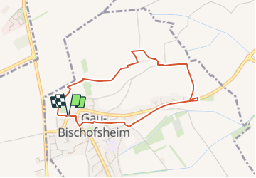
Trail On foot of 3.4 km to be discovered at Rhineland-Palatinate, Landkreis Mainz-Bingen, Gau-Bischofsheim. This trail is proposed by SityTrail - itinéraires balisés pédestres.
Description
Symbol: grüne Traube auf weißem Grund
Positioning
Country:
Germany
Region :
Rhineland-Palatinate
Department/Province :
Landkreis Mainz-Bingen
Municipality :
Gau-Bischofsheim
Location:
Unknown
Start:(Dec)
Start:(UTM)
447708 ; 5529414 (32U) N.
Comments
Trails nearby
![Trail On foot Zornheim - Hiwweltour Zornheimer Berg - Photo](https://media.geolcdn.com/t/375/260/df97a525-789e-43e2-8e9c-e190eea16e11.jpeg&format=jpg&maxdim=2)
![On foot On foot](https://static1.geolcdn.com/sitytour/trail-icons/100.png)
Hiwweltour Zornheimer Berg
On foot
Easy
Zornheim,
Rhineland-Palatinate,
Landkreis Mainz-Bingen,
Germany
![](/images/other/stat-length.png)
6.8 km | 9.2 km-effort
2h 5min
![](https://static1.geolcdn.com/siteimages/upload/files/16400158638029165_repeat_loop_refresh_sync_direction_icon.png)
Yes
![Trail On foot Zornheim - Nordic Walking Zornheim Nr. 3 - Photo](https://media.geolcdn.com/t/375/260/df97a525-789e-43e2-8e9c-e190eea16e11.jpeg&format=jpg&maxdim=2)
![On foot On foot](https://static1.geolcdn.com/sitytour/trail-icons/100.png)
Nordic Walking Zornheim Nr. 3
On foot
Easy
Zornheim,
Rhineland-Palatinate,
Landkreis Mainz-Bingen,
Germany
![](/images/other/stat-length.png)
6 km | 6.9 km-effort
1h 33min
![](https://static1.geolcdn.com/siteimages/upload/files/16400158638029165_repeat_loop_refresh_sync_direction_icon.png)
Yes
![Trail On foot Zornheim - Nordic Walking Zornheim Nr. 2 - Photo](https://media.geolcdn.com/t/375/260/ec2f7315-9175-4f2f-9b0f-017f43864c1e.jpeg&format=jpg&maxdim=2)
![On foot On foot](https://static1.geolcdn.com/sitytour/trail-icons/100.png)
Nordic Walking Zornheim Nr. 2
On foot
Easy
Zornheim,
Rhineland-Palatinate,
Landkreis Mainz-Bingen,
Germany
![](/images/other/stat-length.png)
5.8 km | 7.2 km-effort
1h 38min
![](https://static1.geolcdn.com/siteimages/upload/files/16400158638029165_repeat_loop_refresh_sync_direction_icon.png)
Yes
![Trail On foot Zornheim - Nordic Walking Zornheim Nr. 1 - Photo](https://media.geolcdn.com/t/375/260/df97a525-789e-43e2-8e9c-e190eea16e11.jpeg&format=jpg&maxdim=2)
![On foot On foot](https://static1.geolcdn.com/sitytour/trail-icons/100.png)
Nordic Walking Zornheim Nr. 1
On foot
Easy
Zornheim,
Rhineland-Palatinate,
Landkreis Mainz-Bingen,
Germany
![](/images/other/stat-length.png)
4.8 km | 5.6 km-effort
1h 15min
![](https://static1.geolcdn.com/siteimages/upload/files/16400158638029165_repeat_loop_refresh_sync_direction_icon.png)
Yes
![Trail On foot Gau-Bischofsheim - Schwarzfelderweg - Photo](https://media.geolcdn.com/t/375/260/2adab82a-826f-447f-9fe1-fe346655d5ee.jpeg&format=jpg&maxdim=2)
![On foot On foot](https://static1.geolcdn.com/sitytour/trail-icons/100.png)
Schwarzfelderweg
On foot
Easy
Gau-Bischofsheim,
Rhineland-Palatinate,
Landkreis Mainz-Bingen,
Germany
![](/images/other/stat-length.png)
3.4 km | 3.9 km-effort
53min
![](https://static1.geolcdn.com/siteimages/upload/files/16400158638029165_repeat_loop_refresh_sync_direction_icon.png)
Yes
![Trail On foot Lörzweiler - Lörzweiler Weinwanderweg - Photo](https://media.geolcdn.com/t/375/260/09e888cd-4afe-4af0-8ff2-c1e2d36b4e5f.jpeg&format=jpg&maxdim=2)
![On foot On foot](https://static1.geolcdn.com/sitytour/trail-icons/100.png)
Lörzweiler Weinwanderweg
On foot
Easy
Lörzweiler,
Rhineland-Palatinate,
Landkreis Mainz-Bingen,
Germany
![](/images/other/stat-length.png)
4.9 km | 5.7 km-effort
1h 17min
![](https://static1.geolcdn.com/siteimages/upload/files/16400158638029165_repeat_loop_refresh_sync_direction_icon.png)
Yes
![Trail On foot Klein-Winternheim - [Rotes Eichenblatt] Mainz (Hbf) - Marienborn - Zahlbach - Photo](https://media.geolcdn.com/t/375/260/29f95c8a-1e3d-4c7e-9ab0-7a1f3486a7e7.jpeg&format=jpg&maxdim=2)
![On foot On foot](https://static1.geolcdn.com/sitytour/trail-icons/100.png)
[Rotes Eichenblatt] Mainz (Hbf) - Marienborn - Zahlbach
On foot
Easy
Klein-Winternheim,
Rhineland-Palatinate,
Landkreis Mainz-Bingen,
Germany
![](/images/other/stat-length.png)
7.5 km | 8.2 km-effort
1h 51min
![](https://static1.geolcdn.com/siteimages/upload/files/16400158638029165_repeat_loop_refresh_sync_direction_icon.png)
No
![Trail On foot Klein-Winternheim - Panoramaweg Klein-Winternheim - Photo](https://media.geolcdn.com/t/375/260/5d7fd195-a0ca-487d-b842-16e84861521c.jpeg&format=jpg&maxdim=2)
![On foot On foot](https://static1.geolcdn.com/sitytour/trail-icons/100.png)
Panoramaweg Klein-Winternheim
On foot
Easy
Klein-Winternheim,
Rhineland-Palatinate,
Landkreis Mainz-Bingen,
Germany
![](/images/other/stat-length.png)
3.8 km | 4.7 km-effort
1h 3min
![](https://static1.geolcdn.com/siteimages/upload/files/16400158638029165_repeat_loop_refresh_sync_direction_icon.png)
Yes
![Trail On foot Nierstein - Drei-Türme-Weg - Photo](https://media.geolcdn.com/t/375/260/ef4d55ed-52ff-4584-aa32-9bd4e0e40d61.jpeg&format=jpg&maxdim=2)
![On foot On foot](https://static1.geolcdn.com/sitytour/trail-icons/100.png)
Drei-Türme-Weg
On foot
Easy
Nierstein,
Rhineland-Palatinate,
Landkreis Mainz-Bingen,
Germany
![](/images/other/stat-length.png)
3 km | 3.6 km-effort
49min
![](https://static1.geolcdn.com/siteimages/upload/files/16400158638029165_repeat_loop_refresh_sync_direction_icon.png)
No