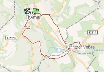
![](/images/other/stat-length.png)
![Trail On foot Themar - Themar-Rundwanderweg Grün - Photo](https://media.geolcdn.com/t/1900/400/fa57ddcc-ea52-47e2-a87f-cb5d71c9b16e.jpeg&format=pjpeg&maxdim=2)
Themar-Rundwanderweg Grün
SityTrail - itinéraires balisés pédestres
Tous les sentiers balisés d’Europe GUIDE+
![Length](/images/other/stat-length.png)
![Max alt](https://static1.geolcdn.com/siteimages/upload/files/1508320355ic_sort_altitude_max_24dp.png)
![Uphill gradient](https://static1.geolcdn.com/siteimages/upload/files/1508320355ic_sort_den_pos_24dp.png)
![Km-Effort](/images/other/stat-length.png)
![Min alt](https://static1.geolcdn.com/siteimages/upload/files/1508320355ic_sort_altitude_min_24dp.png)
![Downhill gradient](https://static1.geolcdn.com/siteimages/upload/files/1508320355ic_sort_den_neg_24dp.png)
![Boucle](https://static1.geolcdn.com/siteimages/upload/files/16400158638029165_repeat_loop_refresh_sync_direction_icon.png)
![On foot](https://static1.geolcdn.com/sitytour/trail-icons/100.png)
2h33
Difficulty : Easy
![Scan this QR Code to open this trail in the SityTrail application](https://capi.geolives.com/qq0zvz2zws4bq2lad0pu/sitytour/trails/3096098/qr.png?size=200)
FREE GPS app for hiking
About
Trail On foot of 8.3 km to be discovered at Thuringia, Landkreis Hildburghausen, Themar. This trail is proposed by SityTrail - itinéraires balisés pédestres.
Description
Infoportal der Verwaltungsgemeinschaft Feldstein mit den Mitgliedsgemeinden Ahlstädt, Bischofrod, Beinerstadt, Dingsleben, Ehrenberg, Eichenberg, Grimmelshausen, Grub, Henfstädt, Kloster Veßra, Lengfeld, Marisfeld, Oberstadt, Reurieth, Schmeheim und St. Bernhard.
Website: http://www.themar.de/public/tourismus/tourismus-freizeit-geocaching.aspx
Positioning
Comments
Trails nearby
![Trail On foot Kloster Veßra - Themar-Rundwanderweg Blau - Photo](https://media.geolcdn.com/t/375/260/224b2fe3-a292-4bca-a3c9-30e606dd8eee.jpeg&format=jpg&maxdim=2)
![On foot On foot](https://static1.geolcdn.com/sitytour/trail-icons/100.png)
On foot
![](/images/other/stat-length.png)
![](https://static1.geolcdn.com/siteimages/upload/files/16400158638029165_repeat_loop_refresh_sync_direction_icon.png)
![Trail On foot Themar - Themar-Rundwanderweg Rot - Photo](https://media.geolcdn.com/t/375/260/fa57ddcc-ea52-47e2-a87f-cb5d71c9b16e.jpeg&format=jpg&maxdim=2)
![On foot On foot](https://static1.geolcdn.com/sitytour/trail-icons/100.png)
On foot
![](/images/other/stat-length.png)
![](https://static1.geolcdn.com/siteimages/upload/files/16400158638029165_repeat_loop_refresh_sync_direction_icon.png)