![](/images/other/stat-length.png)
![Trail On foot Graineter Wald - Rundwanderweg 7 (Haidel) - Photo](https://media.geolcdn.com/t/1900/400/ext.pjpeg?maxdim=2&url=https%3A%2F%2Fstatic1.geolcdn.com%2Fsiteimages%2Fupload%2Ffiles%2F1545311037marcheuse_200dpi.jpg)
Rundwanderweg 7 (Haidel)
SityTrail - itinéraires balisés pédestres
Tous les sentiers balisés d’Europe GUIDE+
![Length](/images/other/stat-length.png)
Length
11 km
![Max alt](https://static1.geolcdn.com/siteimages/upload/files/1508320355ic_sort_altitude_max_24dp.png)
Max alt
1145 m
![Uphill gradient](https://static1.geolcdn.com/siteimages/upload/files/1508320355ic_sort_den_pos_24dp.png)
Uphill gradient
160 m
![Km-Effort](/images/other/stat-length.png)
Km-Effort
13.6 km
![Min alt](https://static1.geolcdn.com/siteimages/upload/files/1508320355ic_sort_altitude_min_24dp.png)
Min alt
884 m
![Downhill gradient](https://static1.geolcdn.com/siteimages/upload/files/1508320355ic_sort_den_neg_24dp.png)
Downhill gradient
294 m
![Boucle](https://static1.geolcdn.com/siteimages/upload/files/16400158638029165_repeat_loop_refresh_sync_direction_icon.png)
Boucle
No
Signpost
Creation date :
2022-02-11 16:00:42.573
Updated on :
2022-02-11 16:00:42.573
![On foot](https://static1.geolcdn.com/sitytour/trail-icons/100.png)
3h05
Difficulty : Easy
![Scan this QR Code to open this trail in the SityTrail application](https://capi.geolives.com/qq0zvz2zws4bq2lad0pu/sitytour/trails/3095606/qr.png?size=200)
FREE GPS app for hiking
About
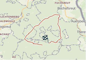
Trail On foot of 11 km to be discovered at Bavaria, Landkreis Freyung-Grafenau, Graineter Wald. This trail is proposed by SityTrail - itinéraires balisés pédestres.
Description
Trail created by Naturpark Bayerischer Wald.
Symbol: auf weißem, meist quadratischen Hintergrund ein roter runder Kreis mit weißer Wegnummer darin
Positioning
Country:
Germany
Region :
Bavaria
Department/Province :
Landkreis Freyung-Grafenau
Municipality :
Graineter Wald
Location:
Unknown
Start:(Dec)
Start:(UTM)
404587 ; 5408336 (33U) N.
Comments
Trails nearby
![Trail On foot Haidmühle - Hirschbergsteig - Photo](https://media.geolcdn.com/t/375/260/102bb971-ee74-4a16-bff4-417b2b03538a.jpeg&format=jpg&maxdim=2)
![On foot On foot](https://static1.geolcdn.com/sitytour/trail-icons/100.png)
Hirschbergsteig
On foot
Easy
Haidmühle,
Bavaria,
Landkreis Freyung-Grafenau,
Germany
![](/images/other/stat-length.png)
6 km | 7.3 km-effort
1h 39min
![](https://static1.geolcdn.com/siteimages/upload/files/16400158638029165_repeat_loop_refresh_sync_direction_icon.png)
No
![Trail On foot Graineter Wald - Rundwanderweg 5 (Haidel) - Photo](https://media.geolcdn.com/t/375/260/14324137-41ff-48e4-9ad8-f986586793ea.jpeg&format=jpg&maxdim=2)
![On foot On foot](https://static1.geolcdn.com/sitytour/trail-icons/100.png)
Rundwanderweg 5 (Haidel)
On foot
Easy
Graineter Wald,
Bavaria,
Landkreis Freyung-Grafenau,
Germany
![](/images/other/stat-length.png)
4.3 km | 6 km-effort
1h 21min
![](https://static1.geolcdn.com/siteimages/upload/files/16400158638029165_repeat_loop_refresh_sync_direction_icon.png)
No
![Trail On foot Grainet - Graineter Kapellenweg - Photo](https://media.geolcdn.com/t/375/260/df54c850-d0c3-4e64-8a25-eb9d963c6099.jpeg&format=jpg&maxdim=2)
![On foot On foot](https://static1.geolcdn.com/sitytour/trail-icons/100.png)
Graineter Kapellenweg
On foot
Easy
Grainet,
Bavaria,
Landkreis Freyung-Grafenau,
Germany
![](/images/other/stat-length.png)
8 km | 10.1 km-effort
2h 18min
![](https://static1.geolcdn.com/siteimages/upload/files/16400158638029165_repeat_loop_refresh_sync_direction_icon.png)
No
![Trail On foot Haidmühle - Rundwanderweg 3 Weberbachklause - Photo](https://media.geolcdn.com/t/375/260/ext.jpg?maxdim=2&url=https%3A%2F%2Fstatic1.geolcdn.com%2Fsiteimages%2Fupload%2Ffiles%2F1545311037marcheuse_200dpi.jpg)
![On foot On foot](https://static1.geolcdn.com/sitytour/trail-icons/100.png)
Rundwanderweg 3 Weberbachklause
On foot
Easy
Haidmühle,
Bavaria,
Landkreis Freyung-Grafenau,
Germany
![](/images/other/stat-length.png)
7.2 km | 9.7 km-effort
2h 12min
![](https://static1.geolcdn.com/siteimages/upload/files/16400158638029165_repeat_loop_refresh_sync_direction_icon.png)
Yes
![Trail On foot Graineter Wald - Rundwanderweg 6 (Haidel) - Photo](https://media.geolcdn.com/t/375/260/ext.jpg?maxdim=2&url=https%3A%2F%2Fstatic1.geolcdn.com%2Fsiteimages%2Fupload%2Ffiles%2F1545311037marcheuse_200dpi.jpg)
![On foot On foot](https://static1.geolcdn.com/sitytour/trail-icons/100.png)
Rundwanderweg 6 (Haidel)
On foot
Easy
Graineter Wald,
Bavaria,
Landkreis Freyung-Grafenau,
Germany
![](/images/other/stat-length.png)
7.4 km | 8.9 km-effort
2h 1min
![](https://static1.geolcdn.com/siteimages/upload/files/16400158638029165_repeat_loop_refresh_sync_direction_icon.png)
No