![](/images/other/stat-length.png)
![Trail On foot Wülknitz - Gebietswanderweg Roter Strich - Photo](https://media.geolcdn.com/t/1900/400/ext.pjpeg?maxdim=2&url=https%3A%2F%2Fmedia.geolcdn.com%2Ff%2Fb4d2ee8c-6927-454e-8fc4-72ba52d78b49.jpeg)
Gebietswanderweg Roter Strich
SityTrail - itinéraires balisés pédestres
Tous les sentiers balisés d’Europe PRO
![Length](/images/other/stat-length.png)
Length
7.9 km
![Max alt](https://static1.geolcdn.com/siteimages/upload/files/1508320355ic_sort_altitude_max_24dp.png)
Max alt
118 m
![Uphill gradient](https://static1.geolcdn.com/siteimages/upload/files/1508320355ic_sort_den_pos_24dp.png)
Uphill gradient
54 m
![Km-Effort](/images/other/stat-length.png)
Km-Effort
8.6 km
![Min alt](https://static1.geolcdn.com/siteimages/upload/files/1508320355ic_sort_altitude_min_24dp.png)
Min alt
94 m
![Downhill gradient](https://static1.geolcdn.com/siteimages/upload/files/1508320355ic_sort_den_neg_24dp.png)
Downhill gradient
52 m
![Boucle](https://static1.geolcdn.com/siteimages/upload/files/16400158638029165_repeat_loop_refresh_sync_direction_icon.png)
Boucle
No
Signpost
Creation date :
2022-02-11 15:52:50.371
Updated on :
2022-02-11 15:52:50.371
![On foot](https://static1.geolcdn.com/sitytour/trail-icons/100.png)
1h57
Difficulty : Easy
![Scan this QR Code to open this trail in the SityTrail application](https://capi.geolives.com/qq0zvz2zws4bq2lad0pu/sitytour/trails/3095403/qr.png?size=200)
FREE GPS app for hiking
About
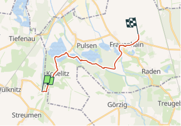
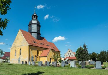
Trail On foot of 7.9 km to be discovered at Saxony, Meißen, Wülknitz. This trail is proposed by SityTrail - itinéraires balisés pédestres.
Description
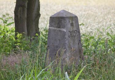
Markierung südlich Löbsal ist nicht eindeutig
Symbol: red bar on withe ground
Positioning
Country:
Germany
Region :
Saxony
Department/Province :
Meißen
Municipality :
Wülknitz
Location:
Unknown
Start:(Dec)
Start:(UTM)
389745 ; 5691960 (33U) N.
Comments
Trails nearby
![Trail On foot Niederau - Lehrpfad](https://media.geolcdn.com/t/375/260/ext.jpg?maxdim=2&url=https%3A%2F%2Fmedia.geolcdn.com%2Ff%2Fac191bcd-b5a2-411d-bb70-459e308b7f9f.jpeg)
![On foot On foot](https://static1.geolcdn.com/sitytour/trail-icons/100.png)
Lehrpfad "Obere Aue"
On foot
Easy
Niederau,
Saxony,
Meißen,
Germany
![](/images/other/stat-length.png)
9.6 km | 11.2 km-effort
2h 32min
![](https://static1.geolcdn.com/siteimages/upload/files/16400158638029165_repeat_loop_refresh_sync_direction_icon.png)
Yes
![Trail On foot Hirschfeld - Grenzsteinweg - Photo](https://media.geolcdn.com/t/375/260/ext.jpg?maxdim=2&url=https%3A%2F%2Fmedia.geolcdn.com%2Ff%2Fc3dc7a6a-4d10-482f-850c-9ab826bbf46c.jpeg)
![On foot On foot](https://static1.geolcdn.com/sitytour/trail-icons/100.png)
Grenzsteinweg
On foot
Easy
Hirschfeld,
Brandenburg,
Elbe-Elster,
Germany
![](/images/other/stat-length.png)
10.4 km | 12.2 km-effort
2h 46min
![](https://static1.geolcdn.com/siteimages/upload/files/16400158638029165_repeat_loop_refresh_sync_direction_icon.png)
No
![Trail On foot Lommatzsch - Ketzerbachweg - Photo](https://media.geolcdn.com/t/375/260/ext.jpg?maxdim=2&url=https%3A%2F%2Fmedia.geolcdn.com%2Ff%2Fbb44fbaf-4ee7-4c5d-9428-24d96380d883.jpeg)
![On foot On foot](https://static1.geolcdn.com/sitytour/trail-icons/100.png)
![Trail On foot Großenhain - Großenhain - Nasseböhla - Zabeltitz - Photo](https://media.geolcdn.com/t/375/260/ext.jpg?maxdim=2&url=https%3A%2F%2Fmedia.geolcdn.com%2Ff%2Fa8747d80-595c-4965-be39-0f4d74cb6708.jpeg)
![On foot On foot](https://static1.geolcdn.com/sitytour/trail-icons/100.png)
Großenhain - Nasseböhla - Zabeltitz
On foot
Easy
Großenhain,
Saxony,
Meißen,
Germany
![](/images/other/stat-length.png)
6.8 km | 7.3 km-effort
1h 39min
![](https://static1.geolcdn.com/siteimages/upload/files/16400158638029165_repeat_loop_refresh_sync_direction_icon.png)
No
![Trail On foot Großenhain - Großenhain - Baudaer Mühle - Zabeltitz - Photo](https://media.geolcdn.com/t/375/260/ext.jpg?maxdim=2&url=https%3A%2F%2Fmedia.geolcdn.com%2Ff%2Fc4575907-d2c3-46d0-babb-908d9281b3a8.jpeg)
![On foot On foot](https://static1.geolcdn.com/sitytour/trail-icons/100.png)
Großenhain - Baudaer Mühle - Zabeltitz
On foot
Easy
Großenhain,
Saxony,
Meißen,
Germany
![](/images/other/stat-length.png)
3.2 km | 3.4 km-effort
45min
![](https://static1.geolcdn.com/siteimages/upload/files/16400158638029165_repeat_loop_refresh_sync_direction_icon.png)
No
![Trail On foot Nünchritz - Ww Floßkanalroute - Photo](https://media.geolcdn.com/t/375/260/ext.jpg?maxdim=2&url=https%3A%2F%2Fmedia.geolcdn.com%2Ff%2F5bc07644-b500-4efb-b83f-acecf4d504b8.jpeg)
![On foot On foot](https://static1.geolcdn.com/sitytour/trail-icons/100.png)
Ww Floßkanalroute
On foot
Medium
Nünchritz,
Saxony,
Meißen,
Germany
![](/images/other/stat-length.png)
19.7 km | 21 km-effort
4h 46min
![](https://static1.geolcdn.com/siteimages/upload/files/16400158638029165_repeat_loop_refresh_sync_direction_icon.png)
No
![Trail On foot Diera-Zehren - Lommatzscher Weg - Photo](https://media.geolcdn.com/t/375/260/ext.jpg?maxdim=2&url=https%3A%2F%2Fstatic1.geolcdn.com%2Fsiteimages%2Fupload%2Ffiles%2F1545311037marcheuse_200dpi.jpg)
![On foot On foot](https://static1.geolcdn.com/sitytour/trail-icons/100.png)
![Trail On foot Diera-Zehren - Hebelei-Rundweg - Photo](https://media.geolcdn.com/t/375/260/ext.jpg?maxdim=2&url=https%3A%2F%2Fstatic1.geolcdn.com%2Fsiteimages%2Fupload%2Ffiles%2F1545311037marcheuse_200dpi.jpg)
![On foot On foot](https://static1.geolcdn.com/sitytour/trail-icons/100.png)
![Trail On foot Niederau - Rundweg Gelber Punkt - Photo](https://media.geolcdn.com/t/375/260/ext.jpg?maxdim=2&url=https%3A%2F%2Fstatic1.geolcdn.com%2Fsiteimages%2Fupload%2Ffiles%2F1545311037marcheuse_200dpi.jpg)
![On foot On foot](https://static1.geolcdn.com/sitytour/trail-icons/100.png)
Rundweg Gelber Punkt
On foot
Easy
Niederau,
Saxony,
Meißen,
Germany
![](/images/other/stat-length.png)
7.5 km | 8.6 km-effort
1h 57min
![](https://static1.geolcdn.com/siteimages/upload/files/16400158638029165_repeat_loop_refresh_sync_direction_icon.png)
Yes