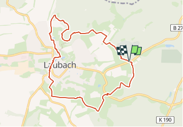
![](/images/other/stat-length.png)
![Trail On foot Laubach - Laubach Panoramaweg - Photo](https://media.geolcdn.com/t/1900/400/e34012cc-d8aa-4f6c-9a87-671f68d3e4a4.jpeg&format=pjpeg&maxdim=2)
Laubach Panoramaweg
SityTrail - itinéraires balisés pédestres
Tous les sentiers balisés d’Europe GUIDE+
![Length](/images/other/stat-length.png)
![Max alt](https://static1.geolcdn.com/siteimages/upload/files/1508320355ic_sort_altitude_max_24dp.png)
![Uphill gradient](https://static1.geolcdn.com/siteimages/upload/files/1508320355ic_sort_den_pos_24dp.png)
![Km-Effort](/images/other/stat-length.png)
![Min alt](https://static1.geolcdn.com/siteimages/upload/files/1508320355ic_sort_altitude_min_24dp.png)
![Downhill gradient](https://static1.geolcdn.com/siteimages/upload/files/1508320355ic_sort_den_neg_24dp.png)
![Boucle](https://static1.geolcdn.com/siteimages/upload/files/16400158638029165_repeat_loop_refresh_sync_direction_icon.png)
![On foot](https://static1.geolcdn.com/sitytour/trail-icons/100.png)
2h34
Difficulty : Easy
![Scan this QR Code to open this trail in the SityTrail application](https://capi.geolives.com/qq0zvz2zws4bq2lad0pu/sitytour/trails/3095202/qr.png?size=200)
FREE GPS app for hiking
About
Trail On foot of 8.9 km to be discovered at Hesse, Landkreis Gießen, Laubach. This trail is proposed by SityTrail - itinéraires balisés pédestres.
Description
Trail created by Laubach & VHC.
complete ; neu angelegt 2014-02 VHC Laubach
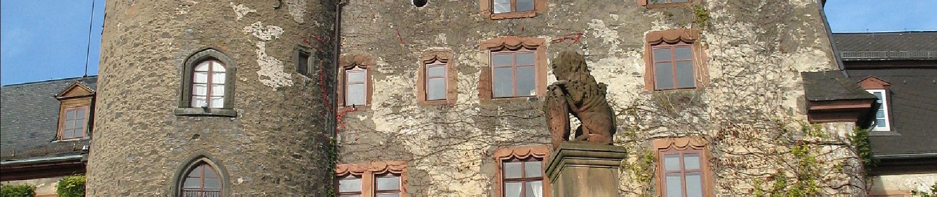
Symbol: Gelber Hintergrund mit weißem Rahmen und mittiges schwarzen P, drunter Laubach in schwarz mit halber Schloßspitze (ALT:roter Milan auf weißem grund)
Positioning
Comments
Trails nearby
![Trail On foot Schotten - Rundwanderweg Einartshausen E1 - Photo](https://media.geolcdn.com/t/375/260/1a30cdf5-be1f-4e2e-a426-3cc85314c985.jpeg&format=jpg&maxdim=2)
![On foot On foot](https://static1.geolcdn.com/sitytour/trail-icons/100.png)
On foot
![](/images/other/stat-length.png)
![](https://static1.geolcdn.com/siteimages/upload/files/16400158638029165_repeat_loop_refresh_sync_direction_icon.png)
![Trail On foot Laubach - Wetterweg - Photo](https://media.geolcdn.com/t/375/260/2100a7e7-50ec-49f5-a2a2-5fae1b4dcbe5.jpeg&format=jpg&maxdim=2)
![On foot On foot](https://static1.geolcdn.com/sitytour/trail-icons/100.png)
On foot
![](/images/other/stat-length.png)
![](https://static1.geolcdn.com/siteimages/upload/files/16400158638029165_repeat_loop_refresh_sync_direction_icon.png)
![Trail On foot Grünberg - Pfannenweg - Photo](https://media.geolcdn.com/t/375/260/aefb5773-fc8e-45bb-b4bf-010d0e2109b8.jpeg&format=jpg&maxdim=2)
![On foot On foot](https://static1.geolcdn.com/sitytour/trail-icons/100.png)
On foot
![](/images/other/stat-length.png)
![](https://static1.geolcdn.com/siteimages/upload/files/16400158638029165_repeat_loop_refresh_sync_direction_icon.png)
![Trail On foot Grünberg - Grünberg - Nordic 4 Stadtwald-Route - Photo](https://media.geolcdn.com/t/375/260/aefb5773-fc8e-45bb-b4bf-010d0e2109b8.jpeg&format=jpg&maxdim=2)
![On foot On foot](https://static1.geolcdn.com/sitytour/trail-icons/100.png)
On foot
![](/images/other/stat-length.png)
![](https://static1.geolcdn.com/siteimages/upload/files/16400158638029165_repeat_loop_refresh_sync_direction_icon.png)
![Trail On foot Grünberg - Grünberg - Nordic 3 Teichkopf-Route - Photo](https://media.geolcdn.com/t/375/260/aefb5773-fc8e-45bb-b4bf-010d0e2109b8.jpeg&format=jpg&maxdim=2)
![On foot On foot](https://static1.geolcdn.com/sitytour/trail-icons/100.png)
On foot
![](/images/other/stat-length.png)
![](https://static1.geolcdn.com/siteimages/upload/files/16400158638029165_repeat_loop_refresh_sync_direction_icon.png)
![Trail On foot Grünberg - Grünberg - Nordic 2 Raubschloß-Route - Photo](https://media.geolcdn.com/t/375/260/aefb5773-fc8e-45bb-b4bf-010d0e2109b8.jpeg&format=jpg&maxdim=2)
![On foot On foot](https://static1.geolcdn.com/sitytour/trail-icons/100.png)
On foot
![](/images/other/stat-length.png)
![](https://static1.geolcdn.com/siteimages/upload/files/16400158638029165_repeat_loop_refresh_sync_direction_icon.png)
![Trail On foot Laubach - Rundweg Laubach - Photo](https://media.geolcdn.com/t/375/260/bffec006-1ed4-4d5e-92eb-b1080eb29654.jpeg&format=jpg&maxdim=2)
![On foot On foot](https://static1.geolcdn.com/sitytour/trail-icons/100.png)
On foot
![](/images/other/stat-length.png)
![](https://static1.geolcdn.com/siteimages/upload/files/16400158638029165_repeat_loop_refresh_sync_direction_icon.png)
![Trail On foot Laubach - Laubach Steinbachweg - Photo](https://media.geolcdn.com/t/375/260/ext.jpg?maxdim=2&url=https%3A%2F%2Fstatic1.geolcdn.com%2Fsiteimages%2Fupload%2Ffiles%2F1545311037marcheuse_200dpi.jpg)
![On foot On foot](https://static1.geolcdn.com/sitytour/trail-icons/100.png)
On foot
![](/images/other/stat-length.png)
![](https://static1.geolcdn.com/siteimages/upload/files/16400158638029165_repeat_loop_refresh_sync_direction_icon.png)
![Trail On foot Laubach - Laubach Ramsbergrundweg - Photo](https://media.geolcdn.com/t/375/260/ext.jpg?maxdim=2&url=https%3A%2F%2Fstatic1.geolcdn.com%2Fsiteimages%2Fupload%2Ffiles%2F1545311037marcheuse_200dpi.jpg)
![On foot On foot](https://static1.geolcdn.com/sitytour/trail-icons/100.png)
On foot
![](/images/other/stat-length.png)
![](https://static1.geolcdn.com/siteimages/upload/files/16400158638029165_repeat_loop_refresh_sync_direction_icon.png)