![](/images/other/stat-length.png)
![Trail On foot Paderborn - Dahler Aussichtstour - Photo](https://media.geolcdn.com/t/1900/400/ext.pjpeg?maxdim=2&url=https%3A%2F%2Fmedia.geolcdn.com%2Ff%2F803a2156-810f-49e6-a52f-f1b8d804bcd3.jpeg)
Dahler Aussichtstour
SityTrail - itinéraires balisés pédestres
Tous les sentiers balisés d’Europe PRO
![Length](/images/other/stat-length.png)
Length
12.9 km
![Max alt](https://static1.geolcdn.com/siteimages/upload/files/1508320355ic_sort_altitude_max_24dp.png)
Max alt
329 m
![Uphill gradient](https://static1.geolcdn.com/siteimages/upload/files/1508320355ic_sort_den_pos_24dp.png)
Uphill gradient
212 m
![Km-Effort](/images/other/stat-length.png)
Km-Effort
15.8 km
![Min alt](https://static1.geolcdn.com/siteimages/upload/files/1508320355ic_sort_altitude_min_24dp.png)
Min alt
220 m
![Downhill gradient](https://static1.geolcdn.com/siteimages/upload/files/1508320355ic_sort_den_neg_24dp.png)
Downhill gradient
225 m
![Boucle](https://static1.geolcdn.com/siteimages/upload/files/16400158638029165_repeat_loop_refresh_sync_direction_icon.png)
Boucle
No
Signpost
Creation date :
2022-02-11 15:44:59.941
Updated on :
2022-02-11 15:44:59.941
![On foot](https://static1.geolcdn.com/sitytour/trail-icons/100.png)
3h35
Difficulty : Easy
![Scan this QR Code to open this trail in the SityTrail application](https://capi.geolives.com/qq0zvz2zws4bq2lad0pu/sitytour/trails/3095186/qr.png?size=200)
FREE GPS app for hiking
About
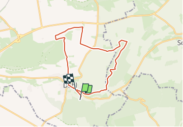
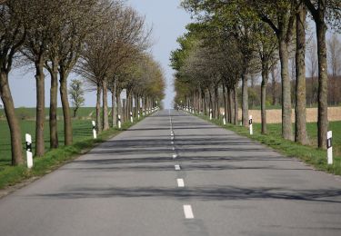
Trail On foot of 12.9 km to be discovered at North Rhine-Westphalia, Kreis Paderborn, Paderborn. This trail is proposed by SityTrail - itinéraires balisés pédestres.
Description
Sonnige Runde vom Ellerbachtal auf die Paderborner Hochfläche
Website: http://www.paderborner-karstrundweg.de
Positioning
Country:
Germany
Region :
North Rhine-Westphalia
Department/Province :
Kreis Paderborn
Municipality :
Paderborn
Location:
Unknown
Start:(Dec)
Start:(UTM)
490243 ; 5726528 (32U) N.
Comments
Trails nearby
![Trail On foot Paderborn - Dahl Rundweg A1 - Photo](https://media.geolcdn.com/t/375/260/ext.jpg?maxdim=2&url=https%3A%2F%2Fmedia.geolcdn.com%2Ff%2F37f14937-af38-4247-a5c2-932d8cd6427a.jpeg)
![On foot On foot](https://static1.geolcdn.com/sitytour/trail-icons/100.png)
Dahl Rundweg A1
On foot
Easy
Paderborn,
North Rhine-Westphalia,
Kreis Paderborn,
Germany
![](/images/other/stat-length.png)
3.6 km | 4.5 km-effort
1h 1min
![](https://static1.geolcdn.com/siteimages/upload/files/16400158638029165_repeat_loop_refresh_sync_direction_icon.png)
Yes
![Trail On foot Altenbeken - Schwaneyer Panoramaweg - Photo](https://media.geolcdn.com/t/375/260/ext.jpg?maxdim=2&url=https%3A%2F%2Fmedia.geolcdn.com%2Ff%2F6677e685-b94e-4aaf-ac5f-a6be76346ebc.jpeg)
![On foot On foot](https://static1.geolcdn.com/sitytour/trail-icons/100.png)
Schwaneyer Panoramaweg
On foot
Easy
Altenbeken,
North Rhine-Westphalia,
Kreis Paderborn,
Germany
![](/images/other/stat-length.png)
12.2 km | 16 km-effort
3h 38min
![](https://static1.geolcdn.com/siteimages/upload/files/16400158638029165_repeat_loop_refresh_sync_direction_icon.png)
No
![Trail On foot Paderborn - Paderborner Karstrundweg - Photo](https://media.geolcdn.com/t/375/260/ext.jpg?maxdim=2&url=https%3A%2F%2Fmedia.geolcdn.com%2Ff%2F04b17e81-542a-4fe8-ba5c-31ce6461a159.jpeg)
![On foot On foot](https://static1.geolcdn.com/sitytour/trail-icons/100.png)
Paderborner Karstrundweg
On foot
Easy
Paderborn,
North Rhine-Westphalia,
Kreis Paderborn,
Germany
![](/images/other/stat-length.png)
13.3 km | 17 km-effort
3h 51min
![](https://static1.geolcdn.com/siteimages/upload/files/16400158638029165_repeat_loop_refresh_sync_direction_icon.png)
No
![Trail On foot Altenbeken - Rundwanderweg A2 [Dune] - Photo](https://media.geolcdn.com/t/375/260/ext.jpg?maxdim=2&url=https%3A%2F%2Fmedia.geolcdn.com%2Ff%2Ff67a66a4-5038-45ed-847b-184bff3ced0b.jpeg)
![On foot On foot](https://static1.geolcdn.com/sitytour/trail-icons/100.png)
Rundwanderweg A2 [Dune]
On foot
Easy
Altenbeken,
North Rhine-Westphalia,
Kreis Paderborn,
Germany
![](/images/other/stat-length.png)
5.1 km | 6.6 km-effort
1h 29min
![](https://static1.geolcdn.com/siteimages/upload/files/16400158638029165_repeat_loop_refresh_sync_direction_icon.png)
Yes
![Trail On foot Borchen - Haxtergrund Rundweg Gelb - Photo](https://media.geolcdn.com/t/375/260/ext.jpg?maxdim=2&url=https%3A%2F%2Fmedia.geolcdn.com%2Ff%2Fc6b355c0-39d6-4653-84cd-f09aa3d6e194.jpeg)
![On foot On foot](https://static1.geolcdn.com/sitytour/trail-icons/100.png)
Haxtergrund Rundweg Gelb
On foot
Easy
Borchen,
North Rhine-Westphalia,
Kreis Paderborn,
Germany
![](/images/other/stat-length.png)
5.1 km | 6.7 km-effort
1h 31min
![](https://static1.geolcdn.com/siteimages/upload/files/16400158638029165_repeat_loop_refresh_sync_direction_icon.png)
Yes
![Trail On foot Paderborn - Haxtergrund Rundweg Violett - Photo](https://media.geolcdn.com/t/375/260/ext.jpg?maxdim=2&url=https%3A%2F%2Fmedia.geolcdn.com%2Ff%2Fc6b355c0-39d6-4653-84cd-f09aa3d6e194.jpeg)
![On foot On foot](https://static1.geolcdn.com/sitytour/trail-icons/100.png)
Haxtergrund Rundweg Violett
On foot
Easy
Paderborn,
North Rhine-Westphalia,
Kreis Paderborn,
Germany
![](/images/other/stat-length.png)
3.9 km | 5.1 km-effort
1h 10min
![](https://static1.geolcdn.com/siteimages/upload/files/16400158638029165_repeat_loop_refresh_sync_direction_icon.png)
Yes
![Trail On foot Paderborn - Mittelholz - Photo](https://media.geolcdn.com/t/375/260/ext.jpg?maxdim=2&url=https%3A%2F%2Fmedia.geolcdn.com%2Ff%2F6f45a554-454d-4ef5-9436-3fff121cf73c.jpeg)
![On foot On foot](https://static1.geolcdn.com/sitytour/trail-icons/100.png)
Mittelholz
On foot
Easy
Paderborn,
North Rhine-Westphalia,
Kreis Paderborn,
Germany
![](/images/other/stat-length.png)
3.3 km | 4.3 km-effort
58min
![](https://static1.geolcdn.com/siteimages/upload/files/16400158638029165_repeat_loop_refresh_sync_direction_icon.png)
No
![Trail On foot Borchen - Borchen Rundweg A3 - Photo](https://media.geolcdn.com/t/375/260/ext.jpg?maxdim=2&url=https%3A%2F%2Fmedia.geolcdn.com%2Ff%2Fbacd3811-5527-40be-8a3e-67b9e57ff3a3.jpeg)
![On foot On foot](https://static1.geolcdn.com/sitytour/trail-icons/100.png)
Borchen Rundweg A3
On foot
Easy
Borchen,
North Rhine-Westphalia,
Kreis Paderborn,
Germany
![](/images/other/stat-length.png)
4.5 km | 5.2 km-effort
1h 10min
![](https://static1.geolcdn.com/siteimages/upload/files/16400158638029165_repeat_loop_refresh_sync_direction_icon.png)
Yes
![Trail On foot Paderborn - Dahl Rundweg A2 - Photo](https://media.geolcdn.com/t/375/260/ext.jpg?maxdim=2&url=https%3A%2F%2Fstatic1.geolcdn.com%2Fsiteimages%2Fupload%2Ffiles%2F1545311037marcheuse_200dpi.jpg)
![On foot On foot](https://static1.geolcdn.com/sitytour/trail-icons/100.png)
Dahl Rundweg A2
On foot
Easy
Paderborn,
North Rhine-Westphalia,
Kreis Paderborn,
Germany
![](/images/other/stat-length.png)
3.5 km | 4.5 km-effort
1h 1min
![](https://static1.geolcdn.com/siteimages/upload/files/16400158638029165_repeat_loop_refresh_sync_direction_icon.png)
No