![](/images/other/stat-length.png)
![Trail On foot Räbke - Zielwanderweg Schöningen Schunterquelle - Photo](https://media.geolcdn.com/t/1900/400/ext.pjpeg?maxdim=2&url=https%3A%2F%2Fmedia.geolcdn.com%2Ff%2F12247816-37b7-43cb-8585-e0c954f32e78.jpeg)
Zielwanderweg Schöningen Schunterquelle
SityTrail - itinéraires balisés pédestres
Tous les sentiers balisés d’Europe PRO
![Length](/images/other/stat-length.png)
Length
10.1 km
![Max alt](https://static1.geolcdn.com/siteimages/upload/files/1508320355ic_sort_altitude_max_24dp.png)
Max alt
261 m
![Uphill gradient](https://static1.geolcdn.com/siteimages/upload/files/1508320355ic_sort_den_pos_24dp.png)
Uphill gradient
169 m
![Km-Effort](/images/other/stat-length.png)
Km-Effort
12.4 km
![Min alt](https://static1.geolcdn.com/siteimages/upload/files/1508320355ic_sort_altitude_min_24dp.png)
Min alt
166 m
![Downhill gradient](https://static1.geolcdn.com/siteimages/upload/files/1508320355ic_sort_den_neg_24dp.png)
Downhill gradient
168 m
![Boucle](https://static1.geolcdn.com/siteimages/upload/files/16400158638029165_repeat_loop_refresh_sync_direction_icon.png)
Boucle
No
Signpost
Creation date :
2022-02-11 15:40:31.891
Updated on :
2022-02-11 15:40:31.891
![On foot](https://static1.geolcdn.com/sitytour/trail-icons/100.png)
2h48
Difficulty : Easy
![Scan this QR Code to open this trail in the SityTrail application](https://capi.geolives.com/qq0zvz2zws4bq2lad0pu/sitytour/trails/3095024/qr.png?size=200)
FREE GPS app for hiking
About
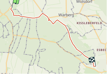
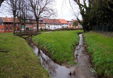
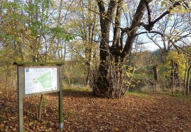
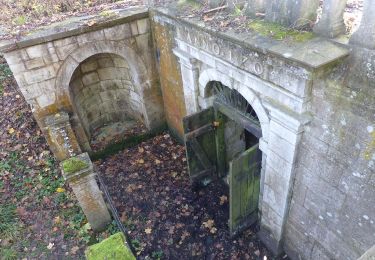
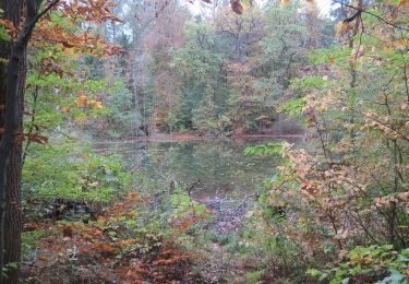
Trail On foot of 10.1 km to be discovered at Lower Saxony, Landkreis Helmstedt, Räbke. This trail is proposed by SityTrail - itinéraires balisés pédestres.
Description
Trail created by Naturpark Elm-Lappwald.
Symbol: stylisierte Wassermühle (rotes Dach [Dreieck mit Schornstein], schwarzer Kreis als Wasserrad, blau-schwarze Welle)
Positioning
Country:
Germany
Region :
Lower Saxony
Department/Province :
Landkreis Helmstedt
Municipality :
Räbke
Location:
Unknown
Start:(Dec)
Start:(UTM)
626909 ; 5783513 (32U) N.
Comments
Trails nearby
![Trail On foot Schöningen - Elmkreisel - Photo](https://media.geolcdn.com/t/375/260/ext.jpg?maxdim=2&url=https%3A%2F%2Fmedia.geolcdn.com%2Ff%2F12247816-37b7-43cb-8585-e0c954f32e78.jpeg)
![On foot On foot](https://static1.geolcdn.com/sitytour/trail-icons/100.png)
Elmkreisel
On foot
Difficult
Schöningen,
Lower Saxony,
Landkreis Helmstedt,
Germany
![](/images/other/stat-length.png)
30 km | 37 km-effort
8h 18min
![](https://static1.geolcdn.com/siteimages/upload/files/16400158638029165_repeat_loop_refresh_sync_direction_icon.png)
No
![Trail On foot Räbke - Zielwanderweg Königslutter Schunterquelle - Photo](https://media.geolcdn.com/t/375/260/ext.jpg?maxdim=2&url=https%3A%2F%2Fmedia.geolcdn.com%2Ff%2F99229cce-47ed-471a-825b-63f657e5f92e.jpeg)
![On foot On foot](https://static1.geolcdn.com/sitytour/trail-icons/100.png)
Zielwanderweg Königslutter Schunterquelle
On foot
Easy
Räbke,
Lower Saxony,
Landkreis Helmstedt,
Germany
![](/images/other/stat-length.png)
6.7 km | 7.9 km-effort
1h 47min
![](https://static1.geolcdn.com/siteimages/upload/files/16400158638029165_repeat_loop_refresh_sync_direction_icon.png)
No
![Trail On foot Schöppenstedt - Elm Rundwanderweg 33 - Photo](https://media.geolcdn.com/t/375/260/ext.jpg?maxdim=2&url=https%3A%2F%2Fmedia.geolcdn.com%2Ff%2F488dd085-e77b-4089-99fa-15a6a0f9c4b7.jpeg)
![On foot On foot](https://static1.geolcdn.com/sitytour/trail-icons/100.png)
Elm Rundwanderweg 33
On foot
Easy
Schöppenstedt,
Lower Saxony,
Landkreis Wolfenbüttel,
Germany
![](/images/other/stat-length.png)
9.4 km | 12 km-effort
2h 43min
![](https://static1.geolcdn.com/siteimages/upload/files/16400158638029165_repeat_loop_refresh_sync_direction_icon.png)
No
![Trail On foot Königslutter am Elm - Zielwanderweg Erkerode-Heinrichsruh - Photo](https://media.geolcdn.com/t/375/260/ext.jpg?maxdim=2&url=https%3A%2F%2Fmedia.geolcdn.com%2Ff%2Fd149467e-e9a7-4319-beea-c6db868f7f50.jpeg)
![On foot On foot](https://static1.geolcdn.com/sitytour/trail-icons/100.png)
Zielwanderweg Erkerode-Heinrichsruh
On foot
Easy
Königslutter am Elm,
Lower Saxony,
Landkreis Helmstedt,
Germany
![](/images/other/stat-length.png)
10.1 km | 12.3 km-effort
2h 47min
![](https://static1.geolcdn.com/siteimages/upload/files/16400158638029165_repeat_loop_refresh_sync_direction_icon.png)
No
![Trail On foot Am Großen Rhode - Elm Rundwanderweg 15 - Photo](https://media.geolcdn.com/t/375/260/ext.jpg?maxdim=2&url=https%3A%2F%2Fmedia.geolcdn.com%2Ff%2Fd1ac1001-cf9a-4030-9535-6b6497ab8f57.jpeg)
![On foot On foot](https://static1.geolcdn.com/sitytour/trail-icons/100.png)
Elm Rundwanderweg 15
On foot
Easy
Am Großen Rhode,
Lower Saxony,
Landkreis Wolfenbüttel,
Germany
![](/images/other/stat-length.png)
4.7 km | 5.6 km-effort
1h 16min
![](https://static1.geolcdn.com/siteimages/upload/files/16400158638029165_repeat_loop_refresh_sync_direction_icon.png)
No
![Trail On foot Räbke - Elm Rundwanderweg 12 - Photo](https://media.geolcdn.com/t/375/260/ext.jpg?maxdim=2&url=https%3A%2F%2Fmedia.geolcdn.com%2Ff%2F12247816-37b7-43cb-8585-e0c954f32e78.jpeg)
![On foot On foot](https://static1.geolcdn.com/sitytour/trail-icons/100.png)
Elm Rundwanderweg 12
On foot
Easy
Räbke,
Lower Saxony,
Landkreis Helmstedt,
Germany
![](/images/other/stat-length.png)
7.5 km | 9.1 km-effort
2h 3min
![](https://static1.geolcdn.com/siteimages/upload/files/16400158638029165_repeat_loop_refresh_sync_direction_icon.png)
Yes
![Trail On foot Räbke - Elm Rundwanderweg 28 - Photo](https://media.geolcdn.com/t/375/260/ext.jpg?maxdim=2&url=https%3A%2F%2Fmedia.geolcdn.com%2Ff%2F12247816-37b7-43cb-8585-e0c954f32e78.jpeg)
![On foot On foot](https://static1.geolcdn.com/sitytour/trail-icons/100.png)
Elm Rundwanderweg 28
On foot
Easy
Räbke,
Lower Saxony,
Landkreis Helmstedt,
Germany
![](/images/other/stat-length.png)
12.5 km | 14.9 km-effort
3h 23min
![](https://static1.geolcdn.com/siteimages/upload/files/16400158638029165_repeat_loop_refresh_sync_direction_icon.png)
Yes
![Trail On foot Königslutter - Elm Rundwanderweg 17 - Photo](https://media.geolcdn.com/t/375/260/ext.jpg?maxdim=2&url=https%3A%2F%2Fmedia.geolcdn.com%2Ff%2Fd149467e-e9a7-4319-beea-c6db868f7f50.jpeg)
![On foot On foot](https://static1.geolcdn.com/sitytour/trail-icons/100.png)
Elm Rundwanderweg 17
On foot
Easy
Königslutter,
Lower Saxony,
Landkreis Helmstedt,
Germany
![](/images/other/stat-length.png)
5.9 km | 7.2 km-effort
1h 37min
![](https://static1.geolcdn.com/siteimages/upload/files/16400158638029165_repeat_loop_refresh_sync_direction_icon.png)
No
![Trail On foot Schöningen - Warburg Rundwanderweg - Photo](https://media.geolcdn.com/t/375/260/ext.jpg?maxdim=2&url=https%3A%2F%2Fmedia.geolcdn.com%2Ff%2Fe5a274b0-1612-4f63-89e9-36e1f5efec5b.jpeg)
![On foot On foot](https://static1.geolcdn.com/sitytour/trail-icons/100.png)
Warburg Rundwanderweg
On foot
Easy
Schöningen,
Lower Saxony,
Landkreis Helmstedt,
Germany
![](/images/other/stat-length.png)
3.1 km | 3.9 km-effort
52min
![](https://static1.geolcdn.com/siteimages/upload/files/16400158638029165_repeat_loop_refresh_sync_direction_icon.png)
No