


5.9 km | 6.9 km-effort
![Trail On foot Unknown - [16] Wanderweg 16 des KEV - Photo](https://media.geolcdn.com/t/1900/400/dec55264-b1c8-453c-bd59-a6135d3846c8.jpeg&format=pjpeg&maxdim=2)

Tous les sentiers balisés d’Europe GUIDE+


FREE GPS app for hiking
 SityTrail
IGN / Geographical institutes
SityTrail World
The world is yours!
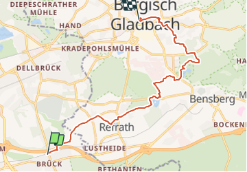
Trail On foot of 12.3 km to be discovered at North Rhine-Westphalia, Cologne, Unknown. This trail is proposed by SityTrail - itinéraires balisés pédestres.
Trail created by Kölner Eifelverein.
Symbol: Gefülltes Dreieck
![Trail On foot Unknown - [16] Wanderweg 16 des KEV - Photo 1](https://media.geolcdn.com/t/2048/auto/f5f4c360-33f3-4175-8969-9f1379e58ee0.jpeg&format=jpg&maxdim=0 "Trail On foot Unknown - [16] Wanderweg 16 des KEV - Photo 1")
![Trail On foot Unknown - [16] Wanderweg 16 des KEV - Photo 2](https://media.geolcdn.com/t/2048/auto/2772daa0-bca9-4690-addd-4bd762cdbbd6.jpeg&format=jpg&maxdim=0 "Trail On foot Unknown - [16] Wanderweg 16 des KEV - Photo 2")
![Trail On foot Unknown - [16] Wanderweg 16 des KEV - Photo 3](https://media.geolcdn.com/t/2048/auto/2a6a2741-7f7b-423d-be54-f6fbb4072b63.jpeg&format=jpg&maxdim=0 "Trail On foot Unknown - [16] Wanderweg 16 des KEV - Photo 3")
![Trail On foot Unknown - [16] Wanderweg 16 des KEV - Photo 4](https://media.geolcdn.com/t/2048/auto/b4334115-bdba-45d8-980a-cce3933e5a4f.jpeg&format=jpg&maxdim=0 "Trail On foot Unknown - [16] Wanderweg 16 des KEV - Photo 4")
![Trail On foot Unknown - [16] Wanderweg 16 des KEV - Photo 5](https://media.geolcdn.com/t/2048/auto/e0cb4ef6-a231-4c32-9e65-8b13ea31a3e1.jpeg&format=jpg&maxdim=0 "Trail On foot Unknown - [16] Wanderweg 16 des KEV - Photo 5")
![Trail On foot Unknown - [16] Wanderweg 16 des KEV - Photo 6](https://media.geolcdn.com/t/2048/auto/afca9f87-10dc-4004-99e6-22243f153d38.jpeg&format=jpg&maxdim=0 "Trail On foot Unknown - [16] Wanderweg 16 des KEV - Photo 6")
![Trail On foot Unknown - [16] Wanderweg 16 des KEV - Photo 7](https://media.geolcdn.com/t/2048/auto/db5adfdb-3830-4e9a-ba62-6eb217097fbe.jpeg&format=jpg&maxdim=0 "Trail On foot Unknown - [16] Wanderweg 16 des KEV - Photo 7")
![Trail On foot Unknown - [16] Wanderweg 16 des KEV - Photo 8](https://media.geolcdn.com/t/2048/auto/2be10ef3-48d1-4723-8526-be6a5e919956.jpeg&format=jpg&maxdim=0 "Trail On foot Unknown - [16] Wanderweg 16 des KEV - Photo 8")
![Trail On foot Unknown - [16] Wanderweg 16 des KEV - Photo 9](https://media.geolcdn.com/t/2048/auto/941c9f71-cde7-4659-a70d-edb7383b02b1.jpeg&format=jpg&maxdim=0 "Trail On foot Unknown - [16] Wanderweg 16 des KEV - Photo 9")
![Trail On foot Unknown - [16] Wanderweg 16 des KEV - Photo 10](https://media.geolcdn.com/t/2048/auto/dec55264-b1c8-453c-bd59-a6135d3846c8.jpeg&format=jpg&maxdim=0 "Trail On foot Unknown - [16] Wanderweg 16 des KEV - Photo 10")
On foot
On foot

On foot