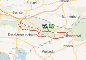
![](/images/other/stat-length.png)
![Trail On foot Auetal - RI5 Drei Burgen Route - Photo](https://media.geolcdn.com/t/1900/400/5e0c6d99-c6ea-4662-96bc-c10b18506f59.jpeg&format=pjpeg&maxdim=2)
RI5 Drei Burgen Route
SityTrail - itinéraires balisés pédestres
Tous les sentiers balisés d’Europe GUIDE+
![Length](/images/other/stat-length.png)
![Max alt](https://static1.geolcdn.com/siteimages/upload/files/1508320355ic_sort_altitude_max_24dp.png)
![Uphill gradient](https://static1.geolcdn.com/siteimages/upload/files/1508320355ic_sort_den_pos_24dp.png)
![Km-Effort](/images/other/stat-length.png)
![Min alt](https://static1.geolcdn.com/siteimages/upload/files/1508320355ic_sort_altitude_min_24dp.png)
![Downhill gradient](https://static1.geolcdn.com/siteimages/upload/files/1508320355ic_sort_den_neg_24dp.png)
![Boucle](https://static1.geolcdn.com/siteimages/upload/files/16400158638029165_repeat_loop_refresh_sync_direction_icon.png)
![On foot](https://static1.geolcdn.com/sitytour/trail-icons/100.png)
4h09
Difficulty : Easy
![Scan this QR Code to open this trail in the SityTrail application](https://capi.geolives.com/qq0zvz2zws4bq2lad0pu/sitytour/trails/3094664/qr.png?size=200)
FREE GPS app for hiking
About
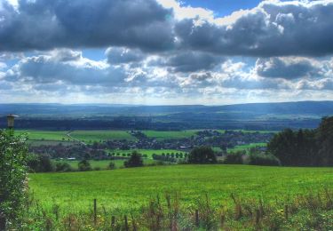
Trail On foot of 13 km to be discovered at Lower Saxony, Landkreis Schaumburg, Auetal. This trail is proposed by SityTrail - itinéraires balisés pédestres.
Description
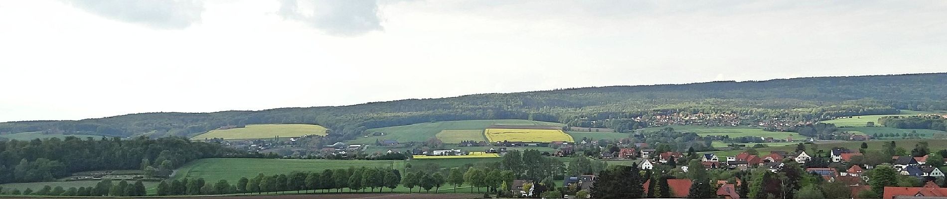
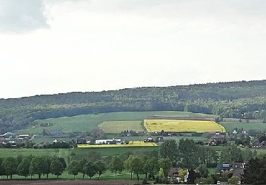
Naturnahe Pfade und Forstwege führen auf dem Höhenzug des Wesergebirges bei Rinteln zu 3 Burgen im Wesergebirge.
Website: https://www.reiseland-niedersachsen.de/drei-burgen-route?lang=
Positioning
Comments
Trails nearby
![Trail On foot Auetal - RI6 Springstein Route - Photo](https://media.geolcdn.com/t/375/260/5e0c6d99-c6ea-4662-96bc-c10b18506f59.jpeg&format=jpg&maxdim=2)
![On foot On foot](https://static1.geolcdn.com/sitytour/trail-icons/100.png)
On foot
![](/images/other/stat-length.png)
![](https://static1.geolcdn.com/siteimages/upload/files/16400158638029165_repeat_loop_refresh_sync_direction_icon.png)
![Trail On foot Auetal - HO1 - Amelungsberg-Route - Photo](https://media.geolcdn.com/t/375/260/dea98733-fca4-4770-ba02-38d9e1c6e490.jpeg&format=jpg&maxdim=2)
![On foot On foot](https://static1.geolcdn.com/sitytour/trail-icons/100.png)
On foot
![](/images/other/stat-length.png)
![](https://static1.geolcdn.com/siteimages/upload/files/16400158638029165_repeat_loop_refresh_sync_direction_icon.png)
![Trail On foot Auetal - RI7 Schloss-Schaumburg Route - Photo](https://media.geolcdn.com/t/375/260/75bfa630-e257-4b54-83f2-882e2b541f2d.jpeg&format=jpg&maxdim=2)
![On foot On foot](https://static1.geolcdn.com/sitytour/trail-icons/100.png)
On foot
![](/images/other/stat-length.png)
![](https://static1.geolcdn.com/siteimages/upload/files/16400158638029165_repeat_loop_refresh_sync_direction_icon.png)
![Trail On foot Auetal - HO2 - Schneegrund-Route - Photo](https://media.geolcdn.com/t/375/260/dea98733-fca4-4770-ba02-38d9e1c6e490.jpeg&format=jpg&maxdim=2)
![On foot On foot](https://static1.geolcdn.com/sitytour/trail-icons/100.png)
On foot
![](/images/other/stat-length.png)
![](https://static1.geolcdn.com/siteimages/upload/files/16400158638029165_repeat_loop_refresh_sync_direction_icon.png)
![Trail On foot Rinteln - RI12 Schlingborn-Route - Photo](https://media.geolcdn.com/t/375/260/dec5a7fd-92ec-4454-b0d0-59b71b39ea43.jpeg&format=jpg&maxdim=2)
![On foot On foot](https://static1.geolcdn.com/sitytour/trail-icons/100.png)
On foot
![](/images/other/stat-length.png)
![](https://static1.geolcdn.com/siteimages/upload/files/16400158638029165_repeat_loop_refresh_sync_direction_icon.png)
![Trail On foot Auetal - RI4 Westendorfer-Egge-Route - Photo](https://media.geolcdn.com/t/375/260/5e0c6d99-c6ea-4662-96bc-c10b18506f59.jpeg&format=jpg&maxdim=2)
![On foot On foot](https://static1.geolcdn.com/sitytour/trail-icons/100.png)
On foot
![](/images/other/stat-length.png)
![](https://static1.geolcdn.com/siteimages/upload/files/16400158638029165_repeat_loop_refresh_sync_direction_icon.png)
![Trail On foot Auetal - AU1 Weg der Selbstzuwendung - Photo](https://media.geolcdn.com/t/375/260/d843dc3f-5eda-461e-a231-23447a0c66eb.jpeg&format=jpg&maxdim=2)
![On foot On foot](https://static1.geolcdn.com/sitytour/trail-icons/100.png)
On foot
![](/images/other/stat-length.png)
![](https://static1.geolcdn.com/siteimages/upload/files/16400158638029165_repeat_loop_refresh_sync_direction_icon.png)
![Trail On foot Rinteln - RI21Rundwanderweg Ludwigsturm - Photo](https://media.geolcdn.com/t/375/260/dec5a7fd-92ec-4454-b0d0-59b71b39ea43.jpeg&format=jpg&maxdim=2)
![On foot On foot](https://static1.geolcdn.com/sitytour/trail-icons/100.png)
On foot
![](/images/other/stat-length.png)
![](https://static1.geolcdn.com/siteimages/upload/files/16400158638029165_repeat_loop_refresh_sync_direction_icon.png)
![Trail On foot Rinteln - RI13 Hünenburg-Route - Photo](https://media.geolcdn.com/t/375/260/ext.jpg?maxdim=2&url=https%3A%2F%2Fstatic1.geolcdn.com%2Fsiteimages%2Fupload%2Ffiles%2F1545311037marcheuse_200dpi.jpg)
![On foot On foot](https://static1.geolcdn.com/sitytour/trail-icons/100.png)
On foot
![](/images/other/stat-length.png)
![](https://static1.geolcdn.com/siteimages/upload/files/16400158638029165_repeat_loop_refresh_sync_direction_icon.png)