


3.7 km | 4.4 km-effort
![Trail On foot Horn-Bad Meinberg - Rundwanderweg A2 [Holzhausen-Externsteine] - Photo](https://media.geolcdn.com/t/1900/400/496f2643-585c-4ec3-ad5f-48d37358ba78.jpeg&format=pjpeg&maxdim=2)

Tous les sentiers balisés d’Europe GUIDE+


FREE GPS app for hiking
 SityTrail
IGN / Geographical institutes
SityTrail World
The world is yours!
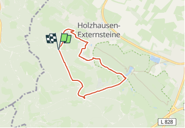
Trail On foot of 5.6 km to be discovered at North Rhine-Westphalia, Kreis Lippe, Horn-Bad Meinberg. This trail is proposed by SityTrail - itinéraires balisés pédestres.
Trail created by Lippischer Heimatbund.
![Trail On foot Horn-Bad Meinberg - Rundwanderweg A2 [Holzhausen-Externsteine] - Photo 1](https://media.geolcdn.com/t/2048/auto/4c5be944-2370-4b32-91d5-3df36f29c7a0.jpeg&format=jpg&maxdim=0 "Trail On foot Horn-Bad Meinberg - Rundwanderweg A2 [Holzhausen-Externsteine] - Photo 1")
![Trail On foot Horn-Bad Meinberg - Rundwanderweg A2 [Holzhausen-Externsteine] - Photo 2](https://media.geolcdn.com/t/2048/auto/64d594ad-822d-4e81-a0c1-fbba8917ba71.jpeg&format=jpg&maxdim=0 "Trail On foot Horn-Bad Meinberg - Rundwanderweg A2 [Holzhausen-Externsteine] - Photo 2")
![Trail On foot Horn-Bad Meinberg - Rundwanderweg A2 [Holzhausen-Externsteine] - Photo 3](https://media.geolcdn.com/t/2048/auto/496f2643-585c-4ec3-ad5f-48d37358ba78.jpeg&format=jpg&maxdim=0 "Trail On foot Horn-Bad Meinberg - Rundwanderweg A2 [Holzhausen-Externsteine] - Photo 3")
![Trail On foot Horn-Bad Meinberg - Rundwanderweg A2 [Holzhausen-Externsteine] - Photo 4](https://media.geolcdn.com/t/2048/auto/2e4a7659-da5b-4bf0-98c0-19ab1c4e2eb4.jpeg&format=jpg&maxdim=0 "Trail On foot Horn-Bad Meinberg - Rundwanderweg A2 [Holzhausen-Externsteine] - Photo 4")
![Trail On foot Horn-Bad Meinberg - Rundwanderweg A2 [Holzhausen-Externsteine] - Photo 5](https://media.geolcdn.com/t/2048/auto/50ef5d41-e1a2-4b7b-818e-0360d6931982.jpeg&format=jpg&maxdim=0 "Trail On foot Horn-Bad Meinberg - Rundwanderweg A2 [Holzhausen-Externsteine] - Photo 5")
![Trail On foot Horn-Bad Meinberg - Rundwanderweg A2 [Holzhausen-Externsteine] - Photo 6](https://media.geolcdn.com/t/2048/auto/944f2969-4df5-4b23-bd79-3dbbfe7201f4.jpeg&format=jpg&maxdim=0 "Trail On foot Horn-Bad Meinberg - Rundwanderweg A2 [Holzhausen-Externsteine] - Photo 6")
![Trail On foot Horn-Bad Meinberg - Rundwanderweg A2 [Holzhausen-Externsteine] - Photo 7](https://media.geolcdn.com/t/2048/auto/c3e74143-5020-407a-9128-45c46aabd324.jpeg&format=jpg&maxdim=0 "Trail On foot Horn-Bad Meinberg - Rundwanderweg A2 [Holzhausen-Externsteine] - Photo 7")
![Trail On foot Horn-Bad Meinberg - Rundwanderweg A2 [Holzhausen-Externsteine] - Photo 8](https://media.geolcdn.com/t/2048/auto/0cf5e179-6115-4b81-bba8-029bc090375a.jpeg&format=jpg&maxdim=0 "Trail On foot Horn-Bad Meinberg - Rundwanderweg A2 [Holzhausen-Externsteine] - Photo 8")
![Trail On foot Horn-Bad Meinberg - Rundwanderweg A2 [Holzhausen-Externsteine] - Photo 9](https://media.geolcdn.com/t/2048/auto/8e5e9429-d8c1-4844-9fef-8f021abf2150.jpeg&format=jpg&maxdim=0 "Trail On foot Horn-Bad Meinberg - Rundwanderweg A2 [Holzhausen-Externsteine] - Photo 9")
![Trail On foot Horn-Bad Meinberg - Rundwanderweg A2 [Holzhausen-Externsteine] - Photo 10](https://media.geolcdn.com/t/2048/auto/f91d4b61-da16-447a-8c54-a3027ff2d541.jpeg&format=jpg&maxdim=0 "Trail On foot Horn-Bad Meinberg - Rundwanderweg A2 [Holzhausen-Externsteine] - Photo 10")
On foot
On foot
![Trail On foot Horn-Bad Meinberg - Rundwanderweg A4 [Feldrom] - Photo](https://media.geolcdn.com/t/375/260/c3e2fda2-4a4b-4515-b251-ad31aeb36002.jpeg&format=jpg&maxdim=2)
On foot
![Trail On foot Detmold - Rundwanderweg A5 [Berlebeck] - Photo](https://media.geolcdn.com/t/375/260/09e96dc8-2a72-420e-af43-8a0b6d458613.jpeg&format=jpg&maxdim=2)
On foot
On foot
On foot
![Trail On foot Horn-Bad Meinberg - Rundwanderweg A1 [Holzhausen-Externsteine] - Photo](https://media.geolcdn.com/t/375/260/917c6440-8043-45d4-9c08-101f3367a522.jpeg&format=jpg&maxdim=2)
On foot
![Trail On foot Detmold - Rundwanderweg [Gauseköte] - Photo](https://media.geolcdn.com/t/375/260/b23ec4a7-b5cb-44c3-a014-f0b25ad95715.jpeg&format=jpg&maxdim=2)
On foot
![Trail On foot Schlangen - Rundwanderweg 34 [Barnacken] - Photo](https://media.geolcdn.com/t/375/260/83e8c965-88dc-4fa7-9331-4da86113c518.jpeg&format=jpg&maxdim=2)
On foot