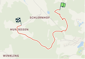
![](/images/other/stat-length.png)
![Trail On foot Falkenstein - Falkensteiner Kräuterweg - Photo](https://media.geolcdn.com/t/1900/400/ext.pjpeg?maxdim=2&url=https%3A%2F%2Fstatic1.geolcdn.com%2Fsiteimages%2Fupload%2Ffiles%2F1545311037marcheuse_200dpi.jpg)
Falkensteiner Kräuterweg
SityTrail - itinéraires balisés pédestres
Tous les sentiers balisés d’Europe GUIDE+
![Length](/images/other/stat-length.png)
![Max alt](https://static1.geolcdn.com/siteimages/upload/files/1508320355ic_sort_altitude_max_24dp.png)
![Uphill gradient](https://static1.geolcdn.com/siteimages/upload/files/1508320355ic_sort_den_pos_24dp.png)
![Km-Effort](/images/other/stat-length.png)
![Min alt](https://static1.geolcdn.com/siteimages/upload/files/1508320355ic_sort_altitude_min_24dp.png)
![Downhill gradient](https://static1.geolcdn.com/siteimages/upload/files/1508320355ic_sort_den_neg_24dp.png)
![Boucle](https://static1.geolcdn.com/siteimages/upload/files/16400158638029165_repeat_loop_refresh_sync_direction_icon.png)
![On foot](https://static1.geolcdn.com/sitytour/trail-icons/100.png)
57m
Difficulty : Easy
![Scan this QR Code to open this trail in the SityTrail application](https://capi.geolives.com/qq0zvz2zws4bq2lad0pu/sitytour/trails/3094476/qr.png?size=200)
FREE GPS app for hiking
About
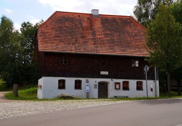
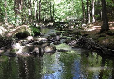
Trail On foot of 3.1 km to be discovered at Bavaria, Landkreis Cham, Falkenstein. This trail is proposed by SityTrail - itinéraires balisés pédestres.
Description
Symbol: Auf einem rechteckigen weißen Grund in Schwarz der Text "Falkensteiner Kräuterweg" mit riesigem "K", hinterlegt mit einem grünen Kräuterzweig und eingekreist von einer grauen Ellipse mit dem Text "Bayerische Kräuterwege".
Positioning
Comments
Trails nearby
![Trail On foot Brennberg - O 53 Höllbachtal - Frauenzell (Grünes Rechteck) - Photo](https://media.geolcdn.com/t/375/260/25632bcf-ab56-47c3-b425-f55cbac61b12.jpeg&format=jpg&maxdim=2)
![On foot On foot](https://static1.geolcdn.com/sitytour/trail-icons/100.png)
On foot
![](/images/other/stat-length.png)
![](https://static1.geolcdn.com/siteimages/upload/files/16400158638029165_repeat_loop_refresh_sync_direction_icon.png)
![Trail On foot Rettenbach - Wilder Mann 149, Naturpark Vorderer Bayerischer Wald - Photo](https://media.geolcdn.com/t/375/260/530773e7-0c8c-4fad-ab0c-c5185028f559.jpeg&format=jpg&maxdim=2)
![On foot On foot](https://static1.geolcdn.com/sitytour/trail-icons/100.png)
On foot
![](/images/other/stat-length.png)
![](https://static1.geolcdn.com/siteimages/upload/files/16400158638029165_repeat_loop_refresh_sync_direction_icon.png)
![Trail On foot Rettenbach - Rundweg Hölle - Photo](https://media.geolcdn.com/t/375/260/341294d3-5eda-4b50-a960-3eb760a86047.jpeg&format=jpg&maxdim=2)
![On foot On foot](https://static1.geolcdn.com/sitytour/trail-icons/100.png)
On foot
![](/images/other/stat-length.png)
![](https://static1.geolcdn.com/siteimages/upload/files/16400158638029165_repeat_loop_refresh_sync_direction_icon.png)
![Trail On foot Falkenstein - Wilder Mann 114 »Mariensteinweg«, Naturpark Vorderer Bayerischer Wald - Photo](https://media.geolcdn.com/t/375/260/ext.jpg?maxdim=2&url=https%3A%2F%2Fstatic1.geolcdn.com%2Fsiteimages%2Fupload%2Ffiles%2F1545311037marcheuse_200dpi.jpg)
![On foot On foot](https://static1.geolcdn.com/sitytour/trail-icons/100.png)
On foot
![](/images/other/stat-length.png)
![](https://static1.geolcdn.com/siteimages/upload/files/16400158638029165_repeat_loop_refresh_sync_direction_icon.png)