Trail On foot Auetal - AU1 Weg der Selbstzuwendung - Photo

AU1 Weg der Selbstzuwendung

Tous les sentiers balisés d’Europe PRO

© OpenStreetMap contributors
Length
Length
4.2 km
Max alt
Max alt
238 m
Uphill gradient
Uphill gradient
73 m
Km-Effort
Km-Effort  
5.1 km
Min alt
Min alt
178 m
Downhill gradient
Downhill gradient
71 m
Boucle
Boucle
Yes
Signpost
Signpost
Creation date :
2022-02-11 15:25:37.056
Updated on :
2022-02-11 15:25:37.056

(0 Reviews)

On foot
On foot
1h09
Difficulty : Easy

Scan this QR Code to open this trail in the SityTrail application

FREE GPS app for hiking

Logo SityTrail SityTrail

IGN / Geographical institutes

Download SityTrail from the App Store Download SityTrail from Google Play

Logo SityTrail SityTrail World

The world is yours!

Download SityTrail from the App Store Download SityTrail from Google Play Download SityTrail on Huawei AppGallery

About

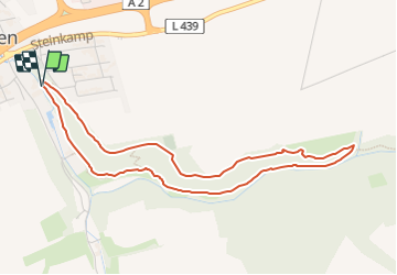
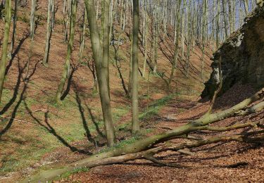
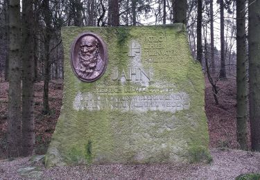
Trail On foot of 4.2 km to be discovered at Lower Saxony, Landkreis Schaumburg, Auetal. This trail is proposed by SityTrail - itinéraires balisés pédestres.

Photos

Positioning

Country:
Germany
Region :
Lower Saxony
Department/Province :
Landkreis Schaumburg
Municipality :
Auetal
Location:
Unknown
Start:(UTM)
516412 ; 5786504 (32U) N.

Trails nearby

Trail On foot Auetal - RI6 Springstein Route - Photo
On foot
PRO

On foot

Easy
Auetal, Lower Saxony, Landkreis Schaumburg, Germany
7 km | 10.1 km-effort
2h 17min
Yes
Trail On foot Auetal - HO1 - Amelungsberg-Route - Photo
On foot
PRO

On foot

Easy
Auetal, Lower Saxony, Landkreis Schaumburg, Germany
5.1 km | 7.2 km-effort
1h 38min
Yes
Trail On foot Auetal - RI7 Schloss-Schaumburg Route - Photo
On foot
PRO

On foot

Easy
Auetal, Lower Saxony, Landkreis Schaumburg, Germany
5.9 km | 8 km-effort
1h 48min
Yes
Trail On foot Auetal - RI5 Drei Burgen Route - Photo
On foot
PRO

On foot

Easy
Auetal, Lower Saxony, Landkreis Schaumburg, Germany
13 km | 18.3 km-effort
4h 9min
Yes
Trail On foot Auetal - HO6 - Blutbach-Route - Photo
On foot
PRO

On foot

Easy
Auetal, Lower Saxony, Landkreis Schaumburg, Germany
3.3 km | 3.9 km-effort
53min
Yes
Trail On foot Auetal - HO2 - Schneegrund-Route - Photo
On foot
PRO

On foot

Easy
Auetal, Lower Saxony, Landkreis Schaumburg, Germany
4.5 km | 6.3 km-effort
1h 25min
No
Trail On foot Auetal - HO8 - Kreuzstein-Route - Photo
On foot
PRO

On foot

Easy
Auetal, Lower Saxony, Landkreis Schaumburg, Germany
7.4 km | 10.4 km-effort
2h 21min
Yes
Trail On foot Auetal - HO7 - Hohenstein Route - Photo
On foot
PRO

On foot

Easy
Auetal, Lower Saxony, Landkreis Schaumburg, Germany
12.2 km | 15.8 km-effort
3h 35min
Yes
Trail On foot Auetal - Naturerlebnispfad Dinosaurierfährten Schaumburger Land - Photo
On foot
PRO

On foot

Easy
Auetal, Lower Saxony, Landkreis Schaumburg, Germany
3.3 km | 3.9 km-effort
52min
Yes


Close
My subscriptions