Trail On foot Obermaiselstein - Beslerrunde - Photo

Tous les sentiers balisés d’Europe GUIDE+

© OpenStreetMap contributors
Length
Length
8.1 km
Max alt
Max alt
1670 m
Uphill gradient
Uphill gradient
557 m
Km-Effort
Km-Effort  
15.6 km
Min alt
Min alt
1185 m
Downhill gradient
Downhill gradient
557 m
Boucle
Boucle
Yes
Signpost
Signpost
Creation date :
2022-02-11 15:24:42.119
Updated on :
2022-02-11 15:24:42.119

(0 Reviews)

On foot
On foot
3h32
Difficulty : Easy

Scan this QR Code to open this trail in the SityTrail application

FREE GPS app for hiking

Logo SityTrail SityTrail

IGN / Geographical institutes

Download SityTrail from the App Store Download SityTrail from Google Play

Logo SityTrail SityTrail World

The world is yours!

Download SityTrail from the App Store Download SityTrail from Google Play Download SityTrail on Huawei AppGallery

About

Trail On foot of 8.1 km to be discovered at Bavaria, Landkreis Oberallgäu, Obermaiselstein. This trail is proposed by SityTrail - itinéraires balisés pédestres.

Description

Trail created by Gemeinde Obermaiselstein.

Kein simples Symbol verfügbar. Auf den Wanderwegweisern wird ein Logo mit der Beschriftung "Naturpark Nagelfluhkette - Premium-Wanderweg Alpin Beslerrunde" in einem grün-violetten Logo verwendet.

Elevation profile

Photos

Positioning

Country:
Germany
Region :
Bavaria
Department/Province :
Landkreis Oberallgäu
Municipality :
Obermaiselstein
Location:
Unknown
Start:(UTM)
590550 ; 5254088 (32T) N.

Trails nearby

Trail On foot Oberstdorf - K - Über Kornau zum Bergkristall - Photo
On foot
GUIDE+

On foot

Easy
Oberstdorf, Bavaria, Landkreis Oberallgäu, Germany
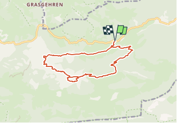
6.4 km | 9.8 km-effort
2h 14min
No
Trail On foot Oberstdorf - Ro - Ins winterliche Rohrmoos - Photo
On foot
GUIDE+

On foot

Easy
Oberstdorf, Bavaria, Landkreis Oberallgäu, Germany
6.4 km | 7.8 km-effort
1h 46min
No
Trail Walking Oberstdorf - Breitachklamm  - Photo
Walking
Geert H.

Walking

Medium
Oberstdorf, Bavaria, Landkreis Oberallgäu, Germany
6.5 km | 11 km-effort
1h 29min
Yes
Trail Walking Oberstdorf - Duitsland - Breitachklamm - Photo
Walking
gpstracks

Walking

Very easy
Oberstdorf, Bavaria, Landkreis Oberallgäu, Germany
4.8 km | 7.9 km-effort
Unknown
Yes
Trail Walking Bolsterlang - Duitsland - Bolsterlang-Ofterschwang - Photo
Walking
gpstracks

Walking

Very easy
Bolsterlang, Bavaria, Landkreis Oberallgäu, Germany
13.5 km | 25 km-effort
Unknown
Yes


Close
My subscriptions