![](/images/other/stat-length.png)
![Trail On foot Sugenheim - Sugenheim Rundweg SU3 - Photo](https://media.geolcdn.com/t/1900/400/13c877e8-48c4-4a8f-94cd-e5a5223f0274.jpeg&format=pjpeg&maxdim=2)
Sugenheim Rundweg SU3
SityTrail - itinéraires balisés pédestres
Tous les sentiers balisés d’Europe GUIDE+
![Length](/images/other/stat-length.png)
Length
12.8 km
![Max alt](https://static1.geolcdn.com/siteimages/upload/files/1508320355ic_sort_altitude_max_24dp.png)
Max alt
446 m
![Uphill gradient](https://static1.geolcdn.com/siteimages/upload/files/1508320355ic_sort_den_pos_24dp.png)
Uphill gradient
200 m
![Km-Effort](/images/other/stat-length.png)
Km-Effort
15.5 km
![Min alt](https://static1.geolcdn.com/siteimages/upload/files/1508320355ic_sort_altitude_min_24dp.png)
Min alt
314 m
![Downhill gradient](https://static1.geolcdn.com/siteimages/upload/files/1508320355ic_sort_den_neg_24dp.png)
Downhill gradient
203 m
![Boucle](https://static1.geolcdn.com/siteimages/upload/files/16400158638029165_repeat_loop_refresh_sync_direction_icon.png)
Boucle
Yes
Signpost
Creation date :
2022-02-11 15:21:31.182
Updated on :
2022-02-11 15:21:31.182
![On foot](https://static1.geolcdn.com/sitytour/trail-icons/100.png)
3h31
Difficulty : Easy
![Scan this QR Code to open this trail in the SityTrail application](https://capi.geolives.com/qq0zvz2zws4bq2lad0pu/sitytour/trails/3094329/qr.png?size=200)
FREE GPS app for hiking
About
Trail On foot of 12.8 km to be discovered at Bavaria, Landkreis Neustadt an der Aisch-Bad Windsheim, Sugenheim. This trail is proposed by SityTrail - itinéraires balisés pédestres.
Description
Trail created by Lokale Aktionsgruppe Südlicher Steigerwald.
Symbol: Roter Text SU3 auf gelbem Grund
Positioning
Country:
Germany
Region :
Bavaria
Department/Province :
Landkreis Neustadt an der Aisch-Bad Windsheim
Municipality :
Sugenheim
Location:
Unknown
Start:(Dec)
Start:(UTM)
600387 ; 5496845 (32U) N.
Comments
Trails nearby
![Trail On foot Markt Nordheim - Wanderweg Blauer Tropfen / Markt Nordheim - Bullenheim - Photo](https://media.geolcdn.com/t/375/260/96dd2e9c-c70e-49f6-9afd-b90b1c81236f.jpeg&format=jpg&maxdim=2)
![On foot On foot](https://static1.geolcdn.com/sitytour/trail-icons/100.png)
Wanderweg Blauer Tropfen / Markt Nordheim - Bullenheim
On foot
Medium
Markt Nordheim,
Bavaria,
Landkreis Neustadt an der Aisch-Bad Windsheim,
Germany
![](/images/other/stat-length.png)
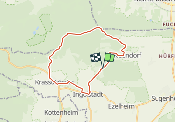
17.4 km | 22 km-effort
5h 0min
![](https://static1.geolcdn.com/siteimages/upload/files/16400158638029165_repeat_loop_refresh_sync_direction_icon.png)
No
![Trail On foot Sugenheim - Sugenheim Rundweg SU12 - Photo](https://media.geolcdn.com/t/375/260/13c877e8-48c4-4a8f-94cd-e5a5223f0274.jpeg&format=jpg&maxdim=2)
![On foot On foot](https://static1.geolcdn.com/sitytour/trail-icons/100.png)
Sugenheim Rundweg SU12
On foot
Easy
Sugenheim,
Bavaria,
Landkreis Neustadt an der Aisch-Bad Windsheim,
Germany
![](/images/other/stat-length.png)
11.9 km | 14.2 km-effort
3h 14min
![](https://static1.geolcdn.com/siteimages/upload/files/16400158638029165_repeat_loop_refresh_sync_direction_icon.png)
Yes