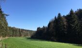
Trail On foot Blankenheim - Eifelschleife Wo Bäche verschwinden - Photo

Eifelschleife Wo Bäche verschwinden

Tous les sentiers balisés d’Europe GUIDE+

© OpenStreetMap contributors
Length
Length
10.4 km
Max alt
Max alt
511 m
Uphill gradient
Uphill gradient
193 m
Km-Effort
Km-Effort  
13 km
Min alt
Min alt
390 m
Downhill gradient
Downhill gradient
193 m
Boucle
Boucle
Yes
Signpost
Signpost
Creation date :
2022-02-11 15:18:09.713
Updated on :
2022-02-11 15:18:09.713

(0 Reviews)

On foot
On foot
2h57
Difficulty : Easy

Scan this QR Code to open this trail in the SityTrail application

FREE GPS app for hiking

Logo SityTrail SityTrail
IGN / Geographical institutes

Download SityTrail from the App Store Download SityTrail from Google Play

Logo SityTrail SityTrail World

The world is yours!

Download SityTrail from the App Store Download SityTrail from Google Play Download SityTrail on Huawei AppGallery

About

Trail On foot of 10.4 km to be discovered at North Rhine-Westphalia, Kreis Euskirchen, Blankenheim. This trail is proposed by SityTrail - itinéraires balisés pédestres.

Description

Trail created by Nordeifel Tourismus GmbH.

Symbol: quadratisches Logo oben blaue Fläche (Himmel) unten grüne Fläche (Berg/Landschaft), unten bis nach oben auf dem Grünen geschlängelt weiße Linie (Weg), oben links in weißer Schrift „EifelSchleifen“

Elevation profile

Photos

Positioning

Country:
Germany
Region :
North Rhine-Westphalia
Department/Province :
Kreis Euskirchen
Municipality :
Blankenheim
Location:
Unknown
Start:(UTM)
333338 ; 5584145 (32U) N.

Trails nearby

Trail On foot Blankenheim - EifelSchleife Über den Brotpfad - Photo
On foot
GUIDE+

On foot

Easy
Blankenheim, North Rhine-Westphalia, Kreis Euskirchen, Germany
12.2 km | 15.6 km-effort
3h 33min
Yes
Trail On foot Blankenheim - EifelSchleife Freilinger See - Photo
On foot
GUIDE+

On foot

Easy
Blankenheim, North Rhine-Westphalia, Kreis Euskirchen, Germany
9.9 km | 12 km-effort
2h 44min
Yes
Trail On foot Blankenheim - EifelSpur Toscana der Eifel - Photo
On foot
GUIDE+

On foot

Medium
Blankenheim, North Rhine-Westphalia, Kreis Euskirchen, Germany
15.3 km | 21 km-effort
4h 42min
Yes
Trail On foot Blankenheim - Oberes Kylltal (4) - Photo
On foot
GUIDE+

On foot

Easy
Blankenheim, North Rhine-Westphalia, Kreis Euskirchen, Germany
7.8 km | 9.7 km-effort
2h 12min
Yes
Trail On foot Jünkerath - Bisselbachtal - Photo
On foot
GUIDE+

On foot

Easy
Jünkerath, Rhineland-Palatinate, Landkreis Vulkaneifel, Germany
5.5 km | 7.5 km-effort
1h 42min
Yes
Trail On foot Blankenheim - Wacholderweg - Photo
On foot
GUIDE+

On foot

Easy
Blankenheim, North Rhine-Westphalia, Kreis Euskirchen, Germany
10.4 km | 13.3 km-effort
3h 1min
No
Trail Walking Blankenheim - Ahrsteig etappe 2 rondwandeling 25km. - Photo
Walking
flip96

Walking

Medium
Blankenheim, North Rhine-Westphalia, Kreis Euskirchen, Germany
23 km | 30 km-effort
6h 47min
Yes
Trail Walking Wiesbaum - ESt-08 - Photo
Walking
hubbi

Walking

Medium
Wiesbaum, Rhineland-Palatinate, Landkreis Vulkaneifel, Germany
25 km | 33 km-effort
6h 53min
No
Trail Other activity Blankenheim - Duitsland - Eifelsteig 06: Ripsdorf - Kerpen - Photo
Other activity
misph

Other activity

Medium
Blankenheim, North Rhine-Westphalia, Kreis Euskirchen, Germany
27 km | 34 km-effort
7h 15min
No


Close
My subscriptions