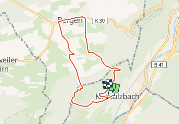
![](/images/other/stat-length.png)
![Trail On foot Kirn - Rundwanderweg Kirn K13 - Photo](https://media.geolcdn.com/t/1900/400/52dec13d-9e2c-44f8-a477-434de24581d9.jpeg&format=pjpeg&maxdim=2)
Rundwanderweg Kirn K13
SityTrail - itinéraires balisés pédestres
Tous les sentiers balisés d’Europe GUIDE+
![Length](/images/other/stat-length.png)
![Max alt](https://static1.geolcdn.com/siteimages/upload/files/1508320355ic_sort_altitude_max_24dp.png)
![Uphill gradient](https://static1.geolcdn.com/siteimages/upload/files/1508320355ic_sort_den_pos_24dp.png)
![Km-Effort](/images/other/stat-length.png)
![Min alt](https://static1.geolcdn.com/siteimages/upload/files/1508320355ic_sort_altitude_min_24dp.png)
![Downhill gradient](https://static1.geolcdn.com/siteimages/upload/files/1508320355ic_sort_den_neg_24dp.png)
![Boucle](https://static1.geolcdn.com/siteimages/upload/files/16400158638029165_repeat_loop_refresh_sync_direction_icon.png)
![On foot](https://static1.geolcdn.com/sitytour/trail-icons/100.png)
2h25
Difficulty : Easy
![Scan this QR Code to open this trail in the SityTrail application](https://capi.geolives.com/qq0zvz2zws4bq2lad0pu/sitytour/trails/3094224/qr.png?size=200)
FREE GPS app for hiking
About
Trail On foot of 7.5 km to be discovered at Rhineland-Palatinate, Landkreis Bad Kreuznach, Kirn. This trail is proposed by SityTrail - itinéraires balisés pédestres.
Description
Symbol: alt: K13 graviert in braune Holzschilder. Zusätzlich neues Symbol: Weißes Schild, oben in schwarz "K13", darunter eine Grafik (Burgturm in Landschaft) mit Text schwarz "Kirn" und blau "Nahe am Leben"
Positioning
Comments
Trails nearby
![Trail On foot Oberhausen bei Kirn - Drei-Burgen-Weg - Photo](https://media.geolcdn.com/t/375/260/6c888f2a-5efb-42e2-b238-e5a63375d933.jpeg&format=jpg&maxdim=2)
![On foot On foot](https://static1.geolcdn.com/sitytour/trail-icons/100.png)
On foot
![](/images/other/stat-length.png)
![](https://static1.geolcdn.com/siteimages/upload/files/16400158638029165_repeat_loop_refresh_sync_direction_icon.png)
![Trail On foot Bärenbach - Vitaltour: Bärenroute - Photo](https://media.geolcdn.com/t/375/260/1d0d7e6f-4964-4069-9267-d5042488d475.jpeg&format=jpg&maxdim=2)
![On foot On foot](https://static1.geolcdn.com/sitytour/trail-icons/100.png)
On foot
![](/images/other/stat-length.png)
![](https://static1.geolcdn.com/siteimages/upload/files/16400158638029165_repeat_loop_refresh_sync_direction_icon.png)
![Trail On foot Bergen - Rundwanderweg Bergen 1 - Photo](https://media.geolcdn.com/t/375/260/75f7cc94-3ade-4c3f-8ac2-2ee2550a7204.jpeg&format=jpg&maxdim=2)
![On foot On foot](https://static1.geolcdn.com/sitytour/trail-icons/100.png)
On foot
![](/images/other/stat-length.png)
![](https://static1.geolcdn.com/siteimages/upload/files/16400158638029165_repeat_loop_refresh_sync_direction_icon.png)
![Trail On foot Bergen - Rundwanderweg Kirn 1 - Photo](https://media.geolcdn.com/t/375/260/75f7cc94-3ade-4c3f-8ac2-2ee2550a7204.jpeg&format=jpg&maxdim=2)
![On foot On foot](https://static1.geolcdn.com/sitytour/trail-icons/100.png)
On foot
![](/images/other/stat-length.png)
![](https://static1.geolcdn.com/siteimages/upload/files/16400158638029165_repeat_loop_refresh_sync_direction_icon.png)
![Trail On foot Idar-Oberstein - Rundweg M3 - Photo](https://media.geolcdn.com/t/375/260/7bf858ff-0361-4ebd-8deb-ba0a4b1de3f3.jpeg&format=jpg&maxdim=2)
![On foot On foot](https://static1.geolcdn.com/sitytour/trail-icons/100.png)
On foot
![](/images/other/stat-length.png)
![](https://static1.geolcdn.com/siteimages/upload/files/16400158638029165_repeat_loop_refresh_sync_direction_icon.png)
![Trail On foot Fischbach - Rundweg E1 - Photo](https://media.geolcdn.com/t/375/260/ext.jpg?maxdim=2&url=https%3A%2F%2Fstatic1.geolcdn.com%2Fsiteimages%2Fupload%2Ffiles%2F1545311037marcheuse_200dpi.jpg)
![On foot On foot](https://static1.geolcdn.com/sitytour/trail-icons/100.png)
On foot
![](/images/other/stat-length.png)
![](https://static1.geolcdn.com/siteimages/upload/files/16400158638029165_repeat_loop_refresh_sync_direction_icon.png)