![](/images/other/stat-length.png)
![Trail On foot Arnsberg - [Dreieck] - Photo](https://media.geolcdn.com/t/1900/400/d81aec76-bcc3-4142-a7ee-5c25b52faed3.jpeg&format=pjpeg&maxdim=2)
[Dreieck]
SityTrail - itinéraires balisés pédestres
Tous les sentiers balisés d’Europe GUIDE+
![Length](/images/other/stat-length.png)
Length
4.3 km
![Max alt](https://static1.geolcdn.com/siteimages/upload/files/1508320355ic_sort_altitude_max_24dp.png)
Max alt
207 m
![Uphill gradient](https://static1.geolcdn.com/siteimages/upload/files/1508320355ic_sort_den_pos_24dp.png)
Uphill gradient
25 m
![Km-Effort](/images/other/stat-length.png)
Km-Effort
4.8 km
![Min alt](https://static1.geolcdn.com/siteimages/upload/files/1508320355ic_sort_altitude_min_24dp.png)
Min alt
150 m
![Downhill gradient](https://static1.geolcdn.com/siteimages/upload/files/1508320355ic_sort_den_neg_24dp.png)
Downhill gradient
79 m
![Boucle](https://static1.geolcdn.com/siteimages/upload/files/16400158638029165_repeat_loop_refresh_sync_direction_icon.png)
Boucle
No
Signpost
Creation date :
2022-02-11 14:44:09.653
Updated on :
2022-02-11 14:44:09.653
![On foot](https://static1.geolcdn.com/sitytour/trail-icons/100.png)
1h06
Difficulty : Easy
![Scan this QR Code to open this trail in the SityTrail application](https://capi.geolives.com/qq0zvz2zws4bq2lad0pu/sitytour/trails/3093196/qr.png?size=200)
FREE GPS app for hiking
About
Trail On foot of 4.3 km to be discovered at North Rhine-Westphalia, Hochsauerlandkreis, Arnsberg. This trail is proposed by SityTrail - itinéraires balisés pédestres.
Description
Trail created by Sauerländischer Gebirgsverein.
Symbol: Weißes ausgefülltes Dreieck auf schwarzem Grund
Positioning
Country:
Germany
Region :
North Rhine-Westphalia
Department/Province :
Hochsauerlandkreis
Municipality :
Arnsberg
Location:
Unknown
Start:(Dec)
Start:(UTM)
422469 ; 5701654 (32U) N.
Comments
Trails nearby
![Trail On foot Arnsberg - V-Weg - Rund um Voßwinkel - Photo](https://media.geolcdn.com/t/375/260/82af1985-47db-46b6-b93f-ea2d12118fe5.jpeg&format=jpg&maxdim=2)
![On foot On foot](https://static1.geolcdn.com/sitytour/trail-icons/100.png)
V-Weg - Rund um Voßwinkel
On foot
Easy
Arnsberg,
North Rhine-Westphalia,
Hochsauerlandkreis,
Germany
![](/images/other/stat-length.png)
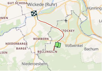
11.4 km | 14.2 km-effort
3h 13min
![](https://static1.geolcdn.com/siteimages/upload/files/16400158638029165_repeat_loop_refresh_sync_direction_icon.png)
Yes
![Trail On foot Ense - Fürstenberg-Rundweg bei Neheim Dreieck - Photo](https://media.geolcdn.com/t/375/260/bd944918-932e-4fb7-82e7-beb10887c35d.jpeg&format=jpg&maxdim=2)
![On foot On foot](https://static1.geolcdn.com/sitytour/trail-icons/100.png)
Fürstenberg-Rundweg bei Neheim Dreieck
On foot
Easy
Ense,
North Rhine-Westphalia,
Kreis Soest,
Germany
![](/images/other/stat-length.png)
4.8 km | 7 km-effort
1h 34min
![](https://static1.geolcdn.com/siteimages/upload/files/16400158638029165_repeat_loop_refresh_sync_direction_icon.png)
No
![Trail On foot Menden - [A7] im Stadtwald Neheim - Photo](https://media.geolcdn.com/t/375/260/1df3787c-7ea3-4687-aebc-0b7544580bac.jpeg&format=jpg&maxdim=2)
![On foot On foot](https://static1.geolcdn.com/sitytour/trail-icons/100.png)
[A7] im Stadtwald Neheim
On foot
Easy
Menden,
North Rhine-Westphalia,
Märkischer Kreis,
Germany
![](/images/other/stat-length.png)
3.3 km | 3.9 km-effort
53min
![](https://static1.geolcdn.com/siteimages/upload/files/16400158638029165_repeat_loop_refresh_sync_direction_icon.png)
No
![Trail On foot Menden - [A8] im Stadtwald Neheim - Photo](https://media.geolcdn.com/t/375/260/2d66c466-b78f-43e0-bcea-e76d5a8507c4.jpeg&format=jpg&maxdim=2)
![On foot On foot](https://static1.geolcdn.com/sitytour/trail-icons/100.png)
[A8] im Stadtwald Neheim
On foot
Easy
Menden,
North Rhine-Westphalia,
Märkischer Kreis,
Germany
![](/images/other/stat-length.png)
11.2 km | 14.4 km-effort
3h 16min
![](https://static1.geolcdn.com/siteimages/upload/files/16400158638029165_repeat_loop_refresh_sync_direction_icon.png)
No
![Trail On foot Arnsberg - [Quadrat] Luerwald Rundweg - Photo](https://media.geolcdn.com/t/375/260/956801ea-cad4-4d8d-ac8e-4517bcdfc5db.jpeg&format=jpg&maxdim=2)
![On foot On foot](https://static1.geolcdn.com/sitytour/trail-icons/100.png)
[Quadrat] Luerwald Rundweg
On foot
Easy
Arnsberg,
North Rhine-Westphalia,
Hochsauerlandkreis,
Germany
![](/images/other/stat-length.png)
5.5 km | 6.8 km-effort
1h 33min
![](https://static1.geolcdn.com/siteimages/upload/files/16400158638029165_repeat_loop_refresh_sync_direction_icon.png)
No
![Trail On foot Arnsberg - Im Luerwald bei Neheim A4 - Photo](https://media.geolcdn.com/t/375/260/956801ea-cad4-4d8d-ac8e-4517bcdfc5db.jpeg&format=jpg&maxdim=2)
![On foot On foot](https://static1.geolcdn.com/sitytour/trail-icons/100.png)
Im Luerwald bei Neheim A4
On foot
Easy
Arnsberg,
North Rhine-Westphalia,
Hochsauerlandkreis,
Germany
![](/images/other/stat-length.png)
7.3 km | 9.3 km-effort
2h 7min
![](https://static1.geolcdn.com/siteimages/upload/files/16400158638029165_repeat_loop_refresh_sync_direction_icon.png)
Yes
![Trail On foot Arnsberg - Im Luerwald bei Neheim A3 - Photo](https://media.geolcdn.com/t/375/260/956801ea-cad4-4d8d-ac8e-4517bcdfc5db.jpeg&format=jpg&maxdim=2)
![On foot On foot](https://static1.geolcdn.com/sitytour/trail-icons/100.png)
Im Luerwald bei Neheim A3
On foot
Easy
Arnsberg,
North Rhine-Westphalia,
Hochsauerlandkreis,
Germany
![](/images/other/stat-length.png)
9.1 km | 12 km-effort
2h 43min
![](https://static1.geolcdn.com/siteimages/upload/files/16400158638029165_repeat_loop_refresh_sync_direction_icon.png)
Yes
![Trail On foot Arnsberg - Im Luerwald bei Neheim A2 - Photo](https://media.geolcdn.com/t/375/260/956801ea-cad4-4d8d-ac8e-4517bcdfc5db.jpeg&format=jpg&maxdim=2)
![On foot On foot](https://static1.geolcdn.com/sitytour/trail-icons/100.png)
Im Luerwald bei Neheim A2
On foot
Easy
Arnsberg,
North Rhine-Westphalia,
Hochsauerlandkreis,
Germany
![](/images/other/stat-length.png)
5.3 km | 7 km-effort
1h 35min
![](https://static1.geolcdn.com/siteimages/upload/files/16400158638029165_repeat_loop_refresh_sync_direction_icon.png)
Yes
![Trail On foot Arnsberg - Im Luerwald bei Neheim A1 - Photo](https://media.geolcdn.com/t/375/260/956801ea-cad4-4d8d-ac8e-4517bcdfc5db.jpeg&format=jpg&maxdim=2)
![On foot On foot](https://static1.geolcdn.com/sitytour/trail-icons/100.png)
Im Luerwald bei Neheim A1
On foot
Easy
Arnsberg,
North Rhine-Westphalia,
Hochsauerlandkreis,
Germany
![](/images/other/stat-length.png)
5.5 km | 7.3 km-effort
1h 39min
![](https://static1.geolcdn.com/siteimages/upload/files/16400158638029165_repeat_loop_refresh_sync_direction_icon.png)
Yes