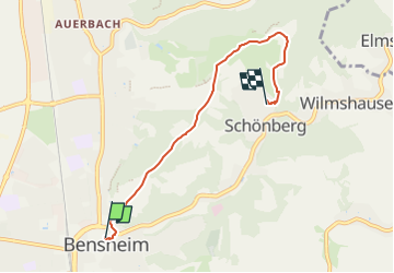
![](/images/other/stat-length.png)
![Trail On foot Bensheim - Franziskanischer Pilgerweg Bensheim - Photo](https://media.geolcdn.com/t/1900/400/970a4d92-64ad-49c4-bc9f-0b3eac488335.jpeg&format=pjpeg&maxdim=2)
Franziskanischer Pilgerweg Bensheim
SityTrail - itinéraires balisés pédestres
Tous les sentiers balisés d’Europe GUIDE+
![Length](/images/other/stat-length.png)
![Max alt](https://static1.geolcdn.com/siteimages/upload/files/1508320355ic_sort_altitude_max_24dp.png)
![Uphill gradient](https://static1.geolcdn.com/siteimages/upload/files/1508320355ic_sort_den_pos_24dp.png)
![Km-Effort](/images/other/stat-length.png)
![Min alt](https://static1.geolcdn.com/siteimages/upload/files/1508320355ic_sort_altitude_min_24dp.png)
![Downhill gradient](https://static1.geolcdn.com/siteimages/upload/files/1508320355ic_sort_den_neg_24dp.png)
![Boucle](https://static1.geolcdn.com/siteimages/upload/files/16400158638029165_repeat_loop_refresh_sync_direction_icon.png)
![On foot](https://static1.geolcdn.com/sitytour/trail-icons/100.png)
1h30
Difficulty : Easy
![Scan this QR Code to open this trail in the SityTrail application](https://capi.geolives.com/qq0zvz2zws4bq2lad0pu/sitytour/trails/3093173/qr.png?size=200)
FREE GPS app for hiking
About
Trail On foot of 4.6 km to be discovered at Hesse, Kreis Bergstraße, Bensheim. This trail is proposed by SityTrail - itinéraires balisés pédestres.
Description
Trail created by Franziskanische Gemeinschaft Bensheim.
ein Pilgerführer liegt in der Klosterkirche aus
Symbol: dunkelbraunes T (Tau) auf weißem Kreis mit dunkelbraunem Rand
Website: https://www.franziskaner-bensheim.de/pilgerweg/
Positioning
Comments
Trails nearby
![Trail On foot Einhausen - Rundwanderweg Lorsch Teschenauer Berg 2: Gewässer-Lehrpfad - Photo](https://media.geolcdn.com/t/375/260/efffb722-a096-4bfd-b5bb-fabea87a385b.jpeg&format=jpg&maxdim=2)
![On foot On foot](https://static1.geolcdn.com/sitytour/trail-icons/100.png)
On foot
![](/images/other/stat-length.png)
![](https://static1.geolcdn.com/siteimages/upload/files/16400158638029165_repeat_loop_refresh_sync_direction_icon.png)
![Trail On foot Heppenheim - Rundwanderweg Heppenheim 5: Weinblickweg - Photo](https://media.geolcdn.com/t/375/260/fcb4f804-5c76-49bb-8489-4244983d58e2.jpeg&format=jpg&maxdim=2)
![On foot On foot](https://static1.geolcdn.com/sitytour/trail-icons/100.png)
On foot
![](/images/other/stat-length.png)
![](https://static1.geolcdn.com/siteimages/upload/files/16400158638029165_repeat_loop_refresh_sync_direction_icon.png)
![Trail On foot Heppenheim - Rundwanderweg Heppenheim Starkenburg 3: Hambacher Grenzweg - Photo](https://media.geolcdn.com/t/375/260/a76ad390-e1f5-434e-8b18-5ea518b32ea0.jpeg&format=jpg&maxdim=2)
![On foot On foot](https://static1.geolcdn.com/sitytour/trail-icons/100.png)
On foot
![](/images/other/stat-length.png)
![](https://static1.geolcdn.com/siteimages/upload/files/16400158638029165_repeat_loop_refresh_sync_direction_icon.png)
![Trail On foot Heppenheim - Rundwanderweg Heppenheim 4: Maiberg-Weg - Photo](https://media.geolcdn.com/t/375/260/56021295-55a0-4077-8cb8-7d346b71da92.jpeg&format=jpg&maxdim=2)
![On foot On foot](https://static1.geolcdn.com/sitytour/trail-icons/100.png)
On foot
![](/images/other/stat-length.png)
![](https://static1.geolcdn.com/siteimages/upload/files/16400158638029165_repeat_loop_refresh_sync_direction_icon.png)
![Trail On foot Lautertal - Rundwanderweg Reichenbach 4: Hohenstein-Weg - Photo](https://media.geolcdn.com/t/375/260/8c604800-80b3-45bf-8444-cd2ff2dc9c5f.jpeg&format=jpg&maxdim=2)
![On foot On foot](https://static1.geolcdn.com/sitytour/trail-icons/100.png)
On foot
![](/images/other/stat-length.png)
![](https://static1.geolcdn.com/siteimages/upload/files/16400158638029165_repeat_loop_refresh_sync_direction_icon.png)
![Trail On foot Lautertal - Rundwanderweg Reichenbach 2: Höll-Berg-Weg - Photo](https://media.geolcdn.com/t/375/260/e21677ac-3ecb-4201-8088-c0dc6c5ccdb2.jpeg&format=jpg&maxdim=2)
![On foot On foot](https://static1.geolcdn.com/sitytour/trail-icons/100.png)
On foot
![](/images/other/stat-length.png)
![](https://static1.geolcdn.com/siteimages/upload/files/16400158638029165_repeat_loop_refresh_sync_direction_icon.png)
![Trail On foot Lautertal - Rundwanderweg Lautertal 3 - Photo](https://media.geolcdn.com/t/375/260/b0dbbc98-a994-4550-8c2e-468da76e5660.jpeg&format=jpg&maxdim=2)
![On foot On foot](https://static1.geolcdn.com/sitytour/trail-icons/100.png)
On foot
![](/images/other/stat-length.png)
![](https://static1.geolcdn.com/siteimages/upload/files/16400158638029165_repeat_loop_refresh_sync_direction_icon.png)
![Trail On foot Lautertal - Rundwanderweg Reichenbach 3: Borstein-Weg - Photo](https://media.geolcdn.com/t/375/260/b0dbbc98-a994-4550-8c2e-468da76e5660.jpeg&format=jpg&maxdim=2)
![On foot On foot](https://static1.geolcdn.com/sitytour/trail-icons/100.png)
On foot
![](/images/other/stat-length.png)
![](https://static1.geolcdn.com/siteimages/upload/files/16400158638029165_repeat_loop_refresh_sync_direction_icon.png)
![Trail On foot Bensheim - Rundwanderweg Bensheim Am Höllberg 2: Goldkauf-Weg - Photo](https://media.geolcdn.com/t/375/260/c27cab7f-5605-40fd-9add-5857489b9349.jpeg&format=jpg&maxdim=2)
![On foot On foot](https://static1.geolcdn.com/sitytour/trail-icons/100.png)
On foot
![](/images/other/stat-length.png)
![](https://static1.geolcdn.com/siteimages/upload/files/16400158638029165_repeat_loop_refresh_sync_direction_icon.png)