![](/images/other/stat-length.png)
![Trail On foot Kelkheim - Rund um den Rettershof: Weg 9 - Photo](https://media.geolcdn.com/t/1900/400/d60e7ac4-a9eb-4204-8b05-640272e8ca0b.jpeg&format=pjpeg&maxdim=2)
Rund um den Rettershof: Weg 9
SityTrail - itinéraires balisés pédestres
Tous les sentiers balisés d’Europe GUIDE+
![Length](/images/other/stat-length.png)
![Max alt](https://static1.geolcdn.com/siteimages/upload/files/1508320355ic_sort_altitude_max_24dp.png)
![Uphill gradient](https://static1.geolcdn.com/siteimages/upload/files/1508320355ic_sort_den_pos_24dp.png)
![Km-Effort](/images/other/stat-length.png)
![Min alt](https://static1.geolcdn.com/siteimages/upload/files/1508320355ic_sort_altitude_min_24dp.png)
![Downhill gradient](https://static1.geolcdn.com/siteimages/upload/files/1508320355ic_sort_den_neg_24dp.png)
![Boucle](https://static1.geolcdn.com/siteimages/upload/files/16400158638029165_repeat_loop_refresh_sync_direction_icon.png)
![On foot](https://static1.geolcdn.com/sitytour/trail-icons/100.png)
1h22
Difficulty : Easy
![Scan this QR Code to open this trail in the SityTrail application](https://capi.geolives.com/qq0zvz2zws4bq2lad0pu/sitytour/trails/3093116/qr.png?size=200)
FREE GPS app for hiking
About
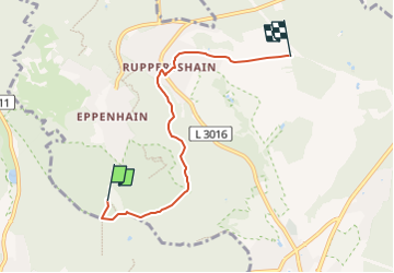
Trail On foot of 4.6 km to be discovered at Hesse, Main-Taunus-Kreis, Kelkheim. This trail is proposed by SityTrail - itinéraires balisés pédestres.
Description
Trail created by Taunusklub.
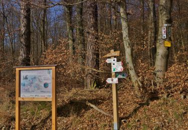
Symbol: Grüner Kreis, darin links ein rotes R, rechts eine rote 9 und mittig das Taunusclub-Symbol in grün, überschrieben mit Rundwanderweg. Unterhalb des Kreises der Text "Rund um den Rettershof"
Positioning
Comments
Trails nearby
![Trail On foot Niedernhausen - Apfelwein- & Obstwiesenroute - Photo](https://media.geolcdn.com/t/375/260/87dc28d5-eff7-4607-8859-08f5f63fa20a.jpeg&format=jpg&maxdim=2)
![On foot On foot](https://static1.geolcdn.com/sitytour/trail-icons/100.png)
On foot
![](/images/other/stat-length.png)
![](https://static1.geolcdn.com/siteimages/upload/files/16400158638029165_repeat_loop_refresh_sync_direction_icon.png)
![Trail On foot Niedernhausen - Waldinfo-Pfad - Photo](https://media.geolcdn.com/t/375/260/aabdab6a-1c6c-469f-b931-7870c4b794bd.jpeg&format=jpg&maxdim=2)
![On foot On foot](https://static1.geolcdn.com/sitytour/trail-icons/100.png)
On foot
![](/images/other/stat-length.png)
![](https://static1.geolcdn.com/siteimages/upload/files/16400158638029165_repeat_loop_refresh_sync_direction_icon.png)
![Trail On foot Niedernhausen - Gusbacher Strandweg - Photo](https://media.geolcdn.com/t/375/260/d1e75f9a-a19f-4ee6-9b66-06eae109953e.jpeg&format=jpg&maxdim=2)
![On foot On foot](https://static1.geolcdn.com/sitytour/trail-icons/100.png)
On foot
![](/images/other/stat-length.png)
![](https://static1.geolcdn.com/siteimages/upload/files/16400158638029165_repeat_loop_refresh_sync_direction_icon.png)
![Trail On foot Eppstein - Bauwaldfels: Geweih - Photo](https://media.geolcdn.com/t/375/260/e819c04a-2838-4852-bdcd-c0c51534d926.jpeg&format=jpg&maxdim=2)
![On foot On foot](https://static1.geolcdn.com/sitytour/trail-icons/100.png)
On foot
![](/images/other/stat-length.png)
![](https://static1.geolcdn.com/siteimages/upload/files/16400158638029165_repeat_loop_refresh_sync_direction_icon.png)
![Trail On foot Niedernhausen - Alteburger Marktweg - Photo](https://media.geolcdn.com/t/375/260/b9dd35eb-0099-4158-b5fc-7aecd5b4e31e.jpeg&format=jpg&maxdim=2)
![On foot On foot](https://static1.geolcdn.com/sitytour/trail-icons/100.png)
On foot
![](/images/other/stat-length.png)
![](https://static1.geolcdn.com/siteimages/upload/files/16400158638029165_repeat_loop_refresh_sync_direction_icon.png)
![Trail On foot Niedernhausen - Lindenkopf: Eichhorn - Photo](https://media.geolcdn.com/t/375/260/aabdab6a-1c6c-469f-b931-7870c4b794bd.jpeg&format=jpg&maxdim=2)
![On foot On foot](https://static1.geolcdn.com/sitytour/trail-icons/100.png)
On foot
![](/images/other/stat-length.png)
![](https://static1.geolcdn.com/siteimages/upload/files/16400158638029165_repeat_loop_refresh_sync_direction_icon.png)
![Trail On foot Niedernhausen - Lindenkopf: Rehbock - Photo](https://media.geolcdn.com/t/375/260/045cbb78-26a0-4d3e-97a1-e0fd979e1346.jpeg&format=jpg&maxdim=2)
![On foot On foot](https://static1.geolcdn.com/sitytour/trail-icons/100.png)
On foot
![](/images/other/stat-length.png)
![](https://static1.geolcdn.com/siteimages/upload/files/16400158638029165_repeat_loop_refresh_sync_direction_icon.png)
![Trail On foot Niedernhausen - Lindenkopf: Fichte - Photo](https://media.geolcdn.com/t/375/260/174095ab-1dbb-4c0d-b88a-c865fdc12ef3.jpeg&format=jpg&maxdim=2)
![On foot On foot](https://static1.geolcdn.com/sitytour/trail-icons/100.png)
On foot
![](/images/other/stat-length.png)
![](https://static1.geolcdn.com/siteimages/upload/files/16400158638029165_repeat_loop_refresh_sync_direction_icon.png)
![Trail On foot Niedernhausen - Geo-Erlebnispfad Oberjosbach - Photo](https://media.geolcdn.com/t/375/260/87b69078-379d-492e-ae13-d0474ce717f0.jpeg&format=jpg&maxdim=2)
![On foot On foot](https://static1.geolcdn.com/sitytour/trail-icons/100.png)
On foot
![](/images/other/stat-length.png)
![](https://static1.geolcdn.com/siteimages/upload/files/16400158638029165_repeat_loop_refresh_sync_direction_icon.png)