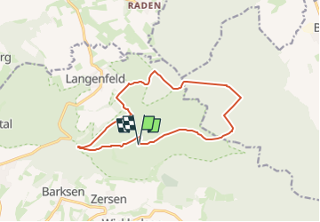
![](/images/other/stat-length.png)
![Trail On foot Auetal - HO7 - Hohenstein Route - Photo](https://media.geolcdn.com/t/1900/400/1aeb67ea-79b2-489e-ad6a-b72fa034a647.jpeg&format=pjpeg&maxdim=2)
HO7 - Hohenstein Route
SityTrail - itinéraires balisés pédestres
Tous les sentiers balisés d’Europe GUIDE+
![Length](/images/other/stat-length.png)
![Max alt](https://static1.geolcdn.com/siteimages/upload/files/1508320355ic_sort_altitude_max_24dp.png)
![Uphill gradient](https://static1.geolcdn.com/siteimages/upload/files/1508320355ic_sort_den_pos_24dp.png)
![Km-Effort](/images/other/stat-length.png)
![Min alt](https://static1.geolcdn.com/siteimages/upload/files/1508320355ic_sort_altitude_min_24dp.png)
![Downhill gradient](https://static1.geolcdn.com/siteimages/upload/files/1508320355ic_sort_den_neg_24dp.png)
![Boucle](https://static1.geolcdn.com/siteimages/upload/files/16400158638029165_repeat_loop_refresh_sync_direction_icon.png)
![On foot](https://static1.geolcdn.com/sitytour/trail-icons/100.png)
3h35
Difficulty : Easy
![Scan this QR Code to open this trail in the SityTrail application](https://capi.geolives.com/qq0zvz2zws4bq2lad0pu/sitytour/trails/3093034/qr.png?size=200)
FREE GPS app for hiking
About
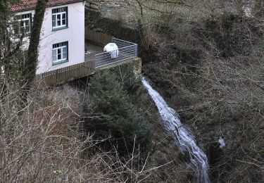
Trail On foot of 12.2 km to be discovered at Lower Saxony, Landkreis Schaumburg, Auetal. This trail is proposed by SityTrail - itinéraires balisés pédestres.
Description
Die komplett ausgeschilderten Rundwanderwege im Westlichen Weserbergland eignen sich gut für Tageswanderungen und Tagesausflüge.
Website: https://www.westliches-weserbergland.de/die-wanderregion/fern-und-rundwanderwege/rundwanderwege#/de/westliches-weserbergland_neu/default/detail/Tour/5EE3C0485C0525629E5A5160BCC2F73E/ho7-hohenstein-route
Positioning
Comments
Trails nearby
![Trail On foot Auetal - HO12 - Süntelturm-Route - Photo](https://media.geolcdn.com/t/375/260/2922a719-4545-414c-b6ba-5c913f4145d2.jpeg&format=jpg&maxdim=2)
![On foot On foot](https://static1.geolcdn.com/sitytour/trail-icons/100.png)
On foot
![](/images/other/stat-length.png)
![](https://static1.geolcdn.com/siteimages/upload/files/16400158638029165_repeat_loop_refresh_sync_direction_icon.png)
![Trail On foot Auetal - HO1 - Amelungsberg-Route - Photo](https://media.geolcdn.com/t/375/260/dea98733-fca4-4770-ba02-38d9e1c6e490.jpeg&format=jpg&maxdim=2)
![On foot On foot](https://static1.geolcdn.com/sitytour/trail-icons/100.png)
On foot
![](/images/other/stat-length.png)
![](https://static1.geolcdn.com/siteimages/upload/files/16400158638029165_repeat_loop_refresh_sync_direction_icon.png)
![Trail On foot Auetal - HO6 - Blutbach-Route - Photo](https://media.geolcdn.com/t/375/260/e3201841-b8b9-475b-a2c8-5b835b6e5123.jpeg&format=jpg&maxdim=2)
![On foot On foot](https://static1.geolcdn.com/sitytour/trail-icons/100.png)
On foot
![](/images/other/stat-length.png)
![](https://static1.geolcdn.com/siteimages/upload/files/16400158638029165_repeat_loop_refresh_sync_direction_icon.png)
![Trail On foot Auetal - HO9 - Roter Stein Route - Photo](https://media.geolcdn.com/t/375/260/3751a573-1cdd-4794-939d-32d5e931bbe4.jpeg&format=jpg&maxdim=2)
![On foot On foot](https://static1.geolcdn.com/sitytour/trail-icons/100.png)
On foot
![](/images/other/stat-length.png)
![](https://static1.geolcdn.com/siteimages/upload/files/16400158638029165_repeat_loop_refresh_sync_direction_icon.png)
![Trail On foot Auetal - HO10 - Westerberg-Route - Photo](https://media.geolcdn.com/t/375/260/82c13ff5-a670-47a7-a589-3be5522360a6.jpeg&format=jpg&maxdim=2)
![On foot On foot](https://static1.geolcdn.com/sitytour/trail-icons/100.png)
On foot
![](/images/other/stat-length.png)
![](https://static1.geolcdn.com/siteimages/upload/files/16400158638029165_repeat_loop_refresh_sync_direction_icon.png)
![Trail On foot Auetal - HO2 - Schneegrund-Route - Photo](https://media.geolcdn.com/t/375/260/dea98733-fca4-4770-ba02-38d9e1c6e490.jpeg&format=jpg&maxdim=2)
![On foot On foot](https://static1.geolcdn.com/sitytour/trail-icons/100.png)
On foot
![](/images/other/stat-length.png)
![](https://static1.geolcdn.com/siteimages/upload/files/16400158638029165_repeat_loop_refresh_sync_direction_icon.png)
![Trail On foot Auetal - HO8 - Kreuzstein-Route - Photo](https://media.geolcdn.com/t/375/260/1aeb67ea-79b2-489e-ad6a-b72fa034a647.jpeg&format=jpg&maxdim=2)
![On foot On foot](https://static1.geolcdn.com/sitytour/trail-icons/100.png)
On foot
![](/images/other/stat-length.png)
![](https://static1.geolcdn.com/siteimages/upload/files/16400158638029165_repeat_loop_refresh_sync_direction_icon.png)
![Trail On foot Auetal - HO5 - Langenfeld Route - Photo](https://media.geolcdn.com/t/375/260/64e0f277-d2b2-4ece-87d7-2158c7e434cc.jpeg&format=jpg&maxdim=2)
![On foot On foot](https://static1.geolcdn.com/sitytour/trail-icons/100.png)
On foot
![](/images/other/stat-length.png)
![](https://static1.geolcdn.com/siteimages/upload/files/16400158638029165_repeat_loop_refresh_sync_direction_icon.png)
![Trail On foot Auetal - AU1 Weg der Selbstzuwendung - Photo](https://media.geolcdn.com/t/375/260/d843dc3f-5eda-461e-a231-23447a0c66eb.jpeg&format=jpg&maxdim=2)
![On foot On foot](https://static1.geolcdn.com/sitytour/trail-icons/100.png)
On foot
![](/images/other/stat-length.png)
![](https://static1.geolcdn.com/siteimages/upload/files/16400158638029165_repeat_loop_refresh_sync_direction_icon.png)