![](/images/other/stat-length.png)
![Trail On foot Thanstein - Thanstein-Bauhof-Weg](https://media.geolcdn.com/t/1900/400/1b793e07-7979-45a2-b2ee-2247369056e3.jpeg&format=pjpeg&maxdim=2)
Thanstein-Bauhof-Weg "T3"
SityTrail - itinéraires balisés pédestres
Tous les sentiers balisés d’Europe GUIDE+
![Length](/images/other/stat-length.png)
Length
6.6 km
![Max alt](https://static1.geolcdn.com/siteimages/upload/files/1508320355ic_sort_altitude_max_24dp.png)
Max alt
711 m
![Uphill gradient](https://static1.geolcdn.com/siteimages/upload/files/1508320355ic_sort_den_pos_24dp.png)
Uphill gradient
243 m
![Km-Effort](/images/other/stat-length.png)
Km-Effort
9.8 km
![Min alt](https://static1.geolcdn.com/siteimages/upload/files/1508320355ic_sort_altitude_min_24dp.png)
Min alt
537 m
![Downhill gradient](https://static1.geolcdn.com/siteimages/upload/files/1508320355ic_sort_den_neg_24dp.png)
Downhill gradient
216 m
![Boucle](https://static1.geolcdn.com/siteimages/upload/files/16400158638029165_repeat_loop_refresh_sync_direction_icon.png)
Boucle
No
Signpost
Creation date :
2022-02-11 14:32:20.812
Updated on :
2022-02-11 14:32:20.812
![On foot](https://static1.geolcdn.com/sitytour/trail-icons/100.png)
2h12
Difficulty : Easy
![Scan this QR Code to open this trail in the SityTrail application](https://capi.geolives.com/qq0zvz2zws4bq2lad0pu/sitytour/trails/3092785/qr.png?size=200)
FREE GPS app for hiking
About
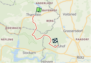
Trail On foot of 6.6 km to be discovered at Bavaria, Landkreis Schwandorf, Thanstein. This trail is proposed by SityTrail - itinéraires balisés pédestres.
Description
Trail created by Verwaltungsgem. Neunburg v. Wald.
Symbol: Rechteckiger gelber Hintergrund (Querformat) mit schwarzer Wegnummer
Positioning
Country:
Germany
Region :
Bavaria
Department/Province :
Landkreis Schwandorf
Municipality :
Thanstein
Location:
Unknown
Start:(Dec)
Start:(UTM)
316416 ; 5472686 (33U) N.
Comments
Trails nearby
![Trail On foot Thanstein - Moosweg - Photo](https://media.geolcdn.com/t/375/260/1b793e07-7979-45a2-b2ee-2247369056e3.jpeg&format=jpg&maxdim=2)
![On foot On foot](https://static1.geolcdn.com/sitytour/trail-icons/100.png)
Moosweg
On foot
Easy
Thanstein,
Bavaria,
Landkreis Schwandorf,
Germany
![](/images/other/stat-length.png)
7.9 km | 10.1 km-effort
2h 18min
![](https://static1.geolcdn.com/siteimages/upload/files/16400158638029165_repeat_loop_refresh_sync_direction_icon.png)
No
![Trail On foot Thanstein - Kaisereichenweg - Photo](https://media.geolcdn.com/t/375/260/cda28eb4-819a-4750-a893-aa0bfcb85ab1.jpeg&format=jpg&maxdim=2)
![On foot On foot](https://static1.geolcdn.com/sitytour/trail-icons/100.png)
Kaisereichenweg
On foot
Easy
Thanstein,
Bavaria,
Landkreis Schwandorf,
Germany
![](/images/other/stat-length.png)
5.4 km | 7.3 km-effort
1h 39min
![](https://static1.geolcdn.com/siteimages/upload/files/16400158638029165_repeat_loop_refresh_sync_direction_icon.png)
No
![Trail On foot Thanstein - Mühlweiherweg](https://media.geolcdn.com/t/375/260/1b793e07-7979-45a2-b2ee-2247369056e3.jpeg&format=jpg&maxdim=2)
![On foot On foot](https://static1.geolcdn.com/sitytour/trail-icons/100.png)
Mühlweiherweg "T 8"
On foot
Easy
Thanstein,
Bavaria,
Landkreis Schwandorf,
Germany
![](/images/other/stat-length.png)
9 km | 11.6 km-effort
2h 37min
![](https://static1.geolcdn.com/siteimages/upload/files/16400158638029165_repeat_loop_refresh_sync_direction_icon.png)
Yes
![Trail On foot Neunburg vorm Wald - Schwarzwihrbergweg - Photo](https://media.geolcdn.com/t/375/260/eb056ad9-ae63-4485-bc2a-42f9b604a256.jpeg&format=jpg&maxdim=2)
![On foot On foot](https://static1.geolcdn.com/sitytour/trail-icons/100.png)
Schwarzwihrbergweg
On foot
Medium
Neunburg vorm Wald,
Bavaria,
Landkreis Schwandorf,
Germany
![](/images/other/stat-length.png)
19.9 km | 26 km-effort
6h 0min
![](https://static1.geolcdn.com/siteimages/upload/files/16400158638029165_repeat_loop_refresh_sync_direction_icon.png)
No
![Trail On foot Rötz - Bauhof-Thanstein-Weg](https://media.geolcdn.com/t/375/260/1b793e07-7979-45a2-b2ee-2247369056e3.jpeg&format=jpg&maxdim=2)
![On foot On foot](https://static1.geolcdn.com/sitytour/trail-icons/100.png)
Bauhof-Thanstein-Weg "T 4"
On foot
Easy
Rötz,
Bavaria,
Landkreis Cham,
Germany
![](/images/other/stat-length.png)
5.7 km | 7.1 km-effort
1h 36min
![](https://static1.geolcdn.com/siteimages/upload/files/16400158638029165_repeat_loop_refresh_sync_direction_icon.png)
No
![Trail On foot Thanstein - Eibensteinweg T 5 - Photo](https://media.geolcdn.com/t/375/260/1b793e07-7979-45a2-b2ee-2247369056e3.jpeg&format=jpg&maxdim=2)
![On foot On foot](https://static1.geolcdn.com/sitytour/trail-icons/100.png)
Eibensteinweg T 5
On foot
Easy
Thanstein,
Bavaria,
Landkreis Schwandorf,
Germany
![](/images/other/stat-length.png)
9.9 km | 13.2 km-effort
3h 0min
![](https://static1.geolcdn.com/siteimages/upload/files/16400158638029165_repeat_loop_refresh_sync_direction_icon.png)
Yes
![Trail On foot Thanstein - Engelbildweg T 7 - Photo](https://media.geolcdn.com/t/375/260/1b793e07-7979-45a2-b2ee-2247369056e3.jpeg&format=jpg&maxdim=2)
![On foot On foot](https://static1.geolcdn.com/sitytour/trail-icons/100.png)
Engelbildweg T 7
On foot
Easy
Thanstein,
Bavaria,
Landkreis Schwandorf,
Germany
![](/images/other/stat-length.png)
5 km | 6.7 km-effort
1h 31min
![](https://static1.geolcdn.com/siteimages/upload/files/16400158638029165_repeat_loop_refresh_sync_direction_icon.png)
Yes
![Trail On foot Thanstein - Bründelsteinweg](https://media.geolcdn.com/t/375/260/1b793e07-7979-45a2-b2ee-2247369056e3.jpeg&format=jpg&maxdim=2)
![On foot On foot](https://static1.geolcdn.com/sitytour/trail-icons/100.png)
Bründelsteinweg "T2"
On foot
Easy
Thanstein,
Bavaria,
Landkreis Schwandorf,
Germany
![](/images/other/stat-length.png)
3.2 km | 4.1 km-effort
55min
![](https://static1.geolcdn.com/siteimages/upload/files/16400158638029165_repeat_loop_refresh_sync_direction_icon.png)
Yes
![Trail On foot Thanstein - Thanstein-Warberg-Weg](https://media.geolcdn.com/t/375/260/ext.jpg?maxdim=2&url=https%3A%2F%2Fstatic1.geolcdn.com%2Fsiteimages%2Fupload%2Ffiles%2F1545311037marcheuse_200dpi.jpg)
![On foot On foot](https://static1.geolcdn.com/sitytour/trail-icons/100.png)
Thanstein-Warberg-Weg "T 11"
On foot
Easy
Thanstein,
Bavaria,
Landkreis Schwandorf,
Germany
![](/images/other/stat-length.png)
14.1 km | 18.8 km-effort
4h 16min
![](https://static1.geolcdn.com/siteimages/upload/files/16400158638029165_repeat_loop_refresh_sync_direction_icon.png)
No