Trail On foot Meeder - Oberlauter - Donnerloch - Alexandrinenhütte - Photo

Oberlauter - Donnerloch - Alexandrinenhütte

Tous les sentiers balisés d’Europe GUIDE+

© OpenStreetMap contributors
Length
Length
8.2 km
Max alt
Max alt
525 m
Uphill gradient
Uphill gradient
34 m
Km-Effort
Km-Effort  
9.3 km
Min alt
Min alt
328 m
Downhill gradient
Downhill gradient
228 m
Boucle
Boucle
No
Signpost
Signpost
Creation date :
2022-02-11 14:30:44.613
Updated on :
2022-02-11 14:30:44.613

(0 Reviews)

On foot
On foot
2h06
Difficulty : Easy

Scan this QR Code to open this trail in the SityTrail application

FREE GPS app for hiking

Logo SityTrail SityTrail

IGN / Geographical institutes

Download SityTrail from the App Store Download SityTrail from Google Play

Logo SityTrail SityTrail World

The world is yours!

Download SityTrail from the App Store Download SityTrail from Google Play Download SityTrail on Huawei AppGallery

About

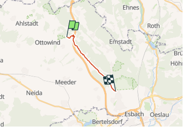
Trail On foot of 8.2 km to be discovered at Bavaria, Landkreis Coburg, Meeder. This trail is proposed by SityTrail - itinéraires balisés pédestres.

Description

Trail created by Thüringerwald-Verein Coburg.

Symbol: Roter Gegenschrägstrich auf weißem Grund


Website: http://www.farnkraut-coburg.de/html/oberlauter_-_sennigshohe.html

Elevation profile

Photos

Positioning

Country:
Germany
Region :
Bavaria
Department/Province :
Landkreis Coburg
Municipality :
Meeder
Location:
Unknown
Start:(UTM)
635845 ; 5580311 (32U) N.

Trails nearby

Trail On foot Schalkau - Dockenweg - Photo
On foot
GUIDE+

On foot

Medium
Schalkau, Thuringia, Landkreis Sonneberg, Germany
23 km | 30 km-effort
6h 43min
No
Trail On foot Eisfeld - Grünes Band Thüringen LK SON - Photo
On foot
GUIDE+

On foot

Medium
Eisfeld, Thuringia, Landkreis Hildburghausen, Germany
16.7 km | 21 km-effort
4h 46min
No


Close
My subscriptions