![](/images/other/stat-length.png)
![Trail On foot Niedenstein - Habichtswaldsteig - Extratour Niedenstein - Photo](https://media.geolcdn.com/t/1900/400/ext.pjpeg?maxdim=2&url=https%3A%2F%2Fstatic1.geolcdn.com%2Fsiteimages%2Fupload%2Ffiles%2F1545311037marcheuse_200dpi.jpg)
Habichtswaldsteig - Extratour Niedenstein
SityTrail - itinéraires balisés pédestres
Tous les sentiers balisés d’Europe GUIDE+
![Length](/images/other/stat-length.png)
![Max alt](https://static1.geolcdn.com/siteimages/upload/files/1508320355ic_sort_altitude_max_24dp.png)
![Uphill gradient](https://static1.geolcdn.com/siteimages/upload/files/1508320355ic_sort_den_pos_24dp.png)
![Km-Effort](/images/other/stat-length.png)
![Min alt](https://static1.geolcdn.com/siteimages/upload/files/1508320355ic_sort_altitude_min_24dp.png)
![Downhill gradient](https://static1.geolcdn.com/siteimages/upload/files/1508320355ic_sort_den_neg_24dp.png)
![Boucle](https://static1.geolcdn.com/siteimages/upload/files/16400158638029165_repeat_loop_refresh_sync_direction_icon.png)
![On foot](https://static1.geolcdn.com/sitytour/trail-icons/100.png)
4h56
Difficulty : Medium
![Scan this QR Code to open this trail in the SityTrail application](https://capi.geolives.com/qq0zvz2zws4bq2lad0pu/sitytour/trails/3092327/qr.png?size=200)
FREE GPS app for hiking
About
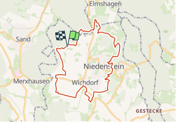
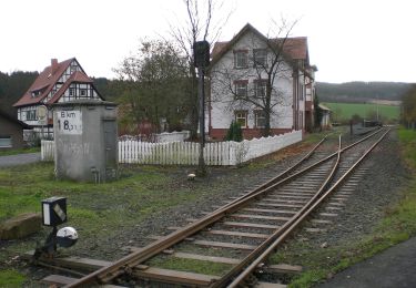
Trail On foot of 16.4 km to be discovered at Hesse, Schwalm-Eder-Kreis, Niedenstein. This trail is proposed by SityTrail - itinéraires balisés pédestres.
Description
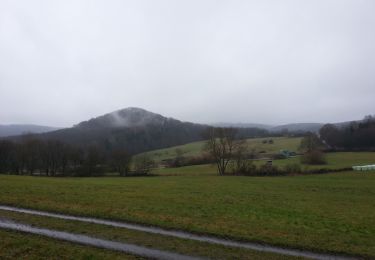
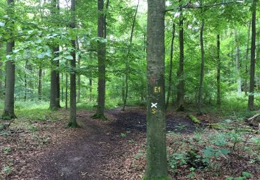
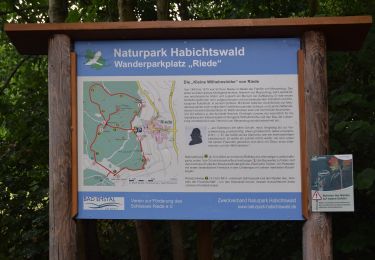
Die Extratour führt Sie am Rande des Habichtswaldes entlang, in die anschließenden Tallandschaft des Chattengaus. Zwischen Wäldern und Wiesen erhalten Sie einen Ausblick auf rund 60 km entfernte Dörfer und Wälder. Frühzeitliche Höhensiedlungen und geschichtsträchtige Böden erzählen von ihrer früheren Bevölkerung. Ein Farbspiel der Natur lässt sich hier zu jeder Jahreszeit bewundern.
Website: https://www.urlaub-habichtswald.de/touren/h5-im-bann-der-chatten
Positioning
Comments
Trails nearby
![Trail On foot Niedenstein - Niedenstein, N3 - Sengelsberg - Photo](https://media.geolcdn.com/t/375/260/4ed4a3a2-bd5e-4fad-8f78-44d080b6d336.jpeg&format=jpg&maxdim=2)
![On foot On foot](https://static1.geolcdn.com/sitytour/trail-icons/100.png)
On foot
![](/images/other/stat-length.png)
![](https://static1.geolcdn.com/siteimages/upload/files/16400158638029165_repeat_loop_refresh_sync_direction_icon.png)
![Trail On foot Bad Emstal - Rundwanderweg](https://media.geolcdn.com/t/375/260/6152dd1e-c62a-41d9-ac07-c6e6a253257c.jpeg&format=jpg&maxdim=2)
![On foot On foot](https://static1.geolcdn.com/sitytour/trail-icons/100.png)
On foot
![](/images/other/stat-length.png)
![](https://static1.geolcdn.com/siteimages/upload/files/16400158638029165_repeat_loop_refresh_sync_direction_icon.png)
![Trail On foot Bad Emstal - Naturparkweg 2 - Photo](https://media.geolcdn.com/t/375/260/56644780-7d07-49f2-8524-c7cbbaefe392.jpeg&format=jpg&maxdim=2)
![On foot On foot](https://static1.geolcdn.com/sitytour/trail-icons/100.png)
On foot
![](/images/other/stat-length.png)
![](https://static1.geolcdn.com/siteimages/upload/files/16400158638029165_repeat_loop_refresh_sync_direction_icon.png)
![Trail On foot Schauenburg - Schauenburg, S5 - Photo](https://media.geolcdn.com/t/375/260/6a77dc7f-f009-4e54-bde5-58b683fb2794.jpeg&format=jpg&maxdim=2)
![On foot On foot](https://static1.geolcdn.com/sitytour/trail-icons/100.png)
On foot
![](/images/other/stat-length.png)
![](https://static1.geolcdn.com/siteimages/upload/files/16400158638029165_repeat_loop_refresh_sync_direction_icon.png)
![Trail On foot Gudensberg - Gestecke - Niedenstein - Photo](https://media.geolcdn.com/t/375/260/a26f92b6-32e7-469f-a02f-37ebc420b105.jpeg&format=jpg&maxdim=2)
![On foot On foot](https://static1.geolcdn.com/sitytour/trail-icons/100.png)
On foot
![](/images/other/stat-length.png)
![](https://static1.geolcdn.com/siteimages/upload/files/16400158638029165_repeat_loop_refresh_sync_direction_icon.png)
![Trail On foot Schauenburg - Schauenburg-Breitenbach, Rundweg 1 - Photo](https://media.geolcdn.com/t/375/260/032608dc-851a-4041-9641-fe96126ffeaa.jpeg&format=jpg&maxdim=2)
![On foot On foot](https://static1.geolcdn.com/sitytour/trail-icons/100.png)
On foot
![](/images/other/stat-length.png)
![](https://static1.geolcdn.com/siteimages/upload/files/16400158638029165_repeat_loop_refresh_sync_direction_icon.png)
![Trail On foot Bad Emstal - Schauenburg, S1 - Photo](https://media.geolcdn.com/t/375/260/032608dc-851a-4041-9641-fe96126ffeaa.jpeg&format=jpg&maxdim=2)
![On foot On foot](https://static1.geolcdn.com/sitytour/trail-icons/100.png)
On foot
![](/images/other/stat-length.png)
![](https://static1.geolcdn.com/siteimages/upload/files/16400158638029165_repeat_loop_refresh_sync_direction_icon.png)
![Trail On foot Niedenstein - Niedenstein, N5 - Rundweg zur Ruine Falkenstein - Photo](https://media.geolcdn.com/t/375/260/4ed4a3a2-bd5e-4fad-8f78-44d080b6d336.jpeg&format=jpg&maxdim=2)
![On foot On foot](https://static1.geolcdn.com/sitytour/trail-icons/100.png)
On foot
![](/images/other/stat-length.png)
![](https://static1.geolcdn.com/siteimages/upload/files/16400158638029165_repeat_loop_refresh_sync_direction_icon.png)
![Trail On foot Bad Emstal - Naturparkweg 1 - Photo](https://media.geolcdn.com/t/375/260/56644780-7d07-49f2-8524-c7cbbaefe392.jpeg&format=jpg&maxdim=2)
![On foot On foot](https://static1.geolcdn.com/sitytour/trail-icons/100.png)
On foot
![](/images/other/stat-length.png)
![](https://static1.geolcdn.com/siteimages/upload/files/16400158638029165_repeat_loop_refresh_sync_direction_icon.png)