![](/images/other/stat-length.png)
![Trail On foot Knüllwald - Waldwunderweg - Photo](https://media.geolcdn.com/t/1900/400/4feda462-17de-40b8-8252-9952966b1e66.jpeg&format=pjpeg&maxdim=2)
Waldwunderweg
SityTrail - itinéraires balisés pédestres
Tous les sentiers balisés d’Europe GUIDE+
![Length](/images/other/stat-length.png)
Length
5.7 km
![Max alt](https://static1.geolcdn.com/siteimages/upload/files/1508320355ic_sort_altitude_max_24dp.png)
Max alt
363 m
![Uphill gradient](https://static1.geolcdn.com/siteimages/upload/files/1508320355ic_sort_den_pos_24dp.png)
Uphill gradient
143 m
![Km-Effort](/images/other/stat-length.png)
Km-Effort
7.6 km
![Min alt](https://static1.geolcdn.com/siteimages/upload/files/1508320355ic_sort_altitude_min_24dp.png)
Min alt
271 m
![Downhill gradient](https://static1.geolcdn.com/siteimages/upload/files/1508320355ic_sort_den_neg_24dp.png)
Downhill gradient
146 m
![Boucle](https://static1.geolcdn.com/siteimages/upload/files/16400158638029165_repeat_loop_refresh_sync_direction_icon.png)
Boucle
Yes
Signpost
Creation date :
2022-02-11 14:11:12.808
Updated on :
2022-02-11 14:11:12.808
![On foot](https://static1.geolcdn.com/sitytour/trail-icons/100.png)
1h43
Difficulty : Easy
![Scan this QR Code to open this trail in the SityTrail application](https://capi.geolives.com/qq0zvz2zws4bq2lad0pu/sitytour/trails/3092176/qr.png?size=200)
FREE GPS app for hiking
About
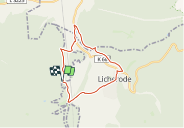
Trail On foot of 5.7 km to be discovered at Hesse, Schwalm-Eder-Kreis, Knüllwald. This trail is proposed by SityTrail - itinéraires balisés pédestres.
Description
Symbol: gelber Text L3 auf grünem Grund
Website: https://www.alheim.de/verzeichnis/objekt.php?mandat=32238
Positioning
Country:
Germany
Region :
Hesse
Department/Province :
Schwalm-Eder-Kreis
Municipality :
Knüllwald
Location:
Unknown
Start:(Dec)
Start:(UTM)
540232 ; 5651864 (32U) N.
Comments
Trails nearby
![Trail On foot Morschen - Niederellenbach Rundweg N3 - Photo](https://media.geolcdn.com/t/375/260/27f940e0-908d-449a-a03f-331b419b788d.jpeg&format=jpg&maxdim=2)
![On foot On foot](https://static1.geolcdn.com/sitytour/trail-icons/100.png)
Niederellenbach Rundweg N3
On foot
Easy
Morschen,
Hesse,
Schwalm-Eder-Kreis,
Germany
![](/images/other/stat-length.png)
8.5 km | 10.1 km-effort
2h 18min
![](https://static1.geolcdn.com/siteimages/upload/files/16400158638029165_repeat_loop_refresh_sync_direction_icon.png)
Yes
![Trail On foot Morschen - Licherode Rundweg L4 - Photo](https://media.geolcdn.com/t/375/260/8551ba29-fcce-47ca-b32e-bfaa3141ad3f.jpeg&format=jpg&maxdim=2)
![On foot On foot](https://static1.geolcdn.com/sitytour/trail-icons/100.png)
Licherode Rundweg L4
On foot
Easy
Morschen,
Hesse,
Schwalm-Eder-Kreis,
Germany
![](/images/other/stat-length.png)
7.3 km | 10.5 km-effort
2h 22min
![](https://static1.geolcdn.com/siteimages/upload/files/16400158638029165_repeat_loop_refresh_sync_direction_icon.png)
Yes
![Trail On foot Morschen - Morschen Rundweg M3 - Photo](https://media.geolcdn.com/t/375/260/e6bdf1bc-3969-498a-add2-4d9b9d27924d.jpeg&format=jpg&maxdim=2)
![On foot On foot](https://static1.geolcdn.com/sitytour/trail-icons/100.png)
Morschen Rundweg M3
On foot
Easy
Morschen,
Hesse,
Schwalm-Eder-Kreis,
Germany
![](/images/other/stat-length.png)
12.3 km | 17.3 km-effort
3h 55min
![](https://static1.geolcdn.com/siteimages/upload/files/16400158638029165_repeat_loop_refresh_sync_direction_icon.png)
Yes
![Trail On foot Alheim - Sterkelshausen Rundweg S4 - Photo](https://media.geolcdn.com/t/375/260/ext.jpg?maxdim=2&url=https%3A%2F%2Fstatic1.geolcdn.com%2Fsiteimages%2Fupload%2Ffiles%2F1545311037marcheuse_200dpi.jpg)
![On foot On foot](https://static1.geolcdn.com/sitytour/trail-icons/100.png)
Sterkelshausen Rundweg S4
On foot
Easy
Alheim,
Hesse,
Landkreis Hersfeld-Rotenburg,
Germany
![](/images/other/stat-length.png)
8.7 km | 11.9 km-effort
2h 42min
![](https://static1.geolcdn.com/siteimages/upload/files/16400158638029165_repeat_loop_refresh_sync_direction_icon.png)
Yes
![Trail On foot Alheim - Sterkelshausen Rundweg S2 - Photo](https://media.geolcdn.com/t/375/260/ext.jpg?maxdim=2&url=https%3A%2F%2Fstatic1.geolcdn.com%2Fsiteimages%2Fupload%2Ffiles%2F1545311037marcheuse_200dpi.jpg)
![On foot On foot](https://static1.geolcdn.com/sitytour/trail-icons/100.png)
Sterkelshausen Rundweg S2
On foot
Easy
Alheim,
Hesse,
Landkreis Hersfeld-Rotenburg,
Germany
![](/images/other/stat-length.png)
8 km | 11 km-effort
2h 29min
![](https://static1.geolcdn.com/siteimages/upload/files/16400158638029165_repeat_loop_refresh_sync_direction_icon.png)
Yes
![Trail On foot Alheim - Oberellenbacher Rundwanderweg O1 - Photo](https://media.geolcdn.com/t/375/260/ext.jpg?maxdim=2&url=https%3A%2F%2Fstatic1.geolcdn.com%2Fsiteimages%2Fupload%2Ffiles%2F1545311037marcheuse_200dpi.jpg)
![On foot On foot](https://static1.geolcdn.com/sitytour/trail-icons/100.png)
Oberellenbacher Rundwanderweg O1
On foot
Easy
Alheim,
Hesse,
Landkreis Hersfeld-Rotenburg,
Germany
![](/images/other/stat-length.png)
4.9 km | 6.7 km-effort
1h 30min
![](https://static1.geolcdn.com/siteimages/upload/files/16400158638029165_repeat_loop_refresh_sync_direction_icon.png)
Yes
![Trail On foot Alheim - Oberellenbacher Rundwanderweg O3 - Photo](https://media.geolcdn.com/t/375/260/ext.jpg?maxdim=2&url=https%3A%2F%2Fstatic1.geolcdn.com%2Fsiteimages%2Fupload%2Ffiles%2F1545311037marcheuse_200dpi.jpg)
![On foot On foot](https://static1.geolcdn.com/sitytour/trail-icons/100.png)
Oberellenbacher Rundwanderweg O3
On foot
Easy
Alheim,
Hesse,
Landkreis Hersfeld-Rotenburg,
Germany
![](/images/other/stat-length.png)
5.2 km | 6.9 km-effort
1h 34min
![](https://static1.geolcdn.com/siteimages/upload/files/16400158638029165_repeat_loop_refresh_sync_direction_icon.png)
Yes
![Trail On foot Alheim - Oberellenbacher Rundwanderweg O6 - Photo](https://media.geolcdn.com/t/375/260/ext.jpg?maxdim=2&url=https%3A%2F%2Fstatic1.geolcdn.com%2Fsiteimages%2Fupload%2Ffiles%2F1545311037marcheuse_200dpi.jpg)
![On foot On foot](https://static1.geolcdn.com/sitytour/trail-icons/100.png)
Oberellenbacher Rundwanderweg O6
On foot
Easy
Alheim,
Hesse,
Landkreis Hersfeld-Rotenburg,
Germany
![](/images/other/stat-length.png)
5.7 km | 7.4 km-effort
1h 40min
![](https://static1.geolcdn.com/siteimages/upload/files/16400158638029165_repeat_loop_refresh_sync_direction_icon.png)
Yes
![Trail On foot Alheim - Licherode Rundweg L2 - Photo](https://media.geolcdn.com/t/375/260/ext.jpg?maxdim=2&url=https%3A%2F%2Fstatic1.geolcdn.com%2Fsiteimages%2Fupload%2Ffiles%2F1545311037marcheuse_200dpi.jpg)
![On foot On foot](https://static1.geolcdn.com/sitytour/trail-icons/100.png)
Licherode Rundweg L2
On foot
Easy
Alheim,
Hesse,
Landkreis Hersfeld-Rotenburg,
Germany
![](/images/other/stat-length.png)
7.4 km | 10.6 km-effort
2h 24min
![](https://static1.geolcdn.com/siteimages/upload/files/16400158638029165_repeat_loop_refresh_sync_direction_icon.png)
Yes