Trail On foot Kierspe - Raukweg - Photo

Tous les sentiers balisés d’Europe GUIDE+

© OpenStreetMap contributors
Length
Length
24 km
Max alt
Max alt
488 m
Uphill gradient
Uphill gradient
608 m
Km-Effort
Km-Effort  
32 km
Min alt
Min alt
342 m
Downhill gradient
Downhill gradient
605 m
Boucle
Boucle
Yes
Signpost
Signpost
Creation date :
2022-02-11 14:04:21.783
Updated on :
2022-02-11 14:04:21.783

(0 Reviews)

On foot
On foot
7h23
Difficulty : Difficult

Scan this QR Code to open this trail in the SityTrail application

FREE GPS app for hiking

Logo SityTrail SityTrail

IGN / Geographical institutes

Download SityTrail from the App Store Download SityTrail from Google Play

Logo SityTrail SityTrail World

The world is yours!

Download SityTrail from the App Store Download SityTrail from Google Play Download SityTrail on Huawei AppGallery

About

Trail On foot of 24 km to be discovered at North Rhine-Westphalia, Märkischer Kreis, Kierspe. This trail is proposed by SityTrail - itinéraires balisés pédestres.

Description

Trail created by Stad Kierspe.

Symbol: white field with black bird, its beak gives direction

Elevation profile

Photos

Positioning

Country:
Germany
Region :
North Rhine-Westphalia
Department/Province :
Märkischer Kreis
Municipality :
Kierspe
Location:
Unknown
Start:(UTM)
400065 ; 5666547 (32U) N.

Trails nearby

Trail On foot Marienheide - Rundweg A9 (Schmitzwipper) - Photo
On foot
GUIDE+

On foot

Easy
Marienheide, North Rhine-Westphalia, Oberbergischer Kreis, Germany
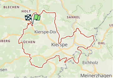
6.4 km | 8.7 km-effort
1h 58min
Yes


Close
My subscriptions