![](/images/other/stat-length.png)
![Trail On foot Iffeldorf - Osterseen-Wanderweg 25 - Photo](https://media.geolcdn.com/t/1900/400/ext.pjpeg?maxdim=2&url=https%3A%2F%2Fmedia.geolcdn.com%2Ff%2Fe69998aa-7541-40f3-bffd-b5dc9d2d38f1.jpeg)
Osterseen-Wanderweg 25
SityTrail - itinéraires balisés pédestres
Tous les sentiers balisés d’Europe PRO
![Length](/images/other/stat-length.png)
Length
7.7 km
![Max alt](https://static1.geolcdn.com/siteimages/upload/files/1508320355ic_sort_altitude_max_24dp.png)
Max alt
613 m
![Uphill gradient](https://static1.geolcdn.com/siteimages/upload/files/1508320355ic_sort_den_pos_24dp.png)
Uphill gradient
112 m
![Km-Effort](/images/other/stat-length.png)
Km-Effort
9.2 km
![Min alt](https://static1.geolcdn.com/siteimages/upload/files/1508320355ic_sort_altitude_min_24dp.png)
Min alt
588 m
![Downhill gradient](https://static1.geolcdn.com/siteimages/upload/files/1508320355ic_sort_den_neg_24dp.png)
Downhill gradient
109 m
![Boucle](https://static1.geolcdn.com/siteimages/upload/files/16400158638029165_repeat_loop_refresh_sync_direction_icon.png)
Boucle
Yes
Signpost
Creation date :
2022-02-11 14:02:14.846
Updated on :
2022-02-11 14:02:14.846
![On foot](https://static1.geolcdn.com/sitytour/trail-icons/100.png)
2h05
Difficulty : Easy
![Scan this QR Code to open this trail in the SityTrail application](https://capi.geolives.com/qq0zvz2zws4bq2lad0pu/sitytour/trails/3091810/qr.png?size=200)
FREE GPS app for hiking
About
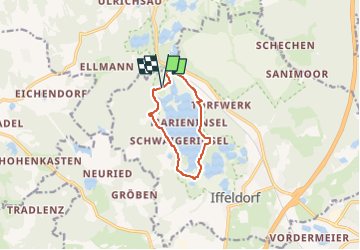
Trail On foot of 7.7 km to be discovered at Bavaria, Landkreis Weilheim-Schongau, Iffeldorf. This trail is proposed by SityTrail - itinéraires balisés pédestres.
Description
http://hiking.waymarkedtrails.org former number 7, osmc:symbol=yellow:white:yellow_dot:7:black
Positioning
Country:
Germany
Region :
Bavaria
Department/Province :
Landkreis Weilheim-Schongau
Municipality :
Iffeldorf
Location:
Unknown
Start:(Dec)
Start:(UTM)
671854 ; 5296412 (32T) N.
Comments
Trails nearby
![Trail On foot Iffeldorf - Kleiner Lauterbacher Waldweg 22 - Photo](https://media.geolcdn.com/t/375/260/ext.jpg?maxdim=2&url=https%3A%2F%2Fmedia.geolcdn.com%2Ff%2F0915bea0-1f0a-41f6-bc56-1497b5dc043a.jpeg)
![On foot On foot](https://static1.geolcdn.com/sitytour/trail-icons/100.png)
Kleiner Lauterbacher Waldweg 22
On foot
Easy
Iffeldorf,
Bavaria,
Landkreis Weilheim-Schongau,
Germany
![](/images/other/stat-length.png)
13.6 km | 16.9 km-effort
3h 49min
![](https://static1.geolcdn.com/siteimages/upload/files/16400158638029165_repeat_loop_refresh_sync_direction_icon.png)
Yes
![Trail On foot Iffeldorf - Großer Lauterbacher Waldweg 21 - Photo](https://media.geolcdn.com/t/375/260/ext.jpg?maxdim=2&url=https%3A%2F%2Fmedia.geolcdn.com%2Ff%2F0915bea0-1f0a-41f6-bc56-1497b5dc043a.jpeg)
![On foot On foot](https://static1.geolcdn.com/sitytour/trail-icons/100.png)
Großer Lauterbacher Waldweg 21
On foot
Medium
Iffeldorf,
Bavaria,
Landkreis Weilheim-Schongau,
Germany
![](/images/other/stat-length.png)
17.3 km | 21 km-effort
4h 47min
![](https://static1.geolcdn.com/siteimages/upload/files/16400158638029165_repeat_loop_refresh_sync_direction_icon.png)
Yes
![Trail On foot Iffeldorf - Osterseen-Wanderweg 6 - Photo](https://media.geolcdn.com/t/375/260/ext.jpg?maxdim=2&url=https%3A%2F%2Fmedia.geolcdn.com%2Ff%2F3781b768-290b-4906-900a-7c7defb71d50.jpeg)
![On foot On foot](https://static1.geolcdn.com/sitytour/trail-icons/100.png)
Osterseen-Wanderweg 6
On foot
Easy
Iffeldorf,
Bavaria,
Landkreis Weilheim-Schongau,
Germany
![](/images/other/stat-length.png)
4.1 km | 4.8 km-effort
1h 5min
![](https://static1.geolcdn.com/siteimages/upload/files/16400158638029165_repeat_loop_refresh_sync_direction_icon.png)
Yes
![Trail On foot Iffeldorf - Osterseen-Wanderweg 5 - Photo](https://media.geolcdn.com/t/375/260/ext.jpg?maxdim=2&url=https%3A%2F%2Fmedia.geolcdn.com%2Ff%2Fb70ae96d-b01f-4237-84de-74fc7b6b526c.jpeg)
![On foot On foot](https://static1.geolcdn.com/sitytour/trail-icons/100.png)
Osterseen-Wanderweg 5
On foot
Easy
Iffeldorf,
Bavaria,
Landkreis Weilheim-Schongau,
Germany
![](/images/other/stat-length.png)
4.4 km | 5.3 km-effort
1h 11min
![](https://static1.geolcdn.com/siteimages/upload/files/16400158638029165_repeat_loop_refresh_sync_direction_icon.png)
Yes
![Trail On foot Seeshaupt - Osterseen-Wanderweg 10 - Photo](https://media.geolcdn.com/t/375/260/ext.jpg?maxdim=2&url=https%3A%2F%2Fmedia.geolcdn.com%2Ff%2F0915bea0-1f0a-41f6-bc56-1497b5dc043a.jpeg)
![On foot On foot](https://static1.geolcdn.com/sitytour/trail-icons/100.png)
Osterseen-Wanderweg 10
On foot
Easy
Seeshaupt,
Bavaria,
Landkreis Weilheim-Schongau,
Germany
![](/images/other/stat-length.png)
9.7 km | 11.2 km-effort
2h 32min
![](https://static1.geolcdn.com/siteimages/upload/files/16400158638029165_repeat_loop_refresh_sync_direction_icon.png)
Yes
![Trail On foot Iffeldorf - Osterseen-Wanderweg 8 - Photo](https://media.geolcdn.com/t/375/260/ext.jpg?maxdim=2&url=https%3A%2F%2Fmedia.geolcdn.com%2Ff%2Fc62e2ceb-9609-4e74-9a3a-2132ca727114.jpeg)
![On foot On foot](https://static1.geolcdn.com/sitytour/trail-icons/100.png)
Osterseen-Wanderweg 8
On foot
Easy
Iffeldorf,
Bavaria,
Landkreis Weilheim-Schongau,
Germany
![](/images/other/stat-length.png)
4 km | 4.8 km-effort
1h 5min
![](https://static1.geolcdn.com/siteimages/upload/files/16400158638029165_repeat_loop_refresh_sync_direction_icon.png)
Yes
![Trail On foot Seeshaupt - Osterseen-Wanderweg 9 - Photo](https://media.geolcdn.com/t/375/260/ext.jpg?maxdim=2&url=https%3A%2F%2Fmedia.geolcdn.com%2Ff%2F3c04869c-fcf9-4b0e-8ed2-e3686c086a69.jpeg)
![On foot On foot](https://static1.geolcdn.com/sitytour/trail-icons/100.png)
Osterseen-Wanderweg 9
On foot
Easy
Seeshaupt,
Bavaria,
Landkreis Weilheim-Schongau,
Germany
![](/images/other/stat-length.png)
3.7 km | 4.5 km-effort
1h 0min
![](https://static1.geolcdn.com/siteimages/upload/files/16400158638029165_repeat_loop_refresh_sync_direction_icon.png)
No