![](/images/other/stat-length.png)
![Trail On foot Nümbrecht - Golddörfer-Route - Rundweg Schlossblicke - Photo](https://media.geolcdn.com/t/1900/400/5f57f097-b7e5-4b91-8722-e83718571a74.jpeg&format=pjpeg&maxdim=2)
Golddörfer-Route - Rundweg Schlossblicke
SityTrail - itinéraires balisés pédestres
Tous les sentiers balisés d’Europe GUIDE+
![Length](/images/other/stat-length.png)
Length
15.5 km
![Max alt](https://static1.geolcdn.com/siteimages/upload/files/1508320355ic_sort_altitude_max_24dp.png)
Max alt
309 m
![Uphill gradient](https://static1.geolcdn.com/siteimages/upload/files/1508320355ic_sort_den_pos_24dp.png)
Uphill gradient
373 m
![Km-Effort](/images/other/stat-length.png)
Km-Effort
21 km
![Min alt](https://static1.geolcdn.com/siteimages/upload/files/1508320355ic_sort_altitude_min_24dp.png)
Min alt
190 m
![Downhill gradient](https://static1.geolcdn.com/siteimages/upload/files/1508320355ic_sort_den_neg_24dp.png)
Downhill gradient
375 m
![Boucle](https://static1.geolcdn.com/siteimages/upload/files/16400158638029165_repeat_loop_refresh_sync_direction_icon.png)
Boucle
Yes
Signpost
Creation date :
2022-02-11 14:01:08.994
Updated on :
2022-02-11 14:01:08.994
![On foot](https://static1.geolcdn.com/sitytour/trail-icons/100.png)
4h39
Difficulty : Medium
![Scan this QR Code to open this trail in the SityTrail application](https://capi.geolives.com/qq0zvz2zws4bq2lad0pu/sitytour/trails/3091774/qr.png?size=200)
FREE GPS app for hiking
About
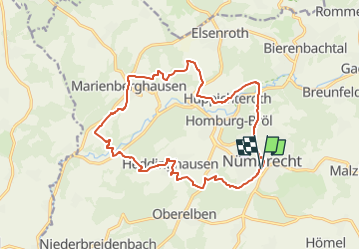
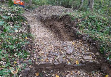
Trail On foot of 15.5 km to be discovered at North Rhine-Westphalia, Oberbergischer Kreis, Nümbrecht. This trail is proposed by SityTrail - itinéraires balisés pédestres.
Description
Website: https://cdn.nuembrecht.de/fileadmin/user_upload/dokumente/Wanderwege_PDFs/Goldroute.pdf
Positioning
Country:
Germany
Region :
North Rhine-Westphalia
Department/Province :
Oberbergischer Kreis
Municipality :
Nümbrecht
Location:
Unknown
Start:(Dec)
Start:(UTM)
397375 ; 5639895 (32U) N.
Comments
Trails nearby
![Trail On foot Nümbrecht - Nümbrecht Kurpark Rundweg A1 - Photo](https://media.geolcdn.com/t/375/260/5f57f097-b7e5-4b91-8722-e83718571a74.jpeg&format=jpg&maxdim=2)
![On foot On foot](https://static1.geolcdn.com/sitytour/trail-icons/100.png)
Nümbrecht Kurpark Rundweg A1
On foot
Easy
Nümbrecht,
North Rhine-Westphalia,
Oberbergischer Kreis,
Germany
![](/images/other/stat-length.png)
5 km | 6.1 km-effort
1h 23min
![](https://static1.geolcdn.com/siteimages/upload/files/16400158638029165_repeat_loop_refresh_sync_direction_icon.png)
No
![Trail On foot Nümbrecht - Rundweg Schlossblicke Turmroute - Photo](https://media.geolcdn.com/t/375/260/7d9fb8f1-1fb6-4ef0-8ecc-b5b938933784.jpeg&format=jpg&maxdim=2)
![On foot On foot](https://static1.geolcdn.com/sitytour/trail-icons/100.png)
Rundweg Schlossblicke Turmroute
On foot
Easy
Nümbrecht,
North Rhine-Westphalia,
Oberbergischer Kreis,
Germany
![](/images/other/stat-length.png)
14.2 km | 18.3 km-effort
4h 9min
![](https://static1.geolcdn.com/siteimages/upload/files/16400158638029165_repeat_loop_refresh_sync_direction_icon.png)
Yes
![Trail On foot Nümbrecht - Harscheid Rundweg A2 - Photo](https://media.geolcdn.com/t/375/260/0001159d-fd4c-4293-8cb6-a0ffd7657e45.jpeg&format=jpg&maxdim=2)
![On foot On foot](https://static1.geolcdn.com/sitytour/trail-icons/100.png)
Harscheid Rundweg A2
On foot
Easy
Nümbrecht,
North Rhine-Westphalia,
Oberbergischer Kreis,
Germany
![](/images/other/stat-length.png)
5.5 km | 7.3 km-effort
1h 40min
![](https://static1.geolcdn.com/siteimages/upload/files/16400158638029165_repeat_loop_refresh_sync_direction_icon.png)
Yes
![Trail On foot Wiehl - Tropfsteinhöhle Rundweg A3 - Photo](https://media.geolcdn.com/t/375/260/1973a416-ed7d-4506-ba2f-bad32821f5b1.jpeg&format=jpg&maxdim=2)
![On foot On foot](https://static1.geolcdn.com/sitytour/trail-icons/100.png)
Tropfsteinhöhle Rundweg A3
On foot
Easy
Wiehl,
North Rhine-Westphalia,
Oberbergischer Kreis,
Germany
![](/images/other/stat-length.png)
4.3 km | 5.5 km-effort
1h 15min
![](https://static1.geolcdn.com/siteimages/upload/files/16400158638029165_repeat_loop_refresh_sync_direction_icon.png)
Yes
![Trail On foot Nümbrecht - Rundweg Schloß Homburg/Nümbrecht Kurpark - Photo](https://media.geolcdn.com/t/375/260/5f57f097-b7e5-4b91-8722-e83718571a74.jpeg&format=jpg&maxdim=2)
![On foot On foot](https://static1.geolcdn.com/sitytour/trail-icons/100.png)
Rundweg Schloß Homburg/Nümbrecht Kurpark
On foot
Easy
Nümbrecht,
North Rhine-Westphalia,
Oberbergischer Kreis,
Germany
![](/images/other/stat-length.png)
3.4 km | 4.4 km-effort
59min
![](https://static1.geolcdn.com/siteimages/upload/files/16400158638029165_repeat_loop_refresh_sync_direction_icon.png)
No
![Trail On foot Nümbrecht - Rechteck Nümbrecht-Homburg-Marienberghausen - Photo](https://media.geolcdn.com/t/375/260/8aa77e14-2b77-46aa-a7f2-54fea8730045.jpeg&format=jpg&maxdim=2)
![On foot On foot](https://static1.geolcdn.com/sitytour/trail-icons/100.png)
Rechteck Nümbrecht-Homburg-Marienberghausen
On foot
Easy
Nümbrecht,
North Rhine-Westphalia,
Oberbergischer Kreis,
Germany
![](/images/other/stat-length.png)
7.1 km | 9.3 km-effort
2h 6min
![](https://static1.geolcdn.com/siteimages/upload/files/16400158638029165_repeat_loop_refresh_sync_direction_icon.png)
No
![Trail On foot Nümbrecht - Nümbrecht Rundweg A3 - Photo](https://media.geolcdn.com/t/375/260/5f57f097-b7e5-4b91-8722-e83718571a74.jpeg&format=jpg&maxdim=2)
![On foot On foot](https://static1.geolcdn.com/sitytour/trail-icons/100.png)
Nümbrecht Rundweg A3
On foot
Easy
Nümbrecht,
North Rhine-Westphalia,
Oberbergischer Kreis,
Germany
![](/images/other/stat-length.png)
3.4 km | 4.4 km-effort
59min
![](https://static1.geolcdn.com/siteimages/upload/files/16400158638029165_repeat_loop_refresh_sync_direction_icon.png)
No
![Trail On foot Wiehl - Tropfsteinhöhle Rundweg A2 - Photo](https://media.geolcdn.com/t/375/260/ext.jpg?maxdim=2&url=https%3A%2F%2Fstatic1.geolcdn.com%2Fsiteimages%2Fupload%2Ffiles%2F1545311037marcheuse_200dpi.jpg)
![On foot On foot](https://static1.geolcdn.com/sitytour/trail-icons/100.png)
Tropfsteinhöhle Rundweg A2
On foot
Easy
Wiehl,
North Rhine-Westphalia,
Oberbergischer Kreis,
Germany
![](/images/other/stat-length.png)
3.6 km | 4.8 km-effort
1h 5min
![](https://static1.geolcdn.com/siteimages/upload/files/16400158638029165_repeat_loop_refresh_sync_direction_icon.png)
No