![](/images/other/stat-length.png)
![Trail On foot Schwandorf - Rundweg 3](https://media.geolcdn.com/t/1900/400/ext.pjpeg?maxdim=2&url=https%3A%2F%2Fstatic1.geolcdn.com%2Fsiteimages%2Fupload%2Ffiles%2F1545311037marcheuse_200dpi.jpg)
Rundweg 3 "Hans Graf Weg"
SityTrail - itinéraires balisés pédestres
Tous les sentiers balisés d’Europe GUIDE+
![Length](/images/other/stat-length.png)
Length
10.8 km
![Max alt](https://static1.geolcdn.com/siteimages/upload/files/1508320355ic_sort_altitude_max_24dp.png)
Max alt
522 m
![Uphill gradient](https://static1.geolcdn.com/siteimages/upload/files/1508320355ic_sort_den_pos_24dp.png)
Uphill gradient
189 m
![Km-Effort](/images/other/stat-length.png)
Km-Effort
13.3 km
![Min alt](https://static1.geolcdn.com/siteimages/upload/files/1508320355ic_sort_altitude_min_24dp.png)
Min alt
384 m
![Downhill gradient](https://static1.geolcdn.com/siteimages/upload/files/1508320355ic_sort_den_neg_24dp.png)
Downhill gradient
185 m
![Boucle](https://static1.geolcdn.com/siteimages/upload/files/16400158638029165_repeat_loop_refresh_sync_direction_icon.png)
Boucle
Yes
Signpost
Creation date :
2022-02-11 13:42:19.232
Updated on :
2022-02-11 13:42:19.232
![On foot](https://static1.geolcdn.com/sitytour/trail-icons/100.png)
3h02
Difficulty : Easy
![Scan this QR Code to open this trail in the SityTrail application](https://capi.geolives.com/qq0zvz2zws4bq2lad0pu/sitytour/trails/3090958/qr.png?size=200)
FREE GPS app for hiking
About
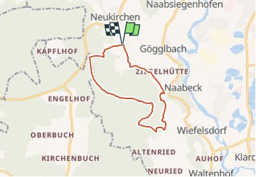
Trail On foot of 10.8 km to be discovered at Bavaria, Landkreis Schwandorf, Schwandorf. This trail is proposed by SityTrail - itinéraires balisés pédestres.
Description
Trail created by Oberpfälzer Waldverein.
richtiges Wanderzeichen im Gelände - auf Karte leider nicht darstellbar
Website: http://www.owv-sad.de/index.php?section=ztyp1&id=55&mid=6
Positioning
Country:
Germany
Region :
Bavaria
Department/Province :
Landkreis Schwandorf
Municipality :
Schwandorf
Location:
Unknown
Start:(Dec)
Start:(UTM)
284741 ; 5465756 (33U) N.
Comments
Trails nearby
![Trail On foot Schwandorf - Rundweg 2 - Photo](https://media.geolcdn.com/t/375/260/e97b4e6c-8896-472d-b925-8291af024e3c.jpeg&format=jpg&maxdim=2)
![On foot On foot](https://static1.geolcdn.com/sitytour/trail-icons/100.png)
Rundweg 2
On foot
Easy
Schwandorf,
Bavaria,
Landkreis Schwandorf,
Germany
![](/images/other/stat-length.png)
5.6 km | 7.1 km-effort
1h 37min
![](https://static1.geolcdn.com/siteimages/upload/files/16400158638029165_repeat_loop_refresh_sync_direction_icon.png)
No
![Trail On foot Schwandorf - Wanderweg Rundweg 1](https://media.geolcdn.com/t/375/260/dddb3b8b-d7f0-48d0-aae4-b286912c1038.jpeg&format=jpg&maxdim=2)
![On foot On foot](https://static1.geolcdn.com/sitytour/trail-icons/100.png)
Wanderweg Rundweg 1 "Sieben Brücken Weg"
On foot
Easy
Schwandorf,
Bavaria,
Landkreis Schwandorf,
Germany
![](/images/other/stat-length.png)
6 km | 6.6 km-effort
1h 29min
![](https://static1.geolcdn.com/siteimages/upload/files/16400158638029165_repeat_loop_refresh_sync_direction_icon.png)
Yes