![](/images/other/stat-length.png)
![Trail On foot Neuhaus am Rennweg - 6-Kuppen-Steig - Photo](https://media.geolcdn.com/t/1900/400/1a3ff12d-4f04-4d43-b91b-61995b451ea1.jpeg&format=pjpeg&maxdim=2)
6-Kuppen-Steig
SityTrail - itinéraires balisés pédestres
Tous les sentiers balisés d’Europe GUIDE+
![Length](/images/other/stat-length.png)
Length
38 km
![Max alt](https://static1.geolcdn.com/siteimages/upload/files/1508320355ic_sort_altitude_max_24dp.png)
Max alt
854 m
![Uphill gradient](https://static1.geolcdn.com/siteimages/upload/files/1508320355ic_sort_den_pos_24dp.png)
Uphill gradient
849 m
![Km-Effort](/images/other/stat-length.png)
Km-Effort
49 km
![Min alt](https://static1.geolcdn.com/siteimages/upload/files/1508320355ic_sort_altitude_min_24dp.png)
Min alt
496 m
![Downhill gradient](https://static1.geolcdn.com/siteimages/upload/files/1508320355ic_sort_den_neg_24dp.png)
Downhill gradient
849 m
![Boucle](https://static1.geolcdn.com/siteimages/upload/files/16400158638029165_repeat_loop_refresh_sync_direction_icon.png)
Boucle
Yes
Signpost
Creation date :
2022-02-11 13:40:59.595
Updated on :
2022-02-11 13:40:59.595
![On foot](https://static1.geolcdn.com/sitytour/trail-icons/100.png)
11h06
Difficulty : Very difficult
![Scan this QR Code to open this trail in the SityTrail application](https://capi.geolives.com/qq0zvz2zws4bq2lad0pu/sitytour/trails/3090887/qr.png?size=200)
FREE GPS app for hiking
About
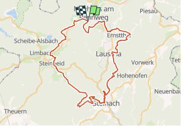
Trail On foot of 38 km to be discovered at Thuringia, Landkreis Sonneberg, Neuhaus am Rennweg. This trail is proposed by SityTrail - itinéraires balisés pédestres.
Description
Trail created by Kommunale Arbeitsgemeinschaft Neuhaus, Lauscha, Steinach und Steinheid.
Symbol: gruenes K6 auf weißer Raute
Positioning
Country:
Germany
Region :
Thuringia
Department/Province :
Landkreis Sonneberg
Municipality :
Neuhaus am Rennweg
Location:
Unknown
Start:(Dec)
Start:(UTM)
651257 ; 5596719 (32U) N.
Comments
Trails nearby
![Trail On foot Neuhaus am Rennweg - Totenweg - Photo](https://media.geolcdn.com/t/375/260/fe318406-73e9-47b4-9234-74565198b153.jpeg&format=jpg&maxdim=2)
![On foot On foot](https://static1.geolcdn.com/sitytour/trail-icons/100.png)
Totenweg
On foot
Easy
Neuhaus am Rennweg,
Thuringia,
Landkreis Sonneberg,
Germany
![](/images/other/stat-length.png)
5.6 km | 8.1 km-effort
1h 50min
![](https://static1.geolcdn.com/siteimages/upload/files/16400158638029165_repeat_loop_refresh_sync_direction_icon.png)
No
![Trail On foot Neuhaus am Rennweg - Rennsteiglauf/Marathon - Photo](https://media.geolcdn.com/t/375/260/ext.jpg?maxdim=2&url=https%3A%2F%2Fstatic1.geolcdn.com%2Fsiteimages%2Fupload%2Ffiles%2F1545311037marcheuse_200dpi.jpg)
![On foot On foot](https://static1.geolcdn.com/sitytour/trail-icons/100.png)
Rennsteiglauf/Marathon
On foot
Difficult
Neuhaus am Rennweg,
Thuringia,
Landkreis Sonneberg,
Germany
![](/images/other/stat-length.png)
26 km | 32 km-effort
7h 22min
![](https://static1.geolcdn.com/siteimages/upload/files/16400158638029165_repeat_loop_refresh_sync_direction_icon.png)
No
![Trail On foot Neuhaus am Rennweg - Sagen-& Märchenpfad - Photo](https://media.geolcdn.com/t/375/260/ext.jpg?maxdim=2&url=https%3A%2F%2Fstatic1.geolcdn.com%2Fsiteimages%2Fupload%2Ffiles%2F1545311037marcheuse_200dpi.jpg)
![On foot On foot](https://static1.geolcdn.com/sitytour/trail-icons/100.png)
Sagen-& Märchenpfad
On foot
Easy
Neuhaus am Rennweg,
Thuringia,
Landkreis Sonneberg,
Germany
![](/images/other/stat-length.png)
9.6 km | 13.1 km-effort
2h 59min
![](https://static1.geolcdn.com/siteimages/upload/files/16400158638029165_repeat_loop_refresh_sync_direction_icon.png)
Yes
![Trail On foot Neuhaus am Rennweg - Wissens- und Spielewanderweg - Photo](https://media.geolcdn.com/t/375/260/ext.jpg?maxdim=2&url=https%3A%2F%2Fstatic1.geolcdn.com%2Fsiteimages%2Fupload%2Ffiles%2F1545311037marcheuse_200dpi.jpg)
![On foot On foot](https://static1.geolcdn.com/sitytour/trail-icons/100.png)
Wissens- und Spielewanderweg
On foot
Easy
Neuhaus am Rennweg,
Thuringia,
Landkreis Sonneberg,
Germany
![](/images/other/stat-length.png)
4.9 km | 6.3 km-effort
1h 25min
![](https://static1.geolcdn.com/siteimages/upload/files/16400158638029165_repeat_loop_refresh_sync_direction_icon.png)
Yes