![](/images/other/stat-length.png)
![Trail On foot Unknown - Mülheimer Bodenschätze - Photo](https://media.geolcdn.com/t/1900/400/c36f827a-ecdc-4ce8-870a-8a48e2636599.jpeg&format=pjpeg&maxdim=2)
Mülheimer Bodenschätze
SityTrail - itinéraires balisés pédestres
Tous les sentiers balisés d’Europe GUIDE+
![Length](/images/other/stat-length.png)
Length
16 km
![Max alt](https://static1.geolcdn.com/siteimages/upload/files/1508320355ic_sort_altitude_max_24dp.png)
Max alt
98 m
![Uphill gradient](https://static1.geolcdn.com/siteimages/upload/files/1508320355ic_sort_den_pos_24dp.png)
Uphill gradient
172 m
![Km-Effort](/images/other/stat-length.png)
Km-Effort
18.3 km
![Min alt](https://static1.geolcdn.com/siteimages/upload/files/1508320355ic_sort_altitude_min_24dp.png)
Min alt
33 m
![Downhill gradient](https://static1.geolcdn.com/siteimages/upload/files/1508320355ic_sort_den_neg_24dp.png)
Downhill gradient
172 m
![Boucle](https://static1.geolcdn.com/siteimages/upload/files/16400158638029165_repeat_loop_refresh_sync_direction_icon.png)
Boucle
Yes
Signpost
Creation date :
2022-02-11 13:40:33.127
Updated on :
2022-02-11 13:40:33.127
![On foot](https://static1.geolcdn.com/sitytour/trail-icons/100.png)
4h10
Difficulty : Easy
![Scan this QR Code to open this trail in the SityTrail application](https://capi.geolives.com/qq0zvz2zws4bq2lad0pu/sitytour/trails/3090864/qr.png?size=200)
FREE GPS app for hiking
About
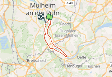
Trail On foot of 16 km to be discovered at North Rhine-Westphalia, Mülheim an der Ruhr, Unknown. This trail is proposed by SityTrail - itinéraires balisés pédestres.
Description
Trail created by Biologische Station Westliches Ruhrgebiet.
Website: https://www.muelheim-ruhr.de/cms/bodenroute_berg_und_tal.html
Positioning
Country:
Germany
Region :
North Rhine-Westphalia
Department/Province :
Mülheim an der Ruhr
Municipality :
Unknown
Location:
Linksruhr
Start:(Dec)
Start:(UTM)
353153 ; 5697169 (32U) N.
Comments
Trails nearby
![Trail On foot Unknown - Naturfreundeweg Ruhrtalhaus - Kettwig - Tönisheide - Photo](https://media.geolcdn.com/t/375/260/882e315b-2a5a-42a9-8c87-cfa647c78e94.jpeg&format=jpg&maxdim=2)
![On foot On foot](https://static1.geolcdn.com/sitytour/trail-icons/100.png)
Naturfreundeweg Ruhrtalhaus - Kettwig - Tönisheide
On foot
Medium
Unknown,
North Rhine-Westphalia,
Mülheim an der Ruhr,
Germany
![](/images/other/stat-length.png)
24 km | 31 km-effort
7h 0min
![](https://static1.geolcdn.com/siteimages/upload/files/16400158638029165_repeat_loop_refresh_sync_direction_icon.png)
No
![Trail On foot Unknown - Naturfreundehaus Rundweg (N) - Photo](https://media.geolcdn.com/t/375/260/d84dd9e0-e1f2-4e37-a21e-c61351a25df9.jpeg&format=jpg&maxdim=2)
![On foot On foot](https://static1.geolcdn.com/sitytour/trail-icons/100.png)
Naturfreundehaus Rundweg (N)
On foot
Easy
Unknown,
North Rhine-Westphalia,
Mülheim an der Ruhr,
Germany
![](/images/other/stat-length.png)
6.4 km | 7.6 km-effort
1h 43min
![](https://static1.geolcdn.com/siteimages/upload/files/16400158638029165_repeat_loop_refresh_sync_direction_icon.png)
No
![Trail On foot Unknown - Mülheimer Bodenschätze - Bodenroute](https://media.geolcdn.com/t/375/260/a81c84a0-b3bf-4986-b550-08b765edafa5.jpeg&format=jpg&maxdim=2)
![On foot On foot](https://static1.geolcdn.com/sitytour/trail-icons/100.png)
Mülheimer Bodenschätze - Bodenroute "Berg und Tal"
On foot
Easy
Unknown,
North Rhine-Westphalia,
Mülheim an der Ruhr,
Germany
![](/images/other/stat-length.png)
6.3 km | 7.5 km-effort
1h 41min
![](https://static1.geolcdn.com/siteimages/upload/files/16400158638029165_repeat_loop_refresh_sync_direction_icon.png)
Yes
![Trail On foot Unknown - Z Kaiserplatz - Menden - Photo](https://media.geolcdn.com/t/375/260/2b5ef27d-b989-487d-bdfa-c14ae6ca843e.jpeg&format=jpg&maxdim=2)
![On foot On foot](https://static1.geolcdn.com/sitytour/trail-icons/100.png)
Z Kaiserplatz - Menden
On foot
Easy
Unknown,
North Rhine-Westphalia,
Mülheim an der Ruhr,
Germany
![](/images/other/stat-length.png)
8.4 km | 9.8 km-effort
2h 14min
![](https://static1.geolcdn.com/siteimages/upload/files/16400158638029165_repeat_loop_refresh_sync_direction_icon.png)
No
![Trail On foot Unknown - Dreiecksweg Kettwig - Mülheim - Photo](https://media.geolcdn.com/t/375/260/882e315b-2a5a-42a9-8c87-cfa647c78e94.jpeg&format=jpg&maxdim=2)
![On foot On foot](https://static1.geolcdn.com/sitytour/trail-icons/100.png)
Dreiecksweg Kettwig - Mülheim
On foot
Easy
Unknown,
North Rhine-Westphalia,
Essen,
Germany
![](/images/other/stat-length.png)
11.1 km | 13.5 km-effort
3h 3min
![](https://static1.geolcdn.com/siteimages/upload/files/16400158638029165_repeat_loop_refresh_sync_direction_icon.png)
No
![Trail On foot Unknown - Uhlenhorst Rundweg A3 - Photo](https://media.geolcdn.com/t/375/260/d6cdc617-4f3e-4ca2-a496-6a8488c67c5a.jpeg&format=jpg&maxdim=2)
![On foot On foot](https://static1.geolcdn.com/sitytour/trail-icons/100.png)
Uhlenhorst Rundweg A3
On foot
Easy
Unknown,
North Rhine-Westphalia,
Duisburg,
Germany
![](/images/other/stat-length.png)
4.9 km | 5.7 km-effort
1h 17min
![](https://static1.geolcdn.com/siteimages/upload/files/16400158638029165_repeat_loop_refresh_sync_direction_icon.png)
No
![Trail On foot Unknown - Duisburg Zooparkplatz Rundweg A2 - Photo](https://media.geolcdn.com/t/375/260/a70f4a85-49fc-4f62-886b-07c982ea1bda.jpeg&format=jpg&maxdim=2)
![On foot On foot](https://static1.geolcdn.com/sitytour/trail-icons/100.png)
Duisburg Zooparkplatz Rundweg A2
On foot
Easy
Unknown,
North Rhine-Westphalia,
Duisburg,
Germany
![](/images/other/stat-length.png)
3.7 km | 4.3 km-effort
58min
![](https://static1.geolcdn.com/siteimages/upload/files/16400158638029165_repeat_loop_refresh_sync_direction_icon.png)
No
![Trail On foot Unknown - Naturfreundeweg Duisburg - Ruhrtalhaus - Photo](https://media.geolcdn.com/t/375/260/4167ad8b-25bb-43a4-896e-b89b03f3dbac.jpeg&format=jpg&maxdim=2)
![On foot On foot](https://static1.geolcdn.com/sitytour/trail-icons/100.png)
Naturfreundeweg Duisburg - Ruhrtalhaus
On foot
Easy
Unknown,
North Rhine-Westphalia,
Mülheim an der Ruhr,
Germany
![](/images/other/stat-length.png)
4.7 km | 5.7 km-effort
1h 17min
![](https://static1.geolcdn.com/siteimages/upload/files/16400158638029165_repeat_loop_refresh_sync_direction_icon.png)
No
![Trail On foot Unknown - Vollquadrat Waldschlößchen - Mintard Wasserbf - Photo](https://media.geolcdn.com/t/375/260/1f7390a2-d930-4cc3-ab59-f493ed94c575.jpeg&format=jpg&maxdim=2)
![On foot On foot](https://static1.geolcdn.com/sitytour/trail-icons/100.png)
Vollquadrat Waldschlößchen - Mintard Wasserbf
On foot
Easy
Unknown,
North Rhine-Westphalia,
Mülheim an der Ruhr,
Germany
![](/images/other/stat-length.png)
3.2 km | 3.5 km-effort
48min
![](https://static1.geolcdn.com/siteimages/upload/files/16400158638029165_repeat_loop_refresh_sync_direction_icon.png)
No