![](/images/other/stat-length.png)
![Trail On foot Fulda - Fuldaer Rundwanderweg - Photo](https://media.geolcdn.com/t/1900/400/ext.pjpeg?maxdim=2&url=https%3A%2F%2Fmedia.geolcdn.com%2Ff%2F02498b91-6d1c-4731-81d6-202a77930005.jpeg)
Fuldaer Rundwanderweg
SityTrail - itinéraires balisés pédestres
Tous les sentiers balisés d’Europe PRO
![Length](/images/other/stat-length.png)
Length
18.8 km
![Max alt](https://static1.geolcdn.com/siteimages/upload/files/1508320355ic_sort_altitude_max_24dp.png)
Max alt
355 m
![Uphill gradient](https://static1.geolcdn.com/siteimages/upload/files/1508320355ic_sort_den_pos_24dp.png)
Uphill gradient
294 m
![Km-Effort](/images/other/stat-length.png)
Km-Effort
23 km
![Min alt](https://static1.geolcdn.com/siteimages/upload/files/1508320355ic_sort_altitude_min_24dp.png)
Min alt
240 m
![Downhill gradient](https://static1.geolcdn.com/siteimages/upload/files/1508320355ic_sort_den_neg_24dp.png)
Downhill gradient
257 m
![Boucle](https://static1.geolcdn.com/siteimages/upload/files/16400158638029165_repeat_loop_refresh_sync_direction_icon.png)
Boucle
No
Signpost
Creation date :
2022-02-11 13:34:40.913
Updated on :
2022-02-11 13:34:40.913
![On foot](https://static1.geolcdn.com/sitytour/trail-icons/100.png)
5h08
Difficulty : Medium
![Scan this QR Code to open this trail in the SityTrail application](https://capi.geolives.com/qq0zvz2zws4bq2lad0pu/sitytour/trails/3090608/qr.png?size=200)
FREE GPS app for hiking
About
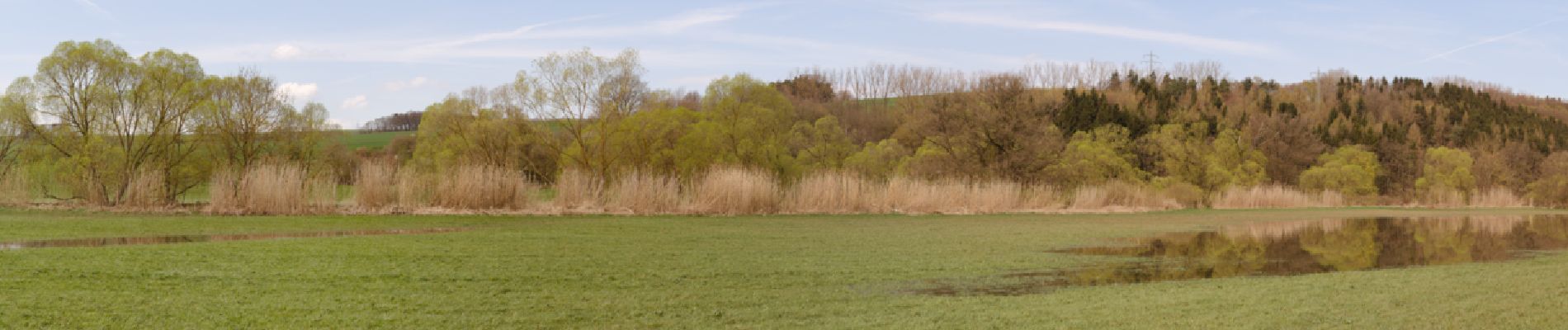
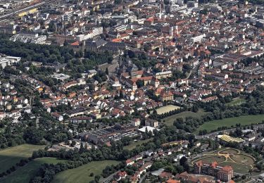
Trail On foot of 18.8 km to be discovered at Hesse, Landkreis Fulda, Fulda. This trail is proposed by SityTrail - itinéraires balisés pédestres.
Description
Trail created by Rhönklub.
Ist das der richtige Anfangs- und Endpunkt? Gibt es bei einem Rundweg überhaupt einen definierten Anfang und Ende?
Symbol: green filled pointer
Positioning
Country:
Germany
Region :
Hesse
Department/Province :
Landkreis Fulda
Municipality :
Fulda
Location:
Unknown
Start:(Dec)
Start:(UTM)
548186 ; 5596229 (32U) N.
Comments
Trails nearby
![Trail On foot Fulda - Schulzenberg Rundwanderweg - Photo](https://media.geolcdn.com/t/375/260/ext.jpg?maxdim=2&url=https%3A%2F%2Fmedia.geolcdn.com%2Ff%2Fcbf19f31-4dda-4b83-ae14-ae0aab87b8a0.jpeg)
![On foot On foot](https://static1.geolcdn.com/sitytour/trail-icons/100.png)
Schulzenberg Rundwanderweg
On foot
Easy
Fulda,
Hesse,
Landkreis Fulda,
Germany
![](/images/other/stat-length.png)
3.8 km | 4.9 km-effort
1h 7min
![](https://static1.geolcdn.com/siteimages/upload/files/16400158638029165_repeat_loop_refresh_sync_direction_icon.png)
Yes
![Trail On foot Petersberg - Petersberg 5 - Photo](https://media.geolcdn.com/t/375/260/ext.jpg?maxdim=2&url=https%3A%2F%2Fmedia.geolcdn.com%2Ff%2F4300808c-9e80-4d41-ac4a-3253da79edb4.jpeg)
![On foot On foot](https://static1.geolcdn.com/sitytour/trail-icons/100.png)
Petersberg 5
On foot
Easy
Petersberg,
Hesse,
Landkreis Fulda,
Germany
![](/images/other/stat-length.png)
9 km | 10 km-effort
2h 16min
![](https://static1.geolcdn.com/siteimages/upload/files/16400158638029165_repeat_loop_refresh_sync_direction_icon.png)
No
![Trail On foot Künzell - Petersberg 4 - Photo](https://media.geolcdn.com/t/375/260/ext.jpg?maxdim=2&url=https%3A%2F%2Fstatic1.geolcdn.com%2Fsiteimages%2Fupload%2Ffiles%2F1545311037marcheuse_200dpi.jpg)
![On foot On foot](https://static1.geolcdn.com/sitytour/trail-icons/100.png)
![Trail On foot Eichenzell - Eichenzell 1 - Photo](https://media.geolcdn.com/t/375/260/ext.jpg?maxdim=2&url=https%3A%2F%2Fstatic1.geolcdn.com%2Fsiteimages%2Fupload%2Ffiles%2F1545311037marcheuse_200dpi.jpg)
![On foot On foot](https://static1.geolcdn.com/sitytour/trail-icons/100.png)
Eichenzell 1
On foot
Easy
Eichenzell,
Hesse,
Landkreis Fulda,
Germany
![](/images/other/stat-length.png)
3.7 km | 4.2 km-effort
57min
![](https://static1.geolcdn.com/siteimages/upload/files/16400158638029165_repeat_loop_refresh_sync_direction_icon.png)
No
![Trail On foot Eichenzell - Eichenzell 4 - Photo](https://media.geolcdn.com/t/375/260/ext.jpg?maxdim=2&url=https%3A%2F%2Fstatic1.geolcdn.com%2Fsiteimages%2Fupload%2Ffiles%2F1545311037marcheuse_200dpi.jpg)
![On foot On foot](https://static1.geolcdn.com/sitytour/trail-icons/100.png)
Eichenzell 4
On foot
Easy
Eichenzell,
Hesse,
Landkreis Fulda,
Germany
![](/images/other/stat-length.png)
4.9 km | 6.7 km-effort
1h 31min
![](https://static1.geolcdn.com/siteimages/upload/files/16400158638029165_repeat_loop_refresh_sync_direction_icon.png)
No
![Trail On foot Eichenzell - Eichenzell 11 - Photo](https://media.geolcdn.com/t/375/260/ext.jpg?maxdim=2&url=https%3A%2F%2Fstatic1.geolcdn.com%2Fsiteimages%2Fupload%2Ffiles%2F1545311037marcheuse_200dpi.jpg)
![On foot On foot](https://static1.geolcdn.com/sitytour/trail-icons/100.png)
Eichenzell 11
On foot
Easy
Eichenzell,
Hesse,
Landkreis Fulda,
Germany
![](/images/other/stat-length.png)
3.5 km | 3.8 km-effort
51min
![](https://static1.geolcdn.com/siteimages/upload/files/16400158638029165_repeat_loop_refresh_sync_direction_icon.png)
Yes