


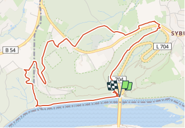

22 km | 29 km-effort
![Trail On foot Unknown - [S3] Klusenbergrundweg - Photo](https://media.geolcdn.com/t/1900/400/48a0ef8e-3704-4b57-a4cf-02a57ebc2595.jpeg&format=pjpeg&maxdim=2)

Tous les sentiers balisés d’Europe GUIDE+


FREE GPS app for hiking
 SityTrail
IGN / Geographical institutes
SityTrail World
The world is yours!
Trail On foot of 5.6 km to be discovered at North Rhine-Westphalia, Dortmund, Unknown. This trail is proposed by SityTrail - itinéraires balisés pédestres.
Trail created by Sauerländischer Gebirgsverein Bezirk Dortmund Ardey.
![Trail On foot Unknown - [S3] Klusenbergrundweg - Photo 1](https://media.geolcdn.com/t/2048/auto/d04de6fd-0958-4350-85f9-f3551839db39.jpeg&format=jpg&maxdim=0 "Trail On foot Unknown - [S3] Klusenbergrundweg - Photo 1")
![Trail On foot Unknown - [S3] Klusenbergrundweg - Photo 2](https://media.geolcdn.com/t/2048/auto/26483a33-7972-46d2-b387-1dba689e4068.jpeg&format=jpg&maxdim=0 "Trail On foot Unknown - [S3] Klusenbergrundweg - Photo 2")
![Trail On foot Unknown - [S3] Klusenbergrundweg - Photo 3](https://media.geolcdn.com/t/2048/auto/cc30ea1e-bb34-451e-8e44-cecbdcc6b53e.jpeg&format=jpg&maxdim=0 "Trail On foot Unknown - [S3] Klusenbergrundweg - Photo 3")
![Trail On foot Unknown - [S3] Klusenbergrundweg - Photo 4](https://media.geolcdn.com/t/2048/auto/aa9b25e0-9594-4d0b-8fe4-290cbfb83280.jpeg&format=jpg&maxdim=0 "Trail On foot Unknown - [S3] Klusenbergrundweg - Photo 4")
![Trail On foot Unknown - [S3] Klusenbergrundweg - Photo 5](https://media.geolcdn.com/t/2048/auto/a32380c4-34b1-4657-9a5d-e35f0efcc9cc.jpeg&format=jpg&maxdim=0 "Trail On foot Unknown - [S3] Klusenbergrundweg - Photo 5")
![Trail On foot Unknown - [S3] Klusenbergrundweg - Photo 6](https://media.geolcdn.com/t/2048/auto/ddfb5857-138c-4fff-b388-dfb8e6b159bb.jpeg&format=jpg&maxdim=0 "Trail On foot Unknown - [S3] Klusenbergrundweg - Photo 6")
![Trail On foot Unknown - [S3] Klusenbergrundweg - Photo 7](https://media.geolcdn.com/t/2048/auto/48a0ef8e-3704-4b57-a4cf-02a57ebc2595.jpeg&format=jpg&maxdim=0 "Trail On foot Unknown - [S3] Klusenbergrundweg - Photo 7")
![Trail On foot Unknown - [S3] Klusenbergrundweg - Photo 8](https://media.geolcdn.com/t/2048/auto/70870b1f-bdbf-4566-907b-1a90fced8cd9.jpeg&format=jpg&maxdim=0 "Trail On foot Unknown - [S3] Klusenbergrundweg - Photo 8")
![Trail On foot Unknown - [S3] Klusenbergrundweg - Photo 9](https://media.geolcdn.com/t/2048/auto/5593201d-8896-4be9-a1fd-95978bfbd527.jpeg&format=jpg&maxdim=0 "Trail On foot Unknown - [S3] Klusenbergrundweg - Photo 9")
![Trail On foot Unknown - [S3] Klusenbergrundweg - Photo 10](https://media.geolcdn.com/t/2048/auto/1b3980e0-b790-4536-88b5-c06efdfdb484.jpeg&format=jpg&maxdim=0 "Trail On foot Unknown - [S3] Klusenbergrundweg - Photo 10")
![Trail On foot Herdecke - [H6] Waldgebiete - Photo](https://media.geolcdn.com/t/375/260/fc184e54-a300-4080-bfb1-ee5af7544b8a.jpeg&format=jpg&maxdim=2)
On foot
![Trail On foot Herdecke - [H5] Westende - Kirchende - Ostende - Photo](https://media.geolcdn.com/t/375/260/a4190d68-4b9d-4b0c-86e3-91419be4a223.jpeg&format=jpg&maxdim=2)
On foot
![Trail On foot Herdecke - [H3] Hengsteysee und Teufelskanzel - Photo](https://media.geolcdn.com/t/375/260/48a0ef8e-3704-4b57-a4cf-02a57ebc2595.jpeg&format=jpg&maxdim=2)
On foot
![Trail On foot Herdecke - [H2] Ruhrtal zum Hickenstein - Photo](https://media.geolcdn.com/t/375/260/47dfa9a4-572d-4f34-b111-ae10e112c377.jpeg&format=jpg&maxdim=2)
On foot
![Trail On foot Herdecke - [H1] Viadukt und Nacken - Photo](https://media.geolcdn.com/t/375/260/0816fcff-a194-4a3a-b211-f59c276124fc.jpeg&format=jpg&maxdim=2)
On foot
On foot
On foot
On foot
On foot