![](/images/other/stat-length.png)
![Trail On foot Losheim am See - Tafeltour - Photo](https://media.geolcdn.com/t/1900/400/ext.pjpeg?maxdim=2&url=https%3A%2F%2Fmedia.geolcdn.com%2Ff%2F8ef22c85-1d94-40b0-95aa-29761b54f676.jpeg)
Tafeltour
SityTrail - itinéraires balisés pédestres
Tous les sentiers balisés d’Europe PRO
![Length](/images/other/stat-length.png)
Length
9.7 km
![Max alt](https://static1.geolcdn.com/siteimages/upload/files/1508320355ic_sort_altitude_max_24dp.png)
Max alt
490 m
![Uphill gradient](https://static1.geolcdn.com/siteimages/upload/files/1508320355ic_sort_den_pos_24dp.png)
Uphill gradient
236 m
![Km-Effort](/images/other/stat-length.png)
Km-Effort
12.9 km
![Min alt](https://static1.geolcdn.com/siteimages/upload/files/1508320355ic_sort_altitude_min_24dp.png)
Min alt
319 m
![Downhill gradient](https://static1.geolcdn.com/siteimages/upload/files/1508320355ic_sort_den_neg_24dp.png)
Downhill gradient
254 m
![Boucle](https://static1.geolcdn.com/siteimages/upload/files/16400158638029165_repeat_loop_refresh_sync_direction_icon.png)
Boucle
No
Signpost
Creation date :
2022-02-11 13:32:31.108
Updated on :
2022-02-11 13:32:31.108
![On foot](https://static1.geolcdn.com/sitytour/trail-icons/100.png)
2h55
Difficulty : Easy
![Scan this QR Code to open this trail in the SityTrail application](https://capi.geolives.com/qq0zvz2zws4bq2lad0pu/sitytour/trails/3090487/qr.png?size=200)
FREE GPS app for hiking
About
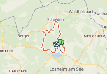
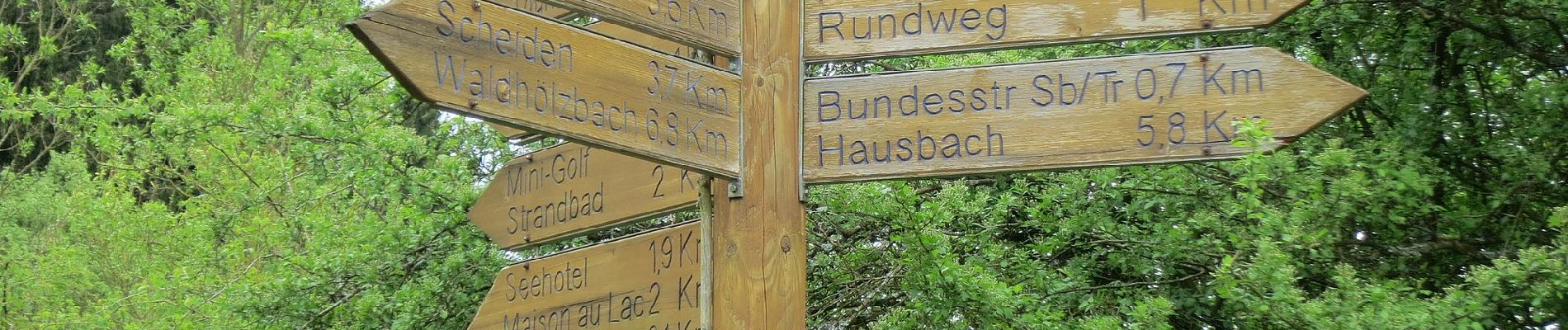
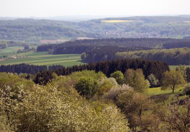
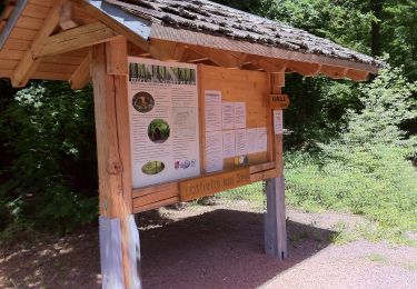
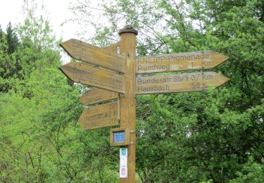
Trail On foot of 9.7 km to be discovered at Saarland, Landkreis Merzig-Wadern, Losheim am See. This trail is proposed by SityTrail - itinéraires balisés pédestres.
Description
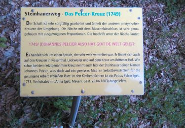
Trail created by Projektbüro Saar-Hunsrück-Steig.
Traumschleife des Saar-Hunsrück-Steigs
Positioning
Country:
Germany
Region :
Saarland
Department/Province :
Landkreis Merzig-Wadern
Municipality :
Losheim am See
Location:
Losheim am See
Start:(Dec)
Start:(UTM)
335974 ; 5488145 (32U) N.
Comments
Trails nearby
![Trail On foot Losheim am See - Waldsaumweg - Photo](https://media.geolcdn.com/t/375/260/ext.jpg?maxdim=2&url=https%3A%2F%2Fmedia.geolcdn.com%2Ff%2F619ba0cc-99dc-401f-9234-9f002ae39ed3.jpeg)
![On foot On foot](https://static1.geolcdn.com/sitytour/trail-icons/100.png)
Waldsaumweg
On foot
Easy
Losheim am See,
Saarland,
Landkreis Merzig-Wadern,
Germany
![](/images/other/stat-length.png)
10 km | 13.6 km-effort
3h 4min
![](https://static1.geolcdn.com/siteimages/upload/files/16400158638029165_repeat_loop_refresh_sync_direction_icon.png)
Yes
![Trail On foot Weiskirchen - 2-Täler-Weg - Photo](https://media.geolcdn.com/t/375/260/ext.jpg?maxdim=2&url=https%3A%2F%2Fmedia.geolcdn.com%2Ff%2Ffc139615-f271-4cce-a6cc-ae4afbe0241f.jpeg)
![On foot On foot](https://static1.geolcdn.com/sitytour/trail-icons/100.png)
2-Täler-Weg
On foot
Easy
Weiskirchen,
Saarland,
Landkreis Merzig-Wadern,
Germany
![](/images/other/stat-length.png)
8.2 km | 11.3 km-effort
2h 34min
![](https://static1.geolcdn.com/siteimages/upload/files/16400158638029165_repeat_loop_refresh_sync_direction_icon.png)
No
![Trail On foot Losheim am See - Steinhauerweg - Photo](https://media.geolcdn.com/t/375/260/ext.jpg?maxdim=2&url=https%3A%2F%2Fmedia.geolcdn.com%2Ff%2Fc399055f-d88a-4132-9ad1-7de1082fe034.jpeg)
![On foot On foot](https://static1.geolcdn.com/sitytour/trail-icons/100.png)
Steinhauerweg
On foot
Easy
Losheim am See,
Saarland,
Landkreis Merzig-Wadern,
Germany
![](/images/other/stat-length.png)
10.1 km | 13.2 km-effort
3h 0min
![](https://static1.geolcdn.com/siteimages/upload/files/16400158638029165_repeat_loop_refresh_sync_direction_icon.png)
Yes
![Trail On foot Greimerath - RuT3 - Photo](https://media.geolcdn.com/t/375/260/ext.jpg?maxdim=2&url=https%3A%2F%2Fmedia.geolcdn.com%2Ff%2F0e82cc95-177f-4476-840a-9e9b6d408716.jpeg)
![On foot On foot](https://static1.geolcdn.com/sitytour/trail-icons/100.png)
RuT3
On foot
Easy
Greimerath,
Rhineland-Palatinate,
Landkreis Trier-Saarburg,
Germany
![](/images/other/stat-length.png)
6.7 km | 8.6 km-effort
1h 57min
![](https://static1.geolcdn.com/siteimages/upload/files/16400158638029165_repeat_loop_refresh_sync_direction_icon.png)
Yes
![Trail On foot Losheim am See - Stauseerundweg - Photo](https://media.geolcdn.com/t/375/260/ext.jpg?maxdim=2&url=https%3A%2F%2Fmedia.geolcdn.com%2Ff%2F6c88a7bf-e1ab-4c12-bb6b-23ceeb490663.jpeg)
![On foot On foot](https://static1.geolcdn.com/sitytour/trail-icons/100.png)
Stauseerundweg
On foot
Easy
Losheim am See,
Saarland,
Landkreis Merzig-Wadern,
Germany
![](/images/other/stat-length.png)
3.8 km | 4.7 km-effort
1h 4min
![](https://static1.geolcdn.com/siteimages/upload/files/16400158638029165_repeat_loop_refresh_sync_direction_icon.png)
Yes
![Trail On foot Losheim am See - Oppig-Grät-Weg - Photo](https://media.geolcdn.com/t/375/260/ext.jpg?maxdim=2&url=https%3A%2F%2Fmedia.geolcdn.com%2Ff%2F8c5067b1-77b3-49a7-9635-b694a9f36ec0.jpeg)
![On foot On foot](https://static1.geolcdn.com/sitytour/trail-icons/100.png)
Oppig-Grät-Weg
On foot
Easy
Losheim am See,
Saarland,
Landkreis Merzig-Wadern,
Germany
![](/images/other/stat-length.png)
11.3 km | 16.3 km-effort
3h 42min
![](https://static1.geolcdn.com/siteimages/upload/files/16400158638029165_repeat_loop_refresh_sync_direction_icon.png)
Yes
![Trail On foot Losheim am See - Der Bergener - Photo](https://media.geolcdn.com/t/375/260/ext.jpg?maxdim=2&url=https%3A%2F%2Fmedia.geolcdn.com%2Ff%2F8ef22c85-1d94-40b0-95aa-29761b54f676.jpeg)
![On foot On foot](https://static1.geolcdn.com/sitytour/trail-icons/100.png)
Der Bergener
On foot
Easy
Losheim am See,
Saarland,
Landkreis Merzig-Wadern,
Germany
![](/images/other/stat-length.png)
11.1 km | 14.7 km-effort
3h 19min
![](https://static1.geolcdn.com/siteimages/upload/files/16400158638029165_repeat_loop_refresh_sync_direction_icon.png)
Yes
![Trail On foot Weiskirchen - Wildkatzenpfad - Photo](https://media.geolcdn.com/t/375/260/ext.jpg?maxdim=2&url=https%3A%2F%2Fstatic1.geolcdn.com%2Fsiteimages%2Fupload%2Ffiles%2F1545311037marcheuse_200dpi.jpg)
![On foot On foot](https://static1.geolcdn.com/sitytour/trail-icons/100.png)
Wildkatzenpfad
On foot
Easy
Weiskirchen,
Saarland,
Landkreis Merzig-Wadern,
Germany
![](/images/other/stat-length.png)
4.4 km | 5.8 km-effort
1h 19min
![](https://static1.geolcdn.com/siteimages/upload/files/16400158638029165_repeat_loop_refresh_sync_direction_icon.png)
No
![Trail On foot Losheim am See - Georgi Panoramaweg - Photo](https://media.geolcdn.com/t/375/260/ext.jpg?maxdim=2&url=https%3A%2F%2Fstatic1.geolcdn.com%2Fsiteimages%2Fupload%2Ffiles%2F1545311037marcheuse_200dpi.jpg)
![On foot On foot](https://static1.geolcdn.com/sitytour/trail-icons/100.png)
Georgi Panoramaweg
On foot
Easy
Losheim am See,
Saarland,
Landkreis Merzig-Wadern,
Germany
![](/images/other/stat-length.png)
8.5 km | 10.6 km-effort
2h 24min
![](https://static1.geolcdn.com/siteimages/upload/files/16400158638029165_repeat_loop_refresh_sync_direction_icon.png)
No