![](/images/other/stat-length.png)
![Trail On foot Wetter (Ruhr) - (HW) Harkort-Weg - Photo](https://media.geolcdn.com/t/1900/400/eb1871ff-2bb4-4414-81a6-d75924cc1cb9.jpeg&format=pjpeg&maxdim=2)
(HW) Harkort-Weg
SityTrail - itinéraires balisés pédestres
Tous les sentiers balisés d’Europe GUIDE+
![Length](/images/other/stat-length.png)
Length
3.2 km
![Max alt](https://static1.geolcdn.com/siteimages/upload/files/1508320355ic_sort_altitude_max_24dp.png)
Max alt
237 m
![Uphill gradient](https://static1.geolcdn.com/siteimages/upload/files/1508320355ic_sort_den_pos_24dp.png)
Uphill gradient
122 m
![Km-Effort](/images/other/stat-length.png)
Km-Effort
4.9 km
![Min alt](https://static1.geolcdn.com/siteimages/upload/files/1508320355ic_sort_altitude_min_24dp.png)
Min alt
95 m
![Downhill gradient](https://static1.geolcdn.com/siteimages/upload/files/1508320355ic_sort_den_neg_24dp.png)
Downhill gradient
143 m
![Boucle](https://static1.geolcdn.com/siteimages/upload/files/16400158638029165_repeat_loop_refresh_sync_direction_icon.png)
Boucle
No
Signpost
Creation date :
2022-02-11 13:28:39.753
Updated on :
2022-02-11 13:28:39.753
![On foot](https://static1.geolcdn.com/sitytour/trail-icons/100.png)
1h07
Difficulty : Easy
![Scan this QR Code to open this trail in the SityTrail application](https://capi.geolives.com/qq0zvz2zws4bq2lad0pu/sitytour/trails/3090422/qr.png?size=200)
FREE GPS app for hiking
About
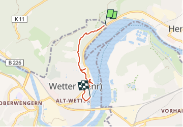
Trail On foot of 3.2 km to be discovered at North Rhine-Westphalia, Ennepe-Ruhr-Kreis, Wetter (Ruhr). This trail is proposed by SityTrail - itinéraires balisés pédestres.
Description
Trail created by Stadtmarketingverein Wetter.
Website: https://www.stadtmarketing-wetter.de/
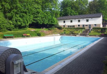
Positioning
Country:
Germany
Region :
North Rhine-Westphalia
Department/Province :
Ennepe-Ruhr-Kreis
Municipality :
Wetter (Ruhr)
Location:
Unknown
Start:(Dec)
Start:(UTM)
389052 ; 5695584 (32U) N.
Comments
Trails nearby
![Trail On foot Herdecke - [H6] Waldgebiete - Photo](https://media.geolcdn.com/t/375/260/fc184e54-a300-4080-bfb1-ee5af7544b8a.jpeg&format=jpg&maxdim=2)
![On foot On foot](https://static1.geolcdn.com/sitytour/trail-icons/100.png)
[H6] Waldgebiete
On foot
Medium
Herdecke,
North Rhine-Westphalia,
Ennepe-Ruhr-Kreis,
Germany
![](/images/other/stat-length.png)
22 km | 29 km-effort
6h 34min
![](https://static1.geolcdn.com/siteimages/upload/files/16400158638029165_repeat_loop_refresh_sync_direction_icon.png)
Yes
![Trail On foot Herdecke - [H5] Westende - Kirchende - Ostende - Photo](https://media.geolcdn.com/t/375/260/a4190d68-4b9d-4b0c-86e3-91419be4a223.jpeg&format=jpg&maxdim=2)
![On foot On foot](https://static1.geolcdn.com/sitytour/trail-icons/100.png)
[H5] Westende - Kirchende - Ostende
On foot
Medium
Herdecke,
North Rhine-Westphalia,
Ennepe-Ruhr-Kreis,
Germany
![](/images/other/stat-length.png)
17.7 km | 24 km-effort
5h 25min
![](https://static1.geolcdn.com/siteimages/upload/files/16400158638029165_repeat_loop_refresh_sync_direction_icon.png)
Yes
![Trail On foot Herdecke - [H3] Hengsteysee und Teufelskanzel - Photo](https://media.geolcdn.com/t/375/260/48a0ef8e-3704-4b57-a4cf-02a57ebc2595.jpeg&format=jpg&maxdim=2)
![On foot On foot](https://static1.geolcdn.com/sitytour/trail-icons/100.png)
[H3] Hengsteysee und Teufelskanzel
On foot
Easy
Herdecke,
North Rhine-Westphalia,
Ennepe-Ruhr-Kreis,
Germany
![](/images/other/stat-length.png)
6.7 km | 9.1 km-effort
2h 3min
![](https://static1.geolcdn.com/siteimages/upload/files/16400158638029165_repeat_loop_refresh_sync_direction_icon.png)
No
![Trail On foot Herdecke - [H2] Ruhrtal zum Hickenstein - Photo](https://media.geolcdn.com/t/375/260/47dfa9a4-572d-4f34-b111-ae10e112c377.jpeg&format=jpg&maxdim=2)
![On foot On foot](https://static1.geolcdn.com/sitytour/trail-icons/100.png)
[H2] Ruhrtal zum Hickenstein
On foot
Easy
Herdecke,
North Rhine-Westphalia,
Ennepe-Ruhr-Kreis,
Germany
![](/images/other/stat-length.png)
8.4 km | 12.2 km-effort
2h 45min
![](https://static1.geolcdn.com/siteimages/upload/files/16400158638029165_repeat_loop_refresh_sync_direction_icon.png)
Yes
![Trail On foot Herdecke - [H1] Viadukt und Nacken - Photo](https://media.geolcdn.com/t/375/260/0816fcff-a194-4a3a-b211-f59c276124fc.jpeg&format=jpg&maxdim=2)
![On foot On foot](https://static1.geolcdn.com/sitytour/trail-icons/100.png)
[H1] Viadukt und Nacken
On foot
Easy
Herdecke,
North Rhine-Westphalia,
Ennepe-Ruhr-Kreis,
Germany
![](/images/other/stat-length.png)
5.3 km | 7.6 km-effort
1h 43min
![](https://static1.geolcdn.com/siteimages/upload/files/16400158638029165_repeat_loop_refresh_sync_direction_icon.png)
Yes
![Trail On foot Herdecke - (H) Rund um Herdecke - Photo](https://media.geolcdn.com/t/375/260/3a47b9d1-1b31-4b2d-8f31-3d9786e651b8.jpeg&format=jpg&maxdim=2)
![On foot On foot](https://static1.geolcdn.com/sitytour/trail-icons/100.png)
(H) Rund um Herdecke
On foot
Difficult
Herdecke,
North Rhine-Westphalia,
Ennepe-Ruhr-Kreis,
Germany
![](/images/other/stat-length.png)
27 km | 35 km-effort
7h 57min
![](https://static1.geolcdn.com/siteimages/upload/files/16400158638029165_repeat_loop_refresh_sync_direction_icon.png)
Yes
![Trail On foot Herdecke - Energiewirtschaftlicher Wanderweg - Photo](https://media.geolcdn.com/t/375/260/0816fcff-a194-4a3a-b211-f59c276124fc.jpeg&format=jpg&maxdim=2)
![On foot On foot](https://static1.geolcdn.com/sitytour/trail-icons/100.png)
Energiewirtschaftlicher Wanderweg
On foot
Easy
Herdecke,
North Rhine-Westphalia,
Ennepe-Ruhr-Kreis,
Germany
![](/images/other/stat-length.png)
3.7 km | 4.3 km-effort
58min
![](https://static1.geolcdn.com/siteimages/upload/files/16400158638029165_repeat_loop_refresh_sync_direction_icon.png)
No
![Trail On foot Wetter (Ruhr) - Auf den Spuren Gustav Vorstehers - Photo](https://media.geolcdn.com/t/375/260/6650b932-7f62-41ca-99e0-7a8de169d7d3.jpeg&format=jpg&maxdim=2)
![On foot On foot](https://static1.geolcdn.com/sitytour/trail-icons/100.png)
Auf den Spuren Gustav Vorstehers
On foot
Easy
Wetter (Ruhr),
North Rhine-Westphalia,
Ennepe-Ruhr-Kreis,
Germany
![](/images/other/stat-length.png)
3.6 km | 4.6 km-effort
1h 2min
![](https://static1.geolcdn.com/siteimages/upload/files/16400158638029165_repeat_loop_refresh_sync_direction_icon.png)
Yes
![Trail On foot Wetter (Ruhr) - Erbstollenweg - Photo](https://media.geolcdn.com/t/375/260/b3b2b259-90e3-4aa5-8d2c-d44b2040b229.jpeg&format=jpg&maxdim=2)
![On foot On foot](https://static1.geolcdn.com/sitytour/trail-icons/100.png)
Erbstollenweg
On foot
Easy
Wetter (Ruhr),
North Rhine-Westphalia,
Ennepe-Ruhr-Kreis,
Germany
![](/images/other/stat-length.png)
8.8 km | 12.3 km-effort
2h 48min
![](https://static1.geolcdn.com/siteimages/upload/files/16400158638029165_repeat_loop_refresh_sync_direction_icon.png)
No