![](/images/other/stat-length.png)
![Trail On foot Unknown - Eichlinghofen Rundweg A2 - Photo](https://media.geolcdn.com/t/1900/400/1835a1cf-2980-450c-aadc-b2522cbd8fee.jpeg&format=pjpeg&maxdim=2)
Eichlinghofen Rundweg A2
SityTrail - itinéraires balisés pédestres
Tous les sentiers balisés d’Europe GUIDE+
![Length](/images/other/stat-length.png)
Length
6.1 km
![Max alt](https://static1.geolcdn.com/siteimages/upload/files/1508320355ic_sort_altitude_max_24dp.png)
Max alt
139 m
![Uphill gradient](https://static1.geolcdn.com/siteimages/upload/files/1508320355ic_sort_den_pos_24dp.png)
Uphill gradient
73 m
![Km-Effort](/images/other/stat-length.png)
Km-Effort
7.1 km
![Min alt](https://static1.geolcdn.com/siteimages/upload/files/1508320355ic_sort_altitude_min_24dp.png)
Min alt
104 m
![Downhill gradient](https://static1.geolcdn.com/siteimages/upload/files/1508320355ic_sort_den_neg_24dp.png)
Downhill gradient
73 m
![Boucle](https://static1.geolcdn.com/siteimages/upload/files/16400158638029165_repeat_loop_refresh_sync_direction_icon.png)
Boucle
Yes
Signpost
Creation date :
2022-02-11 13:22:02.232
Updated on :
2022-02-11 13:22:02.232
![On foot](https://static1.geolcdn.com/sitytour/trail-icons/100.png)
1h36
Difficulty : Easy
![Scan this QR Code to open this trail in the SityTrail application](https://capi.geolives.com/qq0zvz2zws4bq2lad0pu/sitytour/trails/3090104/qr.png?size=200)
FREE GPS app for hiking
About
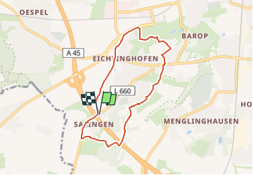
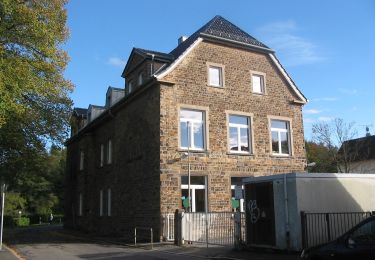
Trail On foot of 6.1 km to be discovered at North Rhine-Westphalia, Dortmund, Unknown. This trail is proposed by SityTrail - itinéraires balisés pédestres.
Description
Trail created by Sauerländischer Gebirgsverein Bezirk Dortmund Ardey.
Symbol: weißes A2 auf schwarzem Grund
Positioning
Country:
Germany
Region :
North Rhine-Westphalia
Department/Province :
Dortmund
Municipality :
Unknown
Location:
Hombruch
Start:(Dec)
Start:(UTM)
388724 ; 5703722 (32U) N.
Comments
Trails nearby
![Trail On foot Witten - [Δ] Witten - Grundschöttel - Photo](https://media.geolcdn.com/t/375/260/2e64de42-6724-4fef-8c50-11bf465b833c.jpeg&format=jpg&maxdim=2)
![On foot On foot](https://static1.geolcdn.com/sitytour/trail-icons/100.png)
[Δ] Witten - Grundschöttel
On foot
Medium
Witten,
North Rhine-Westphalia,
Ennepe-Ruhr-Kreis,
Germany
![](/images/other/stat-length.png)
18 km | 23 km-effort
5h 15min
![](https://static1.geolcdn.com/siteimages/upload/files/16400158638029165_repeat_loop_refresh_sync_direction_icon.png)
No
![Trail On foot Unknown - Löttringhausen Rundweg A4 - Photo](https://media.geolcdn.com/t/375/260/1cd5c06e-e244-4763-9306-8b5d1f9bc187.jpeg&format=jpg&maxdim=2)
![On foot On foot](https://static1.geolcdn.com/sitytour/trail-icons/100.png)
Löttringhausen Rundweg A4
On foot
Easy
Unknown,
North Rhine-Westphalia,
Dortmund,
Germany
![](/images/other/stat-length.png)
8.2 km | 10.9 km-effort
2h 28min
![](https://static1.geolcdn.com/siteimages/upload/files/16400158638029165_repeat_loop_refresh_sync_direction_icon.png)
Yes
![Trail On foot Unknown - Lütgendortmund Rundweg A3 - Photo](https://media.geolcdn.com/t/375/260/94efa19f-9034-49d4-ac68-23b935d7f8d3.jpeg&format=jpg&maxdim=2)
![On foot On foot](https://static1.geolcdn.com/sitytour/trail-icons/100.png)
Lütgendortmund Rundweg A3
On foot
Easy
Unknown,
North Rhine-Westphalia,
Dortmund,
Germany
![](/images/other/stat-length.png)
9 km | 10.4 km-effort
2h 21min
![](https://static1.geolcdn.com/siteimages/upload/files/16400158638029165_repeat_loop_refresh_sync_direction_icon.png)
Yes
![Trail On foot Unknown - Lütgendortmund Rundweg A2 - Photo](https://media.geolcdn.com/t/375/260/74fcc15b-562e-46cd-bd7b-1babd48cb994.jpeg&format=jpg&maxdim=2)
![On foot On foot](https://static1.geolcdn.com/sitytour/trail-icons/100.png)
Lütgendortmund Rundweg A2
On foot
Easy
Unknown,
North Rhine-Westphalia,
Dortmund,
Germany
![](/images/other/stat-length.png)
3.4 km | 4.2 km-effort
57min
![](https://static1.geolcdn.com/siteimages/upload/files/16400158638029165_repeat_loop_refresh_sync_direction_icon.png)
Yes
![Trail On foot Witten - Herrenholz Rundweg A2 - Photo](https://media.geolcdn.com/t/375/260/8e7682b8-eb5c-4af9-b8d0-14ab1e7e1477.jpeg&format=jpg&maxdim=2)
![On foot On foot](https://static1.geolcdn.com/sitytour/trail-icons/100.png)
Herrenholz Rundweg A2
On foot
Easy
Witten,
North Rhine-Westphalia,
Ennepe-Ruhr-Kreis,
Germany
![](/images/other/stat-length.png)
5.4 km | 7.1 km-effort
1h 36min
![](https://static1.geolcdn.com/siteimages/upload/files/16400158638029165_repeat_loop_refresh_sync_direction_icon.png)
Yes
![Trail On foot Witten - Stockum Rundweg A1 - Photo](https://media.geolcdn.com/t/375/260/42acc005-69be-471a-873a-b9e19fca34a5.jpeg&format=jpg&maxdim=2)
![On foot On foot](https://static1.geolcdn.com/sitytour/trail-icons/100.png)
Stockum Rundweg A1
On foot
Easy
Witten,
North Rhine-Westphalia,
Ennepe-Ruhr-Kreis,
Germany
![](/images/other/stat-length.png)
12.2 km | 14.4 km-effort
3h 16min
![](https://static1.geolcdn.com/siteimages/upload/files/16400158638029165_repeat_loop_refresh_sync_direction_icon.png)
Yes
![Trail On foot Witten - H Witten Hbf - Steigerhaus - Photo](https://media.geolcdn.com/t/375/260/d8ca2006-ec90-4209-bb62-47da32955e9d.jpeg&format=jpg&maxdim=2)
![On foot On foot](https://static1.geolcdn.com/sitytour/trail-icons/100.png)
H Witten Hbf - Steigerhaus
On foot
Easy
Witten,
North Rhine-Westphalia,
Ennepe-Ruhr-Kreis,
Germany
![](/images/other/stat-length.png)
3.2 km | 4.2 km-effort
57min
![](https://static1.geolcdn.com/siteimages/upload/files/16400158638029165_repeat_loop_refresh_sync_direction_icon.png)
No
![Trail On foot Unknown - (W) Rund um Witten - Photo](https://media.geolcdn.com/t/375/260/1835a1cf-2980-450c-aadc-b2522cbd8fee.jpeg&format=jpg&maxdim=2)
![On foot On foot](https://static1.geolcdn.com/sitytour/trail-icons/100.png)
(W) Rund um Witten
On foot
Easy
Unknown,
North Rhine-Westphalia,
Bochum,
Germany
![](/images/other/stat-length.png)
9.3 km | 10.8 km-effort
2h 27min
![](https://static1.geolcdn.com/siteimages/upload/files/16400158638029165_repeat_loop_refresh_sync_direction_icon.png)
No
![Trail On foot Witten - Herrenholz Rundweg A1 - Photo](https://media.geolcdn.com/t/375/260/c25c3245-ef5f-4340-a2ff-b5e86233a2fa.jpeg&format=jpg&maxdim=2)
![On foot On foot](https://static1.geolcdn.com/sitytour/trail-icons/100.png)
Herrenholz Rundweg A1
On foot
Easy
Witten,
North Rhine-Westphalia,
Ennepe-Ruhr-Kreis,
Germany
![](/images/other/stat-length.png)
6.1 km | 8.3 km-effort
1h 52min
![](https://static1.geolcdn.com/siteimages/upload/files/16400158638029165_repeat_loop_refresh_sync_direction_icon.png)
Yes