Trail On foot Wolpertshausen - Spuren der Vergangenheit - Photo

Tous les sentiers balisés d’Europe PRO

© OpenStreetMap contributors
Length
Length
25 km
Max alt
Max alt
444 m
Uphill gradient
Uphill gradient
586 m
Km-Effort
Km-Effort  
33 km
Min alt
Min alt
250 m
Downhill gradient
Downhill gradient
583 m
Boucle
Boucle
Yes
Signpost
Signpost
Creation date :
2022-02-11 13:19:56.105
Updated on :
2022-02-11 13:19:56.105

(0 Reviews)

On foot
On foot
7h30
Difficulty : Difficult

Scan this QR Code to open this trail in the SityTrail application

FREE GPS app for hiking

Logo SityTrail SityTrail

IGN / Geographical institutes

Download SityTrail from the App Store Download SityTrail from Google Play

Logo SityTrail SityTrail World

The world is yours!

Download SityTrail from the App Store Download SityTrail from Google Play Download SityTrail on Huawei AppGallery

About

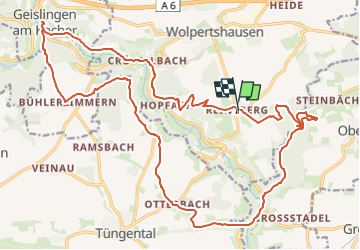
Trail On foot of 25 km to be discovered at Baden-Württemberg, Landkreis Schwäbisch Hall, Wolpertshausen. This trail is proposed by SityTrail - itinéraires balisés pédestres.

Description

Trail created by Bühlertal Tourismus.

Symbol: Mittig Großbuchstaben WS in brauner Schrift, klein rechts oben das Symbol des Bühlertales und unten der ausgeschriebene Name, Hintergrund weiß

Photos

Positioning

Country:
Germany
Region :
Baden-Württemberg
Department/Province :
Landkreis Schwäbisch Hall
Municipality :
Wolpertshausen
Location:
Unknown
Start:(UTM)
562243 ; 5444352 (32U) N.

Trails nearby

Trail On foot Ilshofen - Querlinie Oberscheffach - Ilshofen - Photo
On foot
PRO

On foot

Easy
Ilshofen, Baden-Württemberg, Landkreis Schwäbisch Hall, Germany
3.5 km | 5 km-effort
1h 8min
No


Close
My subscriptions