![](/images/other/stat-length.png)
![Trail On foot Paderborn - Josef-Schmitz-Weg - Photo](https://media.geolcdn.com/t/1900/400/1391abc3-8b8a-42a2-8b57-344bcbcce2df.jpeg&format=pjpeg&maxdim=2)
Josef-Schmitz-Weg
SityTrail - itinéraires balisés pédestres
Tous les sentiers balisés d’Europe GUIDE+
![Length](/images/other/stat-length.png)
Length
16.4 km
![Max alt](https://static1.geolcdn.com/siteimages/upload/files/1508320355ic_sort_altitude_max_24dp.png)
Max alt
330 m
![Uphill gradient](https://static1.geolcdn.com/siteimages/upload/files/1508320355ic_sort_den_pos_24dp.png)
Uphill gradient
246 m
![Km-Effort](/images/other/stat-length.png)
Km-Effort
19.9 km
![Min alt](https://static1.geolcdn.com/siteimages/upload/files/1508320355ic_sort_altitude_min_24dp.png)
Min alt
123 m
![Downhill gradient](https://static1.geolcdn.com/siteimages/upload/files/1508320355ic_sort_den_neg_24dp.png)
Downhill gradient
312 m
![Boucle](https://static1.geolcdn.com/siteimages/upload/files/16400158638029165_repeat_loop_refresh_sync_direction_icon.png)
Boucle
No
Signpost
Creation date :
2022-02-11 13:16:43.881
Updated on :
2022-02-11 13:16:43.881
![On foot](https://static1.geolcdn.com/sitytour/trail-icons/100.png)
4h31
Difficulty : Easy
![Scan this QR Code to open this trail in the SityTrail application](https://capi.geolives.com/qq0zvz2zws4bq2lad0pu/sitytour/trails/3089807/qr.png?size=200)
FREE GPS app for hiking
About
Trail On foot of 16.4 km to be discovered at North Rhine-Westphalia, Kreis Paderborn, Paderborn. This trail is proposed by SityTrail - itinéraires balisés pédestres.
Description
Trail created by EGV.
Symbol: white horizontal bar on black background
Positioning
Country:
Germany
Region :
North Rhine-Westphalia
Department/Province :
Kreis Paderborn
Municipality :
Paderborn
Location:
Unknown
Start:(Dec)
Start:(UTM)
490143 ; 5732804 (32U) N.
Comments
Trails nearby
![Trail On foot Paderborn - Walderlebnis-Pfad (Naturerbe Wanderwelt Altenbeken) - Photo](https://media.geolcdn.com/t/375/260/0d16f001-b35b-4172-b0d7-91dd2e576713.jpeg&format=jpg&maxdim=2)
![On foot On foot](https://static1.geolcdn.com/sitytour/trail-icons/100.png)
Walderlebnis-Pfad (Naturerbe Wanderwelt Altenbeken)
On foot
Easy
Paderborn,
North Rhine-Westphalia,
Kreis Paderborn,
Germany
![](/images/other/stat-length.png)
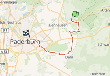
9.9 km | 13.7 km-effort
3h 6min
![](https://static1.geolcdn.com/siteimages/upload/files/16400158638029165_repeat_loop_refresh_sync_direction_icon.png)
Yes
![Trail On foot Paderborn - Naturerbe-Pfad (Naturerbe Wanderwelt Altenbeken) - Photo](https://media.geolcdn.com/t/375/260/6d7843fb-cfea-43da-9d8e-0cb024f142d4.jpeg&format=jpg&maxdim=2)
![On foot On foot](https://static1.geolcdn.com/sitytour/trail-icons/100.png)
Naturerbe-Pfad (Naturerbe Wanderwelt Altenbeken)
On foot
Easy
Paderborn,
North Rhine-Westphalia,
Kreis Paderborn,
Germany
![](/images/other/stat-length.png)
5 km | 7 km-effort
1h 35min
![](https://static1.geolcdn.com/siteimages/upload/files/16400158638029165_repeat_loop_refresh_sync_direction_icon.png)
No
![Trail On foot Altenbeken - Wildnis-Steig (Naturerbe Wanderwelt) - Photo](https://media.geolcdn.com/t/375/260/9c4178e1-ee32-4405-9caa-43b3b8afb5b7.jpeg&format=jpg&maxdim=2)
![On foot On foot](https://static1.geolcdn.com/sitytour/trail-icons/100.png)
Wildnis-Steig (Naturerbe Wanderwelt)
On foot
Medium
Altenbeken,
North Rhine-Westphalia,
Kreis Paderborn,
Germany
![](/images/other/stat-length.png)
23 km | 30 km-effort
6h 48min
![](https://static1.geolcdn.com/siteimages/upload/files/16400158638029165_repeat_loop_refresh_sync_direction_icon.png)
Yes
![Trail On foot Bad Lippspringe - Buchen-Wildnis-Pfad (Naturerbe Wanderwelt Altenbeken) - Photo](https://media.geolcdn.com/t/375/260/092b50ca-0a38-4367-9c3b-580ce26d07c4.jpeg&format=jpg&maxdim=2)
![On foot On foot](https://static1.geolcdn.com/sitytour/trail-icons/100.png)
Buchen-Wildnis-Pfad (Naturerbe Wanderwelt Altenbeken)
On foot
Easy
Bad Lippspringe,
North Rhine-Westphalia,
Kreis Paderborn,
Germany
![](/images/other/stat-length.png)
4.7 km | 6.3 km-effort
1h 25min
![](https://static1.geolcdn.com/siteimages/upload/files/16400158638029165_repeat_loop_refresh_sync_direction_icon.png)
Yes
![Trail On foot Bad Lippspringe - Delta (Bad Lippspringe) - Photo](https://media.geolcdn.com/t/375/260/092b50ca-0a38-4367-9c3b-580ce26d07c4.jpeg&format=jpg&maxdim=2)
![On foot On foot](https://static1.geolcdn.com/sitytour/trail-icons/100.png)
Delta (Bad Lippspringe)
On foot
Easy
Bad Lippspringe,
North Rhine-Westphalia,
Kreis Paderborn,
Germany
![](/images/other/stat-length.png)
4.9 km | 6.5 km-effort
1h 28min
![](https://static1.geolcdn.com/siteimages/upload/files/16400158638029165_repeat_loop_refresh_sync_direction_icon.png)
No
![Trail On foot Altenbeken - Durbeke-Steig (Naturerbe Wanderwelt Altenbeken) - Photo](https://media.geolcdn.com/t/375/260/01d02757-c856-4cdc-aee4-abafe2ca25b9.jpeg&format=jpg&maxdim=2)
![On foot On foot](https://static1.geolcdn.com/sitytour/trail-icons/100.png)
Durbeke-Steig (Naturerbe Wanderwelt Altenbeken)
On foot
Easy
Altenbeken,
North Rhine-Westphalia,
Kreis Paderborn,
Germany
![](/images/other/stat-length.png)
7.5 km | 9.8 km-effort
2h 13min
![](https://static1.geolcdn.com/siteimages/upload/files/16400158638029165_repeat_loop_refresh_sync_direction_icon.png)
No
![Trail On foot Altenbeken - Schwaneyer Panoramaweg - Photo](https://media.geolcdn.com/t/375/260/6677e685-b94e-4aaf-ac5f-a6be76346ebc.jpeg&format=jpg&maxdim=2)
![On foot On foot](https://static1.geolcdn.com/sitytour/trail-icons/100.png)
Schwaneyer Panoramaweg
On foot
Easy
Altenbeken,
North Rhine-Westphalia,
Kreis Paderborn,
Germany
![](/images/other/stat-length.png)
12.2 km | 16 km-effort
3h 38min
![](https://static1.geolcdn.com/siteimages/upload/files/16400158638029165_repeat_loop_refresh_sync_direction_icon.png)
No
![Trail On foot Paderborn - Rundweg Benhausen - Photo](https://media.geolcdn.com/t/375/260/2525b3f8-20b6-4a1b-a6d5-1753b3cff568.jpeg&format=jpg&maxdim=2)
![On foot On foot](https://static1.geolcdn.com/sitytour/trail-icons/100.png)
Rundweg Benhausen
On foot
Easy
Paderborn,
North Rhine-Westphalia,
Kreis Paderborn,
Germany
![](/images/other/stat-length.png)
9.1 km | 10.6 km-effort
2h 25min
![](https://static1.geolcdn.com/siteimages/upload/files/16400158638029165_repeat_loop_refresh_sync_direction_icon.png)
Yes
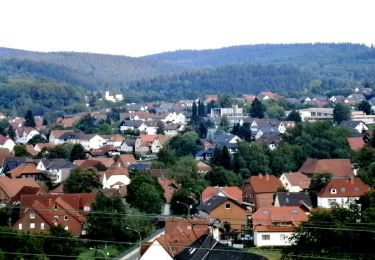
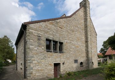
![Trail On foot Altenbeken - Rundwanderweg A2 [Altenbeken: Wienackenstraße] - Photo](https://media.geolcdn.com/t/375/260/ea5b2970-5dee-4d29-acc7-0d66cb0103a9.jpeg&format=jpg&maxdim=2)
![On foot On foot](https://static1.geolcdn.com/sitytour/trail-icons/100.png)
Rundwanderweg A2 [Altenbeken: Wienackenstraße]
On foot
Easy
Altenbeken,
North Rhine-Westphalia,
Kreis Paderborn,
Germany
![](/images/other/stat-length.png)
3.2 km | 4.3 km-effort
58min
![](https://static1.geolcdn.com/siteimages/upload/files/16400158638029165_repeat_loop_refresh_sync_direction_icon.png)
Yes