![](/images/other/stat-length.png)
![Trail On foot Heimbach - Klosterrunde - Photo](https://media.geolcdn.com/t/1900/400/bff8ca8c-867c-4335-bbdd-0941f75df916.jpeg&format=pjpeg&maxdim=2)
Klosterrunde
SityTrail - itinéraires balisés pédestres
Tous les sentiers balisés d’Europe GUIDE+
![Length](/images/other/stat-length.png)
![Max alt](https://static1.geolcdn.com/siteimages/upload/files/1508320355ic_sort_altitude_max_24dp.png)
![Uphill gradient](https://static1.geolcdn.com/siteimages/upload/files/1508320355ic_sort_den_pos_24dp.png)
![Km-Effort](/images/other/stat-length.png)
![Min alt](https://static1.geolcdn.com/siteimages/upload/files/1508320355ic_sort_altitude_min_24dp.png)
![Downhill gradient](https://static1.geolcdn.com/siteimages/upload/files/1508320355ic_sort_den_neg_24dp.png)
![Boucle](https://static1.geolcdn.com/siteimages/upload/files/16400158638029165_repeat_loop_refresh_sync_direction_icon.png)
![On foot](https://static1.geolcdn.com/sitytour/trail-icons/100.png)
2h56
Difficulty : Easy
![Scan this QR Code to open this trail in the SityTrail application](https://capi.geolives.com/qq0zvz2zws4bq2lad0pu/sitytour/trails/3089702/qr.png?size=200)
FREE GPS app for hiking
About
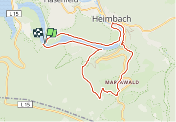
Trail On foot of 9.1 km to be discovered at North Rhine-Westphalia, Kreis Düren, Heimbach. This trail is proposed by SityTrail - itinéraires balisés pédestres.
Description
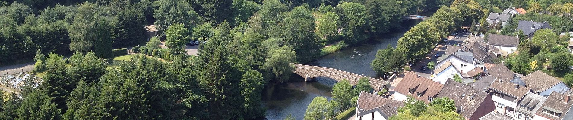
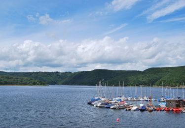
Der Wanderweg führt vom Heimbacher Staubecken hinauf zur Trappisten-Abtei Mariawald. Die Gründung des Klosters geht auf die Wallfahrt zu „Unserer Lieben Frau im Walde“ zurück. Zisterziensermönche errichteten hier 1480 anstelle der Kapelle ein Kloster, dessen Tage allerdings gezählt waren, als die Revolutionsarmee 1794 das linksrheinische Reichsgebiet besetzte. Die Wiederbewirtschaftung der Ländereien und Renovierungsarbeiten begannen erst 1860 mit dem Kauf durch den Trappistenabt Ephrem van der Meulen. Die starken Zerstörungen aus dem 2. Weltkrieg wurden zwischen 1944 und 1961 behoben und der Klosterbetrieb wieder aufgenommen. Heute leben die Mönche einen streng geregelten Tagesablauf. Dem Grundsatz des hl. Benedikt folgend, leben sie von ihrer Hände Arbeit und teilen ihr Brot mit den Gästen und Armen. Gäste sind eingeladen, die klostereigene Gaststätte zu besuchen und die beliebte Erbsensuppe zu probieren. Weitere Bedeutung hat das Kloster für Besucher bekommen, weil es mitten im Nationalpark Eifel liegt.
Website: https://www.rureifel-tourismus.de/wandern/wanderland-rureifel/a-Klosterrunde
Positioning
Comments
Trails nearby
![Trail On foot Heimbach - Meuchelberg - Photo](https://media.geolcdn.com/t/375/260/3837c9cb-359c-4bbd-9282-4a20b946f05d.jpeg&format=jpg&maxdim=2)
![On foot On foot](https://static1.geolcdn.com/sitytour/trail-icons/100.png)
On foot
![](/images/other/stat-length.png)
![](https://static1.geolcdn.com/siteimages/upload/files/16400158638029165_repeat_loop_refresh_sync_direction_icon.png)
![Trail On foot Simmerath - Zur Jungenheck - Photo](https://media.geolcdn.com/t/375/260/be110b12-1459-48ff-ab1e-06f3fa9d3c3d.jpeg&format=jpg&maxdim=2)
![On foot On foot](https://static1.geolcdn.com/sitytour/trail-icons/100.png)
On foot
![](/images/other/stat-length.png)
![](https://static1.geolcdn.com/siteimages/upload/files/16400158638029165_repeat_loop_refresh_sync_direction_icon.png)
![Trail On foot Simmerath - Von Woffelsbach nach Klaus - Photo](https://media.geolcdn.com/t/375/260/64187ad8-77a4-45a1-9a39-2779d6974570.jpeg&format=jpg&maxdim=2)
![On foot On foot](https://static1.geolcdn.com/sitytour/trail-icons/100.png)
On foot
![](/images/other/stat-length.png)
![](https://static1.geolcdn.com/siteimages/upload/files/16400158638029165_repeat_loop_refresh_sync_direction_icon.png)
![Trail On foot Simmerath - Von Woffelsbach über Schmidt nach Schwammenauel - Photo](https://media.geolcdn.com/t/375/260/f7438dae-38ac-4afd-a338-f94a060dbc80.jpeg&format=jpg&maxdim=2)
![On foot On foot](https://static1.geolcdn.com/sitytour/trail-icons/100.png)
On foot
![](/images/other/stat-length.png)
![](https://static1.geolcdn.com/siteimages/upload/files/16400158638029165_repeat_loop_refresh_sync_direction_icon.png)
![Trail On foot Simmerath - Panoramaweg um den Gansberg - Photo](https://media.geolcdn.com/t/375/260/be110b12-1459-48ff-ab1e-06f3fa9d3c3d.jpeg&format=jpg&maxdim=2)
![On foot On foot](https://static1.geolcdn.com/sitytour/trail-icons/100.png)
On foot
![](/images/other/stat-length.png)
![](https://static1.geolcdn.com/siteimages/upload/files/16400158638029165_repeat_loop_refresh_sync_direction_icon.png)
![Trail On foot Simmerath - Schilsbachtal - Photo](https://media.geolcdn.com/t/375/260/64187ad8-77a4-45a1-9a39-2779d6974570.jpeg&format=jpg&maxdim=2)
![On foot On foot](https://static1.geolcdn.com/sitytour/trail-icons/100.png)
On foot
![](/images/other/stat-length.png)
![](https://static1.geolcdn.com/siteimages/upload/files/16400158638029165_repeat_loop_refresh_sync_direction_icon.png)
![Trail On foot Nideggen - Schmidter Runde - Photo](https://media.geolcdn.com/t/375/260/68d8615b-3db1-4004-9cff-4afadf42000f.jpeg&format=jpg&maxdim=2)
![On foot On foot](https://static1.geolcdn.com/sitytour/trail-icons/100.png)
On foot
![](/images/other/stat-length.png)
![](https://static1.geolcdn.com/siteimages/upload/files/16400158638029165_repeat_loop_refresh_sync_direction_icon.png)
![Trail On foot Heimbach - Heimbacher Burgen - Photo](https://media.geolcdn.com/t/375/260/f5795a34-a044-4946-b55a-ed4a5df87132.jpeg&format=jpg&maxdim=2)
![On foot On foot](https://static1.geolcdn.com/sitytour/trail-icons/100.png)
On foot
![](/images/other/stat-length.png)
![](https://static1.geolcdn.com/siteimages/upload/files/16400158638029165_repeat_loop_refresh_sync_direction_icon.png)
![Trail On foot Nideggen - Um den Wildpark Schmidt - Photo](https://media.geolcdn.com/t/375/260/68d8615b-3db1-4004-9cff-4afadf42000f.jpeg&format=jpg&maxdim=2)
![On foot On foot](https://static1.geolcdn.com/sitytour/trail-icons/100.png)
On foot
![](/images/other/stat-length.png)
![](https://static1.geolcdn.com/siteimages/upload/files/16400158638029165_repeat_loop_refresh_sync_direction_icon.png)