Trail On foot Idstein - Rund um Idstein - Photo

Tous les sentiers balisés d’Europe PRO

© OpenStreetMap contributors
Length
Length
33 km
Max alt
Max alt
484 m
Uphill gradient
Uphill gradient
652 m
Km-Effort
Km-Effort  
42 km
Min alt
Min alt
230 m
Downhill gradient
Downhill gradient
791 m
Boucle
Boucle
No
Signpost
Signpost
Creation date :
2022-02-11 13:13:43.164
Updated on :
2022-02-11 13:13:43.164

(0 Reviews)

On foot
On foot
9h34
Difficulty : Very difficult

Scan this QR Code to open this trail in the SityTrail application

FREE GPS app for hiking

Logo SityTrail SityTrail

IGN / Geographical institutes

Download SityTrail from the App Store Download SityTrail from Google Play

Logo SityTrail SityTrail World

The world is yours!

Download SityTrail from the App Store Download SityTrail from Google Play Download SityTrail on Huawei AppGallery

About

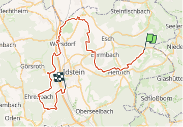
Trail On foot of 33 km to be discovered at Hesse, Rheingau-Taunus-Kreis, Idstein. This trail is proposed by SityTrail - itinéraires balisés pédestres.

Description

Trail created by Idstein Stadtverwaltung.

Symbol: "Stadtwappen: Stilisierte schwarze Burg auf weißen Grund", darunter schwarzer Text "Rund um Idstein"

Photos

Positioning

Country:
Germany
Region :
Hesse
Department/Province :
Rheingau-Taunus-Kreis
Municipality :
Idstein
Location:
Unknown
Start:(UTM)
454776 ; 5565537 (32U) N.

Trails nearby

Trail On foot Idstein - Rundwanderweg Pilz - Photo
On foot
PRO

On foot

Easy
Idstein, Hesse, Rheingau-Taunus-Kreis, Germany
6.4 km | 8.4 km-effort
1h 54min
Yes
Trail On foot Waldems - Rundweg Idstein Lauskippel - Nollen - Photo
On foot
PRO

On foot

Easy
Waldems, Hesse, Rheingau-Taunus-Kreis, Germany
5.6 km | 6.8 km-effort
1h 33min
Yes


Close
My subscriptions