![](/images/other/stat-length.png)
![Trail On foot Kirchenlamitz - Steinbruch Rundwanderweg - Photo](https://media.geolcdn.com/t/1900/400/d28de850-2a90-4926-aedf-30ab04e1934e.jpeg&format=pjpeg&maxdim=2)
Steinbruch Rundwanderweg
SityTrail - itinéraires balisés pédestres
Tous les sentiers balisés d’Europe GUIDE+
![Length](/images/other/stat-length.png)
![Max alt](https://static1.geolcdn.com/siteimages/upload/files/1508320355ic_sort_altitude_max_24dp.png)
![Uphill gradient](https://static1.geolcdn.com/siteimages/upload/files/1508320355ic_sort_den_pos_24dp.png)
![Km-Effort](/images/other/stat-length.png)
![Min alt](https://static1.geolcdn.com/siteimages/upload/files/1508320355ic_sort_altitude_min_24dp.png)
![Downhill gradient](https://static1.geolcdn.com/siteimages/upload/files/1508320355ic_sort_den_neg_24dp.png)
![Boucle](https://static1.geolcdn.com/siteimages/upload/files/16400158638029165_repeat_loop_refresh_sync_direction_icon.png)
![On foot](https://static1.geolcdn.com/sitytour/trail-icons/100.png)
1h11
Difficulty : Easy
![Scan this QR Code to open this trail in the SityTrail application](https://capi.geolives.com/qq0zvz2zws4bq2lad0pu/sitytour/trails/3089547/qr.png?size=200)
FREE GPS app for hiking
About
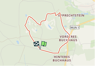
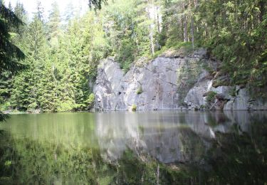
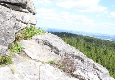
Trail On foot of 3.5 km to be discovered at Bavaria, Landkreis Wunsiedel im Fichtelgebirge, Kirchenlamitz. This trail is proposed by SityTrail - itinéraires balisés pédestres.
Description
Trail created by Stadt Kirchenlamitz.
Symbol: schwarze 4 mit gezackter Linie darunter auf weißem Grund
Website: http://www.kirchenlamitz.de/touristik/kirchenlamitz_umgebung_steinbruchweg.htm
Positioning
Comments
Trails nearby
![Trail On foot Zell im Fichtelgebirge - Sparneck-Großer Waldstein - Photo](https://media.geolcdn.com/t/375/260/87905438-ca66-42aa-999c-81adc2a03c89.jpeg&format=jpg&maxdim=2)
![On foot On foot](https://static1.geolcdn.com/sitytour/trail-icons/100.png)
On foot
![](/images/other/stat-length.png)
![](https://static1.geolcdn.com/siteimages/upload/files/16400158638029165_repeat_loop_refresh_sync_direction_icon.png)
![Trail On foot Kirchenlamitz - Kirchenlamitz - Rundweg](https://media.geolcdn.com/t/375/260/d28de850-2a90-4926-aedf-30ab04e1934e.jpeg&format=jpg&maxdim=2)
![On foot On foot](https://static1.geolcdn.com/sitytour/trail-icons/100.png)
On foot
![](/images/other/stat-length.png)
![](https://static1.geolcdn.com/siteimages/upload/files/16400158638029165_repeat_loop_refresh_sync_direction_icon.png)
![Trail On foot Kirchenlamitz - Rehau - Niederlamitz - Photo](https://media.geolcdn.com/t/375/260/dadb9f78-a2c1-42a0-a020-0335b6593833.jpeg&format=jpg&maxdim=2)
![On foot On foot](https://static1.geolcdn.com/sitytour/trail-icons/100.png)
On foot
![](/images/other/stat-length.png)
![](https://static1.geolcdn.com/siteimages/upload/files/16400158638029165_repeat_loop_refresh_sync_direction_icon.png)
![Trail On foot Weißenstadt - Rundwanderweg Weißenstadt Nr. 3 - Photo](https://media.geolcdn.com/t/375/260/66fba454-a732-40e9-bfd5-d77490a4b796.jpeg&format=jpg&maxdim=2)
![On foot On foot](https://static1.geolcdn.com/sitytour/trail-icons/100.png)
On foot
![](/images/other/stat-length.png)
![](https://static1.geolcdn.com/siteimages/upload/files/16400158638029165_repeat_loop_refresh_sync_direction_icon.png)
![Trail On foot Weißenstadt - Rundwanderweg Weißenstadt Nr. 2 - Photo](https://media.geolcdn.com/t/375/260/dcb7ae84-2017-4e5e-865d-13e6f793cad8.jpeg&format=jpg&maxdim=2)
![On foot On foot](https://static1.geolcdn.com/sitytour/trail-icons/100.png)
On foot
![](/images/other/stat-length.png)
![](https://static1.geolcdn.com/siteimages/upload/files/16400158638029165_repeat_loop_refresh_sync_direction_icon.png)
![Trail On foot Weißenstadt - Rundwanderweg Weißenstadt Nr. 1 - Photo](https://media.geolcdn.com/t/375/260/e68ee7a0-a2bd-4baa-88e4-8c47d09bbc61.jpeg&format=jpg&maxdim=2)
![On foot On foot](https://static1.geolcdn.com/sitytour/trail-icons/100.png)
On foot
![](/images/other/stat-length.png)
![](https://static1.geolcdn.com/siteimages/upload/files/16400158638029165_repeat_loop_refresh_sync_direction_icon.png)
![Trail On foot Kirchenlamitz - DE-2 - Photo](https://media.geolcdn.com/t/375/260/b6c43545-a2da-42ef-88b4-651a62f64955.jpeg&format=jpg&maxdim=2)
![On foot On foot](https://static1.geolcdn.com/sitytour/trail-icons/100.png)
On foot
![](/images/other/stat-length.png)
![](https://static1.geolcdn.com/siteimages/upload/files/16400158638029165_repeat_loop_refresh_sync_direction_icon.png)
![Trail On foot Kirchenlamitz - Epprechtsteinrunde - Photo](https://media.geolcdn.com/t/375/260/b6c43545-a2da-42ef-88b4-651a62f64955.jpeg&format=jpg&maxdim=2)
![On foot On foot](https://static1.geolcdn.com/sitytour/trail-icons/100.png)
On foot
![](/images/other/stat-length.png)
![](https://static1.geolcdn.com/siteimages/upload/files/16400158638029165_repeat_loop_refresh_sync_direction_icon.png)
![Trail On foot Kirchenlamitz - Lamitzquelle - Hirschstein - Photo](https://media.geolcdn.com/t/375/260/8bcf47b4-2ff5-45f0-b1a7-b471ec958352.jpeg&format=jpg&maxdim=2)
![On foot On foot](https://static1.geolcdn.com/sitytour/trail-icons/100.png)
On foot
![](/images/other/stat-length.png)
![](https://static1.geolcdn.com/siteimages/upload/files/16400158638029165_repeat_loop_refresh_sync_direction_icon.png)