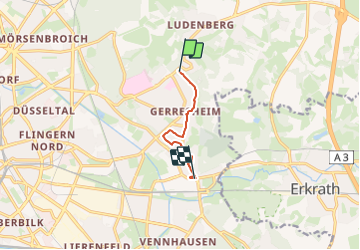
![](/images/other/stat-length.png)
![Trail On foot Unknown - Industriepfad Düsseldorf-Gerresheim - Photo](https://media.geolcdn.com/t/1900/400/d0cb714a-becf-4430-8992-a4b859ea4a1c.jpeg&format=pjpeg&maxdim=2)
Industriepfad Düsseldorf-Gerresheim
SityTrail - itinéraires balisés pédestres
Tous les sentiers balisés d’Europe GUIDE+
![Length](/images/other/stat-length.png)
![Max alt](https://static1.geolcdn.com/siteimages/upload/files/1508320355ic_sort_altitude_max_24dp.png)
![Uphill gradient](https://static1.geolcdn.com/siteimages/upload/files/1508320355ic_sort_den_pos_24dp.png)
![Km-Effort](/images/other/stat-length.png)
![Min alt](https://static1.geolcdn.com/siteimages/upload/files/1508320355ic_sort_altitude_min_24dp.png)
![Downhill gradient](https://static1.geolcdn.com/siteimages/upload/files/1508320355ic_sort_den_neg_24dp.png)
![Boucle](https://static1.geolcdn.com/siteimages/upload/files/16400158638029165_repeat_loop_refresh_sync_direction_icon.png)
![On foot](https://static1.geolcdn.com/sitytour/trail-icons/100.png)
1h06
Difficulty : Easy
![Scan this QR Code to open this trail in the SityTrail application](https://capi.geolives.com/qq0zvz2zws4bq2lad0pu/sitytour/trails/3089405/qr.png?size=200)
FREE GPS app for hiking
About
Trail On foot of 4.5 km to be discovered at North Rhine-Westphalia, Dusseldorf, Unknown. This trail is proposed by SityTrail - itinéraires balisés pédestres.
Description
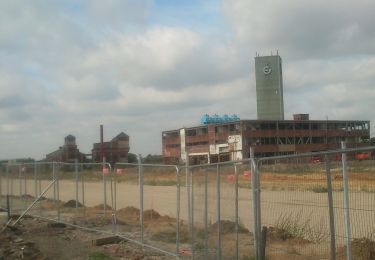
Trail created by Förderkreis Industriepfad Düsseldorf-Gerresheim e.V..
Der Industriepfad kann beim Ringofen noch nicht in seiner endgültigen Führung eingegeben werden, da noch Wege im Neubaugebiet fehlen. Weithin fehlen noch die meisten Informationsstelen.
Positioning
Comments
Trails nearby
![Trail On foot Erkrath - Neanderlandsteig Entdeckerschleife](https://media.geolcdn.com/t/375/260/f0a4c676-b45d-44ca-9d2f-c9554313404f.jpeg&format=jpg&maxdim=2)
![On foot On foot](https://static1.geolcdn.com/sitytour/trail-icons/100.png)
On foot
![](/images/other/stat-length.png)
![](https://static1.geolcdn.com/siteimages/upload/files/16400158638029165_repeat_loop_refresh_sync_direction_icon.png)
![Trail On foot Unknown - Aaperwald Rundweg A2 - Photo](https://media.geolcdn.com/t/375/260/ca0b790a-7d1f-4d5e-b73b-8c860418e106.jpeg&format=jpg&maxdim=2)
![On foot On foot](https://static1.geolcdn.com/sitytour/trail-icons/100.png)
On foot
![](/images/other/stat-length.png)
![](https://static1.geolcdn.com/siteimages/upload/files/16400158638029165_repeat_loop_refresh_sync_direction_icon.png)
![Trail On foot Unknown - Rechteck Gerresheim-Unterbach - Photo](https://media.geolcdn.com/t/375/260/533e878e-0bfb-411b-a976-bd0edf99eb3a.jpeg&format=jpg&maxdim=2)
![On foot On foot](https://static1.geolcdn.com/sitytour/trail-icons/100.png)
On foot
![](/images/other/stat-length.png)
![](https://static1.geolcdn.com/siteimages/upload/files/16400158638029165_repeat_loop_refresh_sync_direction_icon.png)
![Trail On foot Erkrath - Rechteck Erkrath-Eller - Photo](https://media.geolcdn.com/t/375/260/869ed9d6-13d5-459e-9f12-6811fc83e378.jpeg&format=jpg&maxdim=2)
![On foot On foot](https://static1.geolcdn.com/sitytour/trail-icons/100.png)
On foot
![](/images/other/stat-length.png)
![](https://static1.geolcdn.com/siteimages/upload/files/16400158638029165_repeat_loop_refresh_sync_direction_icon.png)
![Trail On foot Erkrath - Doppelbalken Rund um Alt-Erkrath - Photo](https://media.geolcdn.com/t/375/260/fa6b4399-24c9-49f3-9a97-8e33e8c2dfbf.jpeg&format=jpg&maxdim=2)
![On foot On foot](https://static1.geolcdn.com/sitytour/trail-icons/100.png)
On foot
![](/images/other/stat-length.png)
![](https://static1.geolcdn.com/siteimages/upload/files/16400158638029165_repeat_loop_refresh_sync_direction_icon.png)
![Trail On foot Unknown - Aaperwald Rundweg A1 - Photo](https://media.geolcdn.com/t/375/260/4d07ddde-f9f0-4046-a6db-7f628bc2b8e3.jpeg&format=jpg&maxdim=2)
![On foot On foot](https://static1.geolcdn.com/sitytour/trail-icons/100.png)
On foot
![](/images/other/stat-length.png)
![](https://static1.geolcdn.com/siteimages/upload/files/16400158638029165_repeat_loop_refresh_sync_direction_icon.png)
![Trail On foot Unknown - Aaperwald Rundweg A4 - Photo](https://media.geolcdn.com/t/375/260/cc10fb3b-0b55-4811-9c85-f69bb325738c.jpeg&format=jpg&maxdim=2)
![On foot On foot](https://static1.geolcdn.com/sitytour/trail-icons/100.png)
On foot
![](/images/other/stat-length.png)
![](https://static1.geolcdn.com/siteimages/upload/files/16400158638029165_repeat_loop_refresh_sync_direction_icon.png)
![Trail On foot Unknown - [D] Düsseldorfer Weg - Photo](https://media.geolcdn.com/t/375/260/02398625-9783-4a6b-913e-ce79bc76d8b1.jpeg&format=jpg&maxdim=2)
![On foot On foot](https://static1.geolcdn.com/sitytour/trail-icons/100.png)
On foot
![](/images/other/stat-length.png)
![](https://static1.geolcdn.com/siteimages/upload/files/16400158638029165_repeat_loop_refresh_sync_direction_icon.png)
![Trail On foot Erkrath - Vollquadrat Gerresheim-Neanderthal - Photo](https://media.geolcdn.com/t/375/260/d1572fd1-0357-4966-88ad-318e5641457b.jpeg&format=jpg&maxdim=2)
![On foot On foot](https://static1.geolcdn.com/sitytour/trail-icons/100.png)
On foot
![](/images/other/stat-length.png)
![](https://static1.geolcdn.com/siteimages/upload/files/16400158638029165_repeat_loop_refresh_sync_direction_icon.png)