![](/images/other/stat-length.png)
![Trail On foot Unknown - DAK-Eisert-Nordic Walking Parcour - Photo](https://media.geolcdn.com/t/1900/400/83bb39d6-d712-4c37-9cdf-22ccc440f885.jpeg&format=pjpeg&maxdim=2)
DAK-Eisert-Nordic Walking Parcour
SityTrail - itinéraires balisés pédestres
Tous les sentiers balisés d’Europe GUIDE+
![Length](/images/other/stat-length.png)
![Max alt](https://static1.geolcdn.com/siteimages/upload/files/1508320355ic_sort_altitude_max_24dp.png)
![Uphill gradient](https://static1.geolcdn.com/siteimages/upload/files/1508320355ic_sort_den_pos_24dp.png)
![Km-Effort](/images/other/stat-length.png)
![Min alt](https://static1.geolcdn.com/siteimages/upload/files/1508320355ic_sort_altitude_min_24dp.png)
![Downhill gradient](https://static1.geolcdn.com/siteimages/upload/files/1508320355ic_sort_den_neg_24dp.png)
![Boucle](https://static1.geolcdn.com/siteimages/upload/files/16400158638029165_repeat_loop_refresh_sync_direction_icon.png)
![On foot](https://static1.geolcdn.com/sitytour/trail-icons/100.png)
3h12
Difficulty : Easy
![Scan this QR Code to open this trail in the SityTrail application](https://capi.geolives.com/qq0zvz2zws4bq2lad0pu/sitytour/trails/3089299/qr.png?size=200)
FREE GPS app for hiking
About
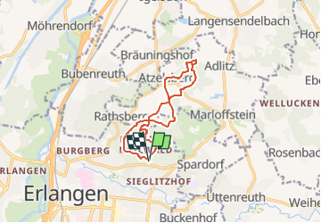
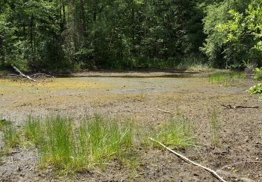
Trail On foot of 10.9 km to be discovered at Bavaria, Erlangen. This trail is proposed by SityTrail - itinéraires balisés pédestres.
Description
Trail created by DAK.
wieder zurück geändert, da von der Stadt kurz falsch markiert von kanu_guenni 03/15, modifiziert, da er sich geändert hat im März´11 / komplett abgelaufen mit GPS kanu_guenni 2010, geprüft (Feb. 2012 by cycling_zno)
Symbol: roter Punkt auf größeren blauen Kreis
Positioning
Comments
Trails nearby
![Trail On foot - Erlangen-Steudach - Photo](https://media.geolcdn.com/t/375/260/326b0b59-d310-4208-b907-9fdb0ba2140b.jpeg&format=jpg&maxdim=2)
![On foot On foot](https://static1.geolcdn.com/sitytour/trail-icons/100.png)
![Trail On foot Bubenreuth - Hochwasserweg - Photo](https://media.geolcdn.com/t/375/260/0d4ced9c-0240-4646-a9bb-3ad2a492dab7.jpeg&format=jpg&maxdim=2)
![On foot On foot](https://static1.geolcdn.com/sitytour/trail-icons/100.png)
On foot
![](/images/other/stat-length.png)
![](https://static1.geolcdn.com/siteimages/upload/files/16400158638029165_repeat_loop_refresh_sync_direction_icon.png)
![Trail On foot Marloffstein - Berg & Talpfad - Photo](https://media.geolcdn.com/t/375/260/0d4ced9c-0240-4646-a9bb-3ad2a492dab7.jpeg&format=jpg&maxdim=2)
![On foot On foot](https://static1.geolcdn.com/sitytour/trail-icons/100.png)
On foot
![](/images/other/stat-length.png)
![](https://static1.geolcdn.com/siteimages/upload/files/16400158638029165_repeat_loop_refresh_sync_direction_icon.png)
![Trail On foot Buckenhofer Forst - Kreuzeiche Trail - Photo](https://media.geolcdn.com/t/375/260/b4b6bb74-7819-4b5c-9ec1-7ba33dbaf327.jpeg&format=jpg&maxdim=2)
![On foot On foot](https://static1.geolcdn.com/sitytour/trail-icons/100.png)
On foot
![](/images/other/stat-length.png)
![](https://static1.geolcdn.com/siteimages/upload/files/16400158638029165_repeat_loop_refresh_sync_direction_icon.png)
![Trail On foot Buckenhofer Forst - Hirschlecke Trail - Photo](https://media.geolcdn.com/t/375/260/b4b6bb74-7819-4b5c-9ec1-7ba33dbaf327.jpeg&format=jpg&maxdim=2)
![On foot On foot](https://static1.geolcdn.com/sitytour/trail-icons/100.png)
On foot
![](/images/other/stat-length.png)
![](https://static1.geolcdn.com/siteimages/upload/files/16400158638029165_repeat_loop_refresh_sync_direction_icon.png)
![Trail On foot - Zigeunereck Trail - Photo](https://media.geolcdn.com/t/375/260/2d289e07-5fb0-4f85-a06b-129887d0ae8b.jpeg&format=jpg&maxdim=2)
![On foot On foot](https://static1.geolcdn.com/sitytour/trail-icons/100.png)
![Trail On foot Möhrendorf - Wanderweg Südlicher Möhrendorfer Rundweg - Photo](https://media.geolcdn.com/t/375/260/ea22ba3f-a9ef-4aa3-9503-4a65b8526407.jpeg&format=jpg&maxdim=2)
![On foot On foot](https://static1.geolcdn.com/sitytour/trail-icons/100.png)
On foot
![](/images/other/stat-length.png)
![](https://static1.geolcdn.com/siteimages/upload/files/16400158638029165_repeat_loop_refresh_sync_direction_icon.png)
![Trail On foot Möhrendorf - Wanderweg Nördlicher Möhrendorfer Rundweg - Photo](https://media.geolcdn.com/t/375/260/e180760a-0888-4e24-92e4-d287ef34491e.jpeg&format=jpg&maxdim=2)
![On foot On foot](https://static1.geolcdn.com/sitytour/trail-icons/100.png)
On foot
![](/images/other/stat-length.png)
![](https://static1.geolcdn.com/siteimages/upload/files/16400158638029165_repeat_loop_refresh_sync_direction_icon.png)
![Trail On foot Möhrendorf - Naturerlebnispfad Erlangen - Photo](https://media.geolcdn.com/t/375/260/ea22ba3f-a9ef-4aa3-9503-4a65b8526407.jpeg&format=jpg&maxdim=2)
![On foot On foot](https://static1.geolcdn.com/sitytour/trail-icons/100.png)
On foot
![](/images/other/stat-length.png)
![](https://static1.geolcdn.com/siteimages/upload/files/16400158638029165_repeat_loop_refresh_sync_direction_icon.png)