![](/images/other/stat-length.png)
![Trail On foot Sailauf - Kulturweg Sailauf - Photo](https://media.geolcdn.com/t/1900/400/3b4180a7-f46f-4b77-b2b9-02a312ced416.jpeg&format=pjpeg&maxdim=2)
Kulturweg Sailauf
SityTrail - itinéraires balisés pédestres
Tous les sentiers balisés d’Europe GUIDE+
![Length](/images/other/stat-length.png)
![Max alt](https://static1.geolcdn.com/siteimages/upload/files/1508320355ic_sort_altitude_max_24dp.png)
![Uphill gradient](https://static1.geolcdn.com/siteimages/upload/files/1508320355ic_sort_den_pos_24dp.png)
![Km-Effort](/images/other/stat-length.png)
![Min alt](https://static1.geolcdn.com/siteimages/upload/files/1508320355ic_sort_altitude_min_24dp.png)
![Downhill gradient](https://static1.geolcdn.com/siteimages/upload/files/1508320355ic_sort_den_neg_24dp.png)
![Boucle](https://static1.geolcdn.com/siteimages/upload/files/16400158638029165_repeat_loop_refresh_sync_direction_icon.png)
![On foot](https://static1.geolcdn.com/sitytour/trail-icons/100.png)
3h03
Difficulty : Easy
![Scan this QR Code to open this trail in the SityTrail application](https://capi.geolives.com/qq0zvz2zws4bq2lad0pu/sitytour/trails/3089063/qr.png?size=200)
FREE GPS app for hiking
About
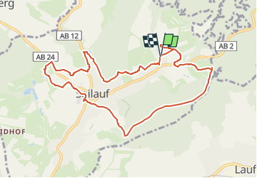
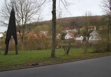
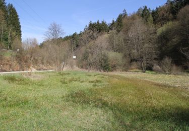
Trail On foot of 9.9 km to be discovered at Bavaria, Landkreis Aschaffenburg, Sailauf. This trail is proposed by SityTrail - itinéraires balisés pédestres.
Description
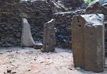
Trail created by Archäologisches Spessartprojekt.
Symbol: Gelbes EU-Schiffchen auf blauem Grund
Website: http://www.spessartprojekt.de/kulturwege/sailauf/index.php
Positioning
Comments
Trails nearby
![Trail On foot Laufach - Frohnhofen Rundwanderweg F1 - Photo](https://media.geolcdn.com/t/375/260/fdff1b94-80a0-4e7f-98b6-b15761402970.jpeg&format=jpg&maxdim=2)
![On foot On foot](https://static1.geolcdn.com/sitytour/trail-icons/100.png)
On foot
![](/images/other/stat-length.png)
![](https://static1.geolcdn.com/siteimages/upload/files/16400158638029165_repeat_loop_refresh_sync_direction_icon.png)
![Trail On foot Hösbach - Sailauf Rundwanderweg 7 - Photo](https://media.geolcdn.com/t/375/260/7d643654-5923-4218-b7aa-24f4197b650b.jpeg&format=jpg&maxdim=2)
![On foot On foot](https://static1.geolcdn.com/sitytour/trail-icons/100.png)
On foot
![](/images/other/stat-length.png)
![](https://static1.geolcdn.com/siteimages/upload/files/16400158638029165_repeat_loop_refresh_sync_direction_icon.png)
![Trail On foot Sommerkahl - Naturlehrpfad](https://media.geolcdn.com/t/375/260/37a2dfee-d4f9-44ca-8782-d6ff34d3e978.jpeg&format=jpg&maxdim=2)
![On foot On foot](https://static1.geolcdn.com/sitytour/trail-icons/100.png)
On foot
![](/images/other/stat-length.png)
![](https://static1.geolcdn.com/siteimages/upload/files/16400158638029165_repeat_loop_refresh_sync_direction_icon.png)
![Trail On foot Schöllkrippener Forst - Schwarzer Fuchs, Rundwanderweg Sommerkahl - Photo](https://media.geolcdn.com/t/375/260/af6651aa-cb9c-4026-91fa-1c7ae45dbe30.jpeg&format=jpg&maxdim=2)
![On foot On foot](https://static1.geolcdn.com/sitytour/trail-icons/100.png)
On foot
![](/images/other/stat-length.png)
![](https://static1.geolcdn.com/siteimages/upload/files/16400158638029165_repeat_loop_refresh_sync_direction_icon.png)
![Trail On foot Sommerkahl - Ortswanderweg Sommerkahl 1 - Photo](https://media.geolcdn.com/t/375/260/ec6e35bf-11c3-4823-9534-4bfc333816b5.jpeg&format=jpg&maxdim=2)
![On foot On foot](https://static1.geolcdn.com/sitytour/trail-icons/100.png)
On foot
![](/images/other/stat-length.png)
![](https://static1.geolcdn.com/siteimages/upload/files/16400158638029165_repeat_loop_refresh_sync_direction_icon.png)
![Trail On foot Laufach - Roter Hase, Rundwanderweg Laufach - Photo](https://media.geolcdn.com/t/375/260/30c9fbb3-aad6-4e1a-897f-e1470992e5f2.jpeg&format=jpg&maxdim=2)
![On foot On foot](https://static1.geolcdn.com/sitytour/trail-icons/100.png)
On foot
![](/images/other/stat-length.png)
![](https://static1.geolcdn.com/siteimages/upload/files/16400158638029165_repeat_loop_refresh_sync_direction_icon.png)
![Trail On foot Heigenbrücken - Roter Schmetterling, Rundwanderweg Sailauf - Photo](https://media.geolcdn.com/t/375/260/98e10225-4b92-4819-9887-ee487c0aaf52.jpeg&format=jpg&maxdim=2)
![On foot On foot](https://static1.geolcdn.com/sitytour/trail-icons/100.png)
On foot
![](/images/other/stat-length.png)
![](https://static1.geolcdn.com/siteimages/upload/files/16400158638029165_repeat_loop_refresh_sync_direction_icon.png)
![Trail On foot Sailaufer Forst - Schwarzer Fuchs, Rundwanderweg Heigenbrücken - Jakobsthal - Photo](https://media.geolcdn.com/t/375/260/74fa9d99-e3f0-4894-afb1-54cfc1a09313.jpeg&format=jpg&maxdim=2)
![On foot On foot](https://static1.geolcdn.com/sitytour/trail-icons/100.png)
On foot
![](/images/other/stat-length.png)
![](https://static1.geolcdn.com/siteimages/upload/files/16400158638029165_repeat_loop_refresh_sync_direction_icon.png)
![Trail On foot Laufach - Laufach Rundwanderweg L3 - Photo](https://media.geolcdn.com/t/375/260/511addfa-c33b-4853-aa96-c6ced777fb23.jpeg&format=jpg&maxdim=2)
![On foot On foot](https://static1.geolcdn.com/sitytour/trail-icons/100.png)
On foot
![](/images/other/stat-length.png)
![](https://static1.geolcdn.com/siteimages/upload/files/16400158638029165_repeat_loop_refresh_sync_direction_icon.png)