


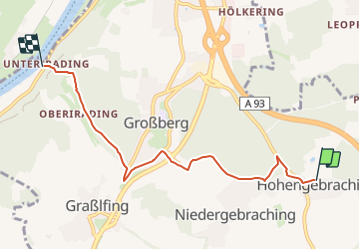

6.3 km | 6.8 km-effort
![Trail On foot Pentling - S 20 Hohengebraching - Unterirading [Walba] (Blaues Rechteck) - Photo](https://media.geolcdn.com/t/1900/400/ext.pjpeg?maxdim=2&url=https%3A%2F%2Fmedia.geolcdn.com%2Ff%2F81f267c5-b53b-4c4e-b86a-f20025f30912.jpeg)

Tous les sentiers balisés d’Europe GUIDE+


FREE GPS app for hiking
 SityTrail
IGN / Geographical institutes
SityTrail World
The world is yours!
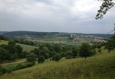
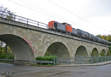
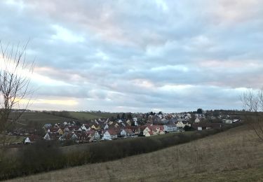
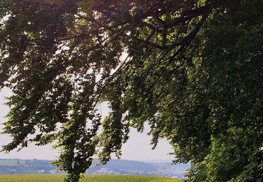
Trail On foot of 5.3 km to be discovered at Bavaria, Landkreis Regensburg, Pentling. This trail is proposed by SityTrail - itinéraires balisés pédestres.
Trail created by Waldverein Regensburg.
FIXME: Nicht alle Segmente erfaßt.
Symbol: Blaues Rechteck auf weißem Grund
![Trail On foot Pentling - S 20 Hohengebraching - Unterirading [Walba] (Blaues Rechteck) - Photo 1](https://media.geolcdn.com/t/2048/auto/2a9617a2-ffac-4119-9c97-546b181fa77c.jpeg&format=jpg&maxdim=0 "Trail On foot Pentling - S 20 Hohengebraching - Unterirading [Walba] (Blaues Rechteck) - Photo 1")
![Trail On foot Pentling - S 20 Hohengebraching - Unterirading [Walba] (Blaues Rechteck) - Photo 2](https://media.geolcdn.com/t/2048/auto/81f267c5-b53b-4c4e-b86a-f20025f30912.jpeg&format=jpg&maxdim=0 "Trail On foot Pentling - S 20 Hohengebraching - Unterirading [Walba] (Blaues Rechteck) - Photo 2")
![Trail On foot Pentling - S 20 Hohengebraching - Unterirading [Walba] (Blaues Rechteck) - Photo 3](https://media.geolcdn.com/t/2048/auto/7d6fa5d6-9ee6-489a-97f6-5a34cf9f4e76.jpeg&format=jpg&maxdim=0 "Trail On foot Pentling - S 20 Hohengebraching - Unterirading [Walba] (Blaues Rechteck) - Photo 3")
![Trail On foot Pentling - S 20 Hohengebraching - Unterirading [Walba] (Blaues Rechteck) - Photo 4](https://media.geolcdn.com/t/2048/auto/032bf50e-1c98-49f8-9882-89406615f80a.jpeg&format=jpg&maxdim=0 "Trail On foot Pentling - S 20 Hohengebraching - Unterirading [Walba] (Blaues Rechteck) - Photo 4")
![Trail On foot Pentling - S 20 Hohengebraching - Unterirading [Walba] (Blaues Rechteck) - Photo 5](https://media.geolcdn.com/t/2048/auto/db47d515-938d-4481-805f-5b9d5d6732f8.jpeg&format=jpg&maxdim=0 "Trail On foot Pentling - S 20 Hohengebraching - Unterirading [Walba] (Blaues Rechteck) - Photo 5")
![Trail On foot Pentling - S 20 Hohengebraching - Unterirading [Walba] (Blaues Rechteck) - Photo 6](https://media.geolcdn.com/t/2048/auto/a23ae219-9f13-4d75-bc5e-64f6478a612e.jpeg&format=jpg&maxdim=0 "Trail On foot Pentling - S 20 Hohengebraching - Unterirading [Walba] (Blaues Rechteck) - Photo 6")
![Trail On foot Pentling - S 20 Hohengebraching - Unterirading [Walba] (Blaues Rechteck) - Photo 7](https://media.geolcdn.com/t/2048/auto/f78eb584-6bbe-4db9-bfb9-886fd22c722c.jpeg&format=jpg&maxdim=0 "Trail On foot Pentling - S 20 Hohengebraching - Unterirading [Walba] (Blaues Rechteck) - Photo 7")
![Trail On foot Pentling - S 20 Hohengebraching - Unterirading [Walba] (Blaues Rechteck) - Photo 8](https://media.geolcdn.com/t/2048/auto/f96c3f4e-7e8e-4f92-92a0-5d0e54004354.jpeg&format=jpg&maxdim=0 "Trail On foot Pentling - S 20 Hohengebraching - Unterirading [Walba] (Blaues Rechteck) - Photo 8")
![Trail On foot Pentling - S 20 Hohengebraching - Unterirading [Walba] (Blaues Rechteck) - Photo 9](https://media.geolcdn.com/t/2048/auto/f9bc485c-1d4e-400a-8ed0-bddcfaf40250.jpeg&format=jpg&maxdim=0 "Trail On foot Pentling - S 20 Hohengebraching - Unterirading [Walba] (Blaues Rechteck) - Photo 9")
![Trail On foot Pentling - S 20 Hohengebraching - Unterirading [Walba] (Blaues Rechteck) - Photo 10](https://media.geolcdn.com/t/2048/auto/5aa716e9-58bf-467b-a9c5-2cdd00bad641.jpeg&format=jpg&maxdim=0 "Trail On foot Pentling - S 20 Hohengebraching - Unterirading [Walba] (Blaues Rechteck) - Photo 10")
On foot
On foot
On foot
On foot
On foot
On foot
On foot
![Trail On foot - S 21 Regensburg-Neuprüll - Unterirading [Walba] (Grünes Rechteck) - Photo](https://media.geolcdn.com/t/375/260/ext.jpg?maxdim=2&url=https%3A%2F%2Fmedia.geolcdn.com%2Ff%2Ff7ecf863-2b2d-4886-b112-06f87ea34e11.jpeg)
On foot
On foot