


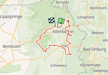

14.6 km | 19.1 km-effort
![Trail On foot Altenbeken - Viadukt-Wanderweg [Altenbeken] - Photo](https://media.geolcdn.com/t/1900/400/c27d496e-1353-4f5d-a83c-56dcc01609ed.jpeg&format=pjpeg&maxdim=2)

Tous les sentiers balisés d’Europe GUIDE+


FREE GPS app for hiking
 SityTrail
IGN / Geographical institutes
SityTrail World
The world is yours!
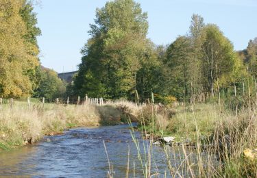
Trail On foot of 27 km to be discovered at North Rhine-Westphalia, Kreis Paderborn, Altenbeken. This trail is proposed by SityTrail - itinéraires balisés pédestres.
Trail created by Gemeinde Altenbeken.
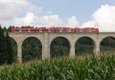
Symbol: Text "Viadukt-Wanderweg" auf blauem Grund, unter Symbolgrafik des Altenbekener Viaduktes
![Trail On foot Altenbeken - Viadukt-Wanderweg [Altenbeken] - Photo 1](https://media.geolcdn.com/t/2048/auto/0d16f001-b35b-4172-b0d7-91dd2e576713.jpeg&format=jpg&maxdim=0 "Trail On foot Altenbeken - Viadukt-Wanderweg [Altenbeken] - Photo 1")
![Trail On foot Altenbeken - Viadukt-Wanderweg [Altenbeken] - Photo 2](https://media.geolcdn.com/t/2048/auto/c9d80abe-57ba-479a-94d0-0401ad5904a9.jpeg&format=jpg&maxdim=0 "Trail On foot Altenbeken - Viadukt-Wanderweg [Altenbeken] - Photo 2")
![Trail On foot Altenbeken - Viadukt-Wanderweg [Altenbeken] - Photo 3](https://media.geolcdn.com/t/2048/auto/8746eb85-e8ec-4ac1-8372-36bd8f11f72f.jpeg&format=jpg&maxdim=0 "Trail On foot Altenbeken - Viadukt-Wanderweg [Altenbeken] - Photo 3")
![Trail On foot Altenbeken - Viadukt-Wanderweg [Altenbeken] - Photo 4](https://media.geolcdn.com/t/2048/auto/b5633eff-b386-493a-bed5-8f3cef51c6a7.jpeg&format=jpg&maxdim=0 "Trail On foot Altenbeken - Viadukt-Wanderweg [Altenbeken] - Photo 4")
![Trail On foot Altenbeken - Viadukt-Wanderweg [Altenbeken] - Photo 5](https://media.geolcdn.com/t/2048/auto/33224230-9e00-46b7-87ff-a9b214dd60ea.jpeg&format=jpg&maxdim=0 "Trail On foot Altenbeken - Viadukt-Wanderweg [Altenbeken] - Photo 5")
![Trail On foot Altenbeken - Viadukt-Wanderweg [Altenbeken] - Photo 6](https://media.geolcdn.com/t/2048/auto/b3bebafc-8cd4-4ae0-b248-80299abeba08.jpeg&format=jpg&maxdim=0 "Trail On foot Altenbeken - Viadukt-Wanderweg [Altenbeken] - Photo 6")
![Trail On foot Altenbeken - Viadukt-Wanderweg [Altenbeken] - Photo 7](https://media.geolcdn.com/t/2048/auto/2ceda9e1-4a12-4342-aab8-848c5471f969.jpeg&format=jpg&maxdim=0 "Trail On foot Altenbeken - Viadukt-Wanderweg [Altenbeken] - Photo 7")
![Trail On foot Altenbeken - Viadukt-Wanderweg [Altenbeken] - Photo 8](https://media.geolcdn.com/t/2048/auto/9409f9f8-07ff-4e22-abca-fd8bea912406.jpeg&format=jpg&maxdim=0 "Trail On foot Altenbeken - Viadukt-Wanderweg [Altenbeken] - Photo 8")
![Trail On foot Altenbeken - Viadukt-Wanderweg [Altenbeken] - Photo 9](https://media.geolcdn.com/t/2048/auto/c27d496e-1353-4f5d-a83c-56dcc01609ed.jpeg&format=jpg&maxdim=0 "Trail On foot Altenbeken - Viadukt-Wanderweg [Altenbeken] - Photo 9")
![Trail On foot Altenbeken - Viadukt-Wanderweg [Altenbeken] - Photo 10](https://media.geolcdn.com/t/2048/auto/50129e14-30cc-4eb8-bd5d-31097c479126.jpeg&format=jpg&maxdim=0 "Trail On foot Altenbeken - Viadukt-Wanderweg [Altenbeken] - Photo 10")
On foot
On foot
On foot
On foot
On foot
On foot
On foot
On foot
![Trail On foot Steinheim - Rundwanderweg A1 [Grevenhagen] - Photo](https://media.geolcdn.com/t/375/260/202ac17e-dbff-44d1-b3d9-93eb341f466c.jpeg&format=jpg&maxdim=2)
On foot