Trail On foot Unknown - Luchspfad - Photo

Tous les sentiers balisés d’Europe GUIDE+

© OpenStreetMap contributors
Length
Length
4 km
Max alt
Max alt
781 m
Uphill gradient
Uphill gradient
85 m
Km-Effort
Km-Effort  
5 km
Min alt
Min alt
725 m
Downhill gradient
Downhill gradient
65 m
Boucle
Boucle
No
Signpost
Signpost
Creation date :
2022-02-11 12:56:08.148
Updated on :
2022-02-11 12:56:08.148

(0 Reviews)

On foot
On foot
1h08
Difficulty : Easy

Scan this QR Code to open this trail in the SityTrail application

FREE GPS app for hiking

Logo SityTrail SityTrail

IGN / Geographical institutes

Download SityTrail from the App Store Download SityTrail from Google Play

Logo SityTrail SityTrail World

The world is yours!

Download SityTrail from the App Store Download SityTrail from Google Play Download SityTrail on Huawei AppGallery

About

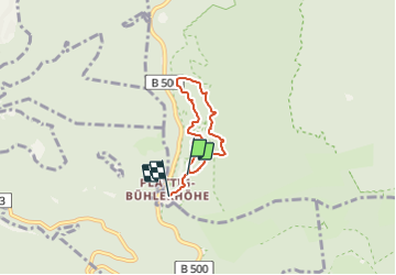
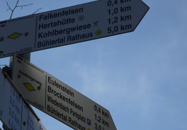
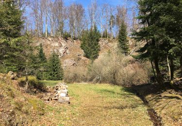
Trail On foot of 4 km to be discovered at Baden-Württemberg, Baden-Baden. This trail is proposed by SityTrail - itinéraires balisés pédestres.

Description

symbol approaches atual symbol as good as possible

Symbol: White lynx siluhette on a background in a green circle

Elevation profile

Photos

Positioning

Country:
Germany
Region :
Baden-Württemberg
Department/Province :
Baden-Baden
Municipality :
Unknown
Location:
Unknown
Start:(UTM)
443766 ; 5391255 (32U) N.

Trails nearby

Trail On foot  - Am Froschbach - Am Urbach - Photo
On foot
GUIDE+

On foot

Easy
, Baden-Württemberg, Baden-Baden, Germany
3.9 km | 4.5 km-effort
1h 1min
No
Trail On foot  - Zimmerplatz - Bildeiche - Photo
On foot
GUIDE+

On foot

Easy
, Baden-Württemberg, Baden-Baden, Germany
3.1 km | 4.8 km-effort
1h 5min
No
Trail On foot Bühl - Gertelbach-Rundweg - Photo
On foot
GUIDE+

On foot

Easy
Bühl, Baden-Württemberg, Landkreis Rastatt, Germany
8.9 km | 14.6 km-effort
3h 19min
Yes
Trail On foot Forbach - Winterwanderweg rote Lache 1 - Photo
On foot
GUIDE+

On foot

Easy
Forbach, Baden-Württemberg, Landkreis Rastatt, Germany
4.9 km | 7.3 km-effort
1h 39min
Yes
Trail On foot  - Wildnispfad - Photo
On foot
GUIDE+

On foot

Easy
, Baden-Württemberg, Baden-Baden, Germany
3.4 km | 4.4 km-effort
1h 0min
Yes
Trail On foot  - Steinberg Rundweg - Photo
On foot
GUIDE+

On foot

Easy
, Baden-Württemberg, Baden-Baden, Germany
3.8 km | 4.6 km-effort
1h 3min
Yes
Trail On foot  - Scherrhof - Am Ruberg - Photo
On foot
GUIDE+

On foot

Easy
, Baden-Württemberg, Baden-Baden, Germany
3.2 km | 4.1 km-effort
55min
No
Trail Walking Bühlertal - Gertelbach-Rundweg - Photo
Walking
Delouis

Walking

Medium
Bühlertal, Baden-Württemberg, Landkreis Rastatt, Germany
9.5 km | 15.4 km-effort
3h 30min
Yes
Trail Other activity Bühlertal - Gertelbach Wasserfälle Rundweg - Photo
Other activity
reymuben

Other activity

Very easy
Bühlertal, Baden-Württemberg, Landkreis Rastatt, Germany
9.5 km | 15.5 km-effort
Unknown
Yes


Close
My subscriptions