![](/images/other/stat-length.png)
![Trail On foot Oberlahr - Erz-Wanderweg - Photo](https://media.geolcdn.com/t/1900/400/a78ff331-d0a8-4572-9aef-a5191292008d.jpeg&format=pjpeg&maxdim=2)
Erz-Wanderweg
SityTrail - itinéraires balisés pédestres
Tous les sentiers balisés d’Europe GUIDE+
![Length](/images/other/stat-length.png)
Length
6.2 km
![Max alt](https://static1.geolcdn.com/siteimages/upload/files/1508320355ic_sort_altitude_max_24dp.png)
Max alt
310 m
![Uphill gradient](https://static1.geolcdn.com/siteimages/upload/files/1508320355ic_sort_den_pos_24dp.png)
Uphill gradient
185 m
![Km-Effort](/images/other/stat-length.png)
Km-Effort
8.4 km
![Min alt](https://static1.geolcdn.com/siteimages/upload/files/1508320355ic_sort_altitude_min_24dp.png)
Min alt
171 m
![Downhill gradient](https://static1.geolcdn.com/siteimages/upload/files/1508320355ic_sort_den_neg_24dp.png)
Downhill gradient
121 m
![Boucle](https://static1.geolcdn.com/siteimages/upload/files/16400158638029165_repeat_loop_refresh_sync_direction_icon.png)
Boucle
No
Signpost
Creation date :
2022-02-11 12:54:19.699
Updated on :
2022-02-11 12:54:19.699
![On foot](https://static1.geolcdn.com/sitytour/trail-icons/100.png)
1h55
Difficulty : Easy
![Scan this QR Code to open this trail in the SityTrail application](https://capi.geolives.com/qq0zvz2zws4bq2lad0pu/sitytour/trails/3088458/qr.png?size=200)
FREE GPS app for hiking
About
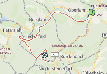
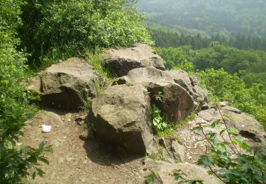
Trail On foot of 6.2 km to be discovered at Rhineland-Palatinate, Landkreis Altenkirchen, Oberlahr. This trail is proposed by SityTrail - itinéraires balisés pédestres.
Description
Trail created by Förderverein Bergbau- und Hüttentradition VG Flammersfeld.
Symbol: Rotes "Schlägel und Eisen"
Positioning
Country:
Germany
Region :
Rhineland-Palatinate
Department/Province :
Landkreis Altenkirchen
Municipality :
Oberlahr
Location:
Unknown
Start:(Dec)
Start:(UTM)
395699 ; 5608392 (32U) N.
Comments
Trails nearby
![Trail On foot Puderbach - [B3] Burgweg 3 - Photo](https://media.geolcdn.com/t/375/260/bd3a678d-fa90-49ee-85ba-df82f5331819.jpeg&format=jpg&maxdim=2)
![On foot On foot](https://static1.geolcdn.com/sitytour/trail-icons/100.png)
[B3] Burgweg 3
On foot
Medium
Puderbach,
Rhineland-Palatinate,
Landkreis Neuwied,
Germany
![](/images/other/stat-length.png)
21 km | 27 km-effort
6h 8min
![](https://static1.geolcdn.com/siteimages/upload/files/16400158638029165_repeat_loop_refresh_sync_direction_icon.png)
Yes
![Trail On foot Puderbach - [B2] Burgweg 2 - Photo](https://media.geolcdn.com/t/375/260/bd3a678d-fa90-49ee-85ba-df82f5331819.jpeg&format=jpg&maxdim=2)
![On foot On foot](https://static1.geolcdn.com/sitytour/trail-icons/100.png)
[B2] Burgweg 2
On foot
Medium
Puderbach,
Rhineland-Palatinate,
Landkreis Neuwied,
Germany
![](/images/other/stat-length.png)
16.8 km | 22 km-effort
5h 3min
![](https://static1.geolcdn.com/siteimages/upload/files/16400158638029165_repeat_loop_refresh_sync_direction_icon.png)
Yes
![Trail On foot Puderbach - [B1] Burgweg 1 - Photo](https://media.geolcdn.com/t/375/260/bd3a678d-fa90-49ee-85ba-df82f5331819.jpeg&format=jpg&maxdim=2)
![On foot On foot](https://static1.geolcdn.com/sitytour/trail-icons/100.png)
[B1] Burgweg 1
On foot
Easy
Puderbach,
Rhineland-Palatinate,
Landkreis Neuwied,
Germany
![](/images/other/stat-length.png)
9.9 km | 12.8 km-effort
2h 55min
![](https://static1.geolcdn.com/siteimages/upload/files/16400158638029165_repeat_loop_refresh_sync_direction_icon.png)
Yes
![Trail On foot Neuwied - Rheinsteig-Zuweg Engers - Photo](https://media.geolcdn.com/t/375/260/7350b576-8a8a-4526-8ce1-c84a52f2df87.jpeg&format=jpg&maxdim=2)
![On foot On foot](https://static1.geolcdn.com/sitytour/trail-icons/100.png)
Rheinsteig-Zuweg Engers
On foot
Easy
Neuwied,
Rhineland-Palatinate,
Landkreis Neuwied,
Germany
![](/images/other/stat-length.png)
5.8 km | 6.5 km-effort
1h 28min
![](https://static1.geolcdn.com/siteimages/upload/files/16400158638029165_repeat_loop_refresh_sync_direction_icon.png)
No
![Trail On foot Melsbach - Rheinsteig-Zuweg Melsbach - Photo](https://media.geolcdn.com/t/375/260/740e6915-a511-487c-b1ab-9d8095187dbd.jpeg&format=jpg&maxdim=2)
![On foot On foot](https://static1.geolcdn.com/sitytour/trail-icons/100.png)
Rheinsteig-Zuweg Melsbach
On foot
Easy
Melsbach,
Rhineland-Palatinate,
Landkreis Neuwied,
Germany
![](/images/other/stat-length.png)
4.8 km | 6.7 km-effort
1h 30min
![](https://static1.geolcdn.com/siteimages/upload/files/16400158638029165_repeat_loop_refresh_sync_direction_icon.png)
No
![Trail On foot Bad Honnef - Rheinsteig-Zuweg Hövel/Aegidienberg - Photo](https://media.geolcdn.com/t/375/260/99836933-4e5f-4391-a379-7fbe9ae9cc1e.jpeg&format=jpg&maxdim=2)
![On foot On foot](https://static1.geolcdn.com/sitytour/trail-icons/100.png)
Rheinsteig-Zuweg Hövel/Aegidienberg
On foot
Easy
Bad Honnef,
North Rhine-Westphalia,
Rhein-Sieg-Kreis,
Germany
![](/images/other/stat-length.png)
6 km | 7.6 km-effort
1h 44min
![](https://static1.geolcdn.com/siteimages/upload/files/16400158638029165_repeat_loop_refresh_sync_direction_icon.png)
No
![Trail On foot Steimel - [RM] Rotmilanwanderweg - Photo](https://media.geolcdn.com/t/375/260/bd3a678d-fa90-49ee-85ba-df82f5331819.jpeg&format=jpg&maxdim=2)
![On foot On foot](https://static1.geolcdn.com/sitytour/trail-icons/100.png)
[RM] Rotmilanwanderweg
On foot
Medium
Steimel,
Rhineland-Palatinate,
Landkreis Neuwied,
Germany
![](/images/other/stat-length.png)
18.5 km | 23 km-effort
5h 14min
![](https://static1.geolcdn.com/siteimages/upload/files/16400158638029165_repeat_loop_refresh_sync_direction_icon.png)
Yes
![Trail On foot Bruchhausen - Rotbäckchen Rundwanderweg - Photo](https://media.geolcdn.com/t/375/260/1dd5c4a7-c3a6-459c-9cef-b7e5315b6005.jpeg&format=jpg&maxdim=2)
![On foot On foot](https://static1.geolcdn.com/sitytour/trail-icons/100.png)
Rotbäckchen Rundwanderweg
On foot
Easy
Bruchhausen,
Rhineland-Palatinate,
Landkreis Neuwied,
Germany
![](/images/other/stat-length.png)
11.1 km | 14.1 km-effort
3h 11min
![](https://static1.geolcdn.com/siteimages/upload/files/16400158638029165_repeat_loop_refresh_sync_direction_icon.png)
Yes
![Trail On foot Windhagen - [W2] Windhagener Weg - Photo](https://media.geolcdn.com/t/375/260/adef9696-6d08-4cbb-94cd-bba75114ff6a.jpeg&format=jpg&maxdim=2)
![On foot On foot](https://static1.geolcdn.com/sitytour/trail-icons/100.png)
[W2] Windhagener Weg
On foot
Easy
Windhagen,
Rhineland-Palatinate,
Landkreis Neuwied,
Germany
![](/images/other/stat-length.png)
6.9 km | 8.8 km-effort
1h 59min
![](https://static1.geolcdn.com/siteimages/upload/files/16400158638029165_repeat_loop_refresh_sync_direction_icon.png)
Yes