


5.5 km | 6.2 km-effort
![Trail On foot Horn-Bad Meinberg - Rundwanderweg [Entenkrug / Belle] - Photo](https://media.geolcdn.com/t/1900/400/9e2da189-e14c-4292-a999-33745ed99a73.jpeg&format=pjpeg&maxdim=2)

Tous les sentiers balisés d’Europe GUIDE+


FREE GPS app for hiking
 SityTrail
IGN / Geographical institutes
SityTrail World
The world is yours!
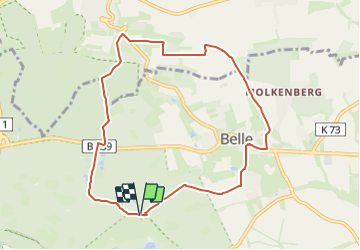
Trail On foot of 7.8 km to be discovered at North Rhine-Westphalia, Kreis Lippe, Horn-Bad Meinberg. This trail is proposed by SityTrail - itinéraires balisés pédestres.
Symbol: weißes A1 auf schwarzem Grund
![Trail On foot Horn-Bad Meinberg - Rundwanderweg [Entenkrug / Belle] - Photo 1](https://media.geolcdn.com/t/2048/auto/d29f987c-f187-4e01-a607-a71c58de997a.jpeg&format=jpg&maxdim=0 "Trail On foot Horn-Bad Meinberg - Rundwanderweg [Entenkrug / Belle] - Photo 1")
![Trail On foot Horn-Bad Meinberg - Rundwanderweg [Entenkrug / Belle] - Photo 2](https://media.geolcdn.com/t/2048/auto/bea47f56-dee1-498a-8c6c-01cc33e14d44.jpeg&format=jpg&maxdim=0 "Trail On foot Horn-Bad Meinberg - Rundwanderweg [Entenkrug / Belle] - Photo 2")
![Trail On foot Horn-Bad Meinberg - Rundwanderweg [Entenkrug / Belle] - Photo 3](https://media.geolcdn.com/t/2048/auto/28dc9979-b982-4c38-8e95-a744ab023a90.jpeg&format=jpg&maxdim=0 "Trail On foot Horn-Bad Meinberg - Rundwanderweg [Entenkrug / Belle] - Photo 3")
![Trail On foot Horn-Bad Meinberg - Rundwanderweg [Entenkrug / Belle] - Photo 4](https://media.geolcdn.com/t/2048/auto/539f9d91-e12e-47ec-982e-fd4862290492.jpeg&format=jpg&maxdim=0 "Trail On foot Horn-Bad Meinberg - Rundwanderweg [Entenkrug / Belle] - Photo 4")
![Trail On foot Horn-Bad Meinberg - Rundwanderweg [Entenkrug / Belle] - Photo 5](https://media.geolcdn.com/t/2048/auto/9e2da189-e14c-4292-a999-33745ed99a73.jpeg&format=jpg&maxdim=0 "Trail On foot Horn-Bad Meinberg - Rundwanderweg [Entenkrug / Belle] - Photo 5")
![Trail On foot Horn-Bad Meinberg - Rundwanderweg [Entenkrug / Belle] - Photo 6](https://media.geolcdn.com/t/2048/auto/4eb0c22a-74a5-4dae-b3f2-f2841ac54cb0.jpeg&format=jpg&maxdim=0 "Trail On foot Horn-Bad Meinberg - Rundwanderweg [Entenkrug / Belle] - Photo 6")
![Trail On foot Horn-Bad Meinberg - Rundwanderweg [Entenkrug / Belle] - Photo 7](https://media.geolcdn.com/t/2048/auto/8fedb237-045e-439a-9962-edb297624f12.jpeg&format=jpg&maxdim=0 "Trail On foot Horn-Bad Meinberg - Rundwanderweg [Entenkrug / Belle] - Photo 7")
![Trail On foot Horn-Bad Meinberg - Rundwanderweg [Entenkrug / Belle] - Photo 8](https://media.geolcdn.com/t/2048/auto/64ef95ed-4751-49ec-a4c1-100596ed91f4.jpeg&format=jpg&maxdim=0 "Trail On foot Horn-Bad Meinberg - Rundwanderweg [Entenkrug / Belle] - Photo 8")
![Trail On foot Horn-Bad Meinberg - Rundwanderweg [Entenkrug / Belle] - Photo 9](https://media.geolcdn.com/t/2048/auto/8c5d76e8-a1f5-4636-8b30-6588ac56056a.jpeg&format=jpg&maxdim=0 "Trail On foot Horn-Bad Meinberg - Rundwanderweg [Entenkrug / Belle] - Photo 9")
![Trail On foot Horn-Bad Meinberg - Rundwanderweg [Entenkrug / Belle] - Photo 10](https://media.geolcdn.com/t/2048/auto/14cfb5d3-5300-4660-b6a5-8c88b2691939.jpeg&format=jpg&maxdim=0 "Trail On foot Horn-Bad Meinberg - Rundwanderweg [Entenkrug / Belle] - Photo 10")
On foot
![Trail On foot Horn-Bad Meinberg - Terrainkurweg 9 [Bad Meinberg] - Photo](https://media.geolcdn.com/t/375/260/415dab2e-d838-41c3-b2c1-c698395be57c.jpeg&format=jpg&maxdim=2)
On foot
![Trail On foot Horn-Bad Meinberg - Terrainkurweg 5 [Bad Meinberg] - Photo](https://media.geolcdn.com/t/375/260/c6c364b8-a98c-4894-be50-01092c15d2a2.jpeg&format=jpg&maxdim=2)
On foot
![Trail On foot Horn-Bad Meinberg - Terrainkurweg 4 [Bad Meinberg] - Photo](https://media.geolcdn.com/t/375/260/17855ced-c021-469c-b31b-b1f4ceaf95e0.jpeg&format=jpg&maxdim=2)
On foot
![Trail On foot Horn-Bad Meinberg - Ruhe - Wanderweg Norderteich [Bad Meinberg] (VitalWanderWelt) - Photo](https://media.geolcdn.com/t/375/260/62948217-785e-4bf8-a3a7-9c99707dba50.jpeg&format=jpg&maxdim=2)
On foot
![Trail On foot Horn-Bad Meinberg - Norderteich-Rundwanderweg [Billerbeck / Entenkrug] - Photo](https://media.geolcdn.com/t/375/260/0fd9e1b3-fa56-43c1-84a2-bd9d47765815.jpeg&format=jpg&maxdim=2)
On foot
On foot
![Trail On foot Detmold - DSV nordic aktiv - schwarze Route [Bad Meinberg] (Nordic Walking) - Photo](https://media.geolcdn.com/t/375/260/aaf5bfea-b5f0-4eb2-baf2-316d21f2e560.jpeg&format=jpg&maxdim=2)
On foot
![Trail On foot Horn-Bad Meinberg - Rundwanderweg A2 [Schauinsland / Entenkrug] - Photo](https://media.geolcdn.com/t/375/260/0c76052b-4685-4552-8bc7-b2246bf963c2.jpeg&format=jpg&maxdim=2)
On foot